Sonchamp elevation
Sonchamp (Île-de-France, Yvelines), France elevation is 139 meters and Sonchamp elevation in feet is 456 ft above sea level [src 1]. Sonchamp is a populated place (feature code) with elevation that is 35 meters (115 ft) smaller than average city elevation in France.
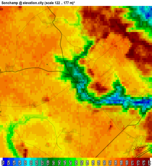
Below is the Elevation map of Sonchamp, which displays elevation range with different colors. Scale of the first map is from 122 to 177 m (400 to 581 ft) with average elevation of 158.1 meters (=519 ft) [note 1]
These maps also provides idea of topography and contour of this city, they are displayed at different zoom levels. More info about maps, scale and edge coordinates you can find below images.
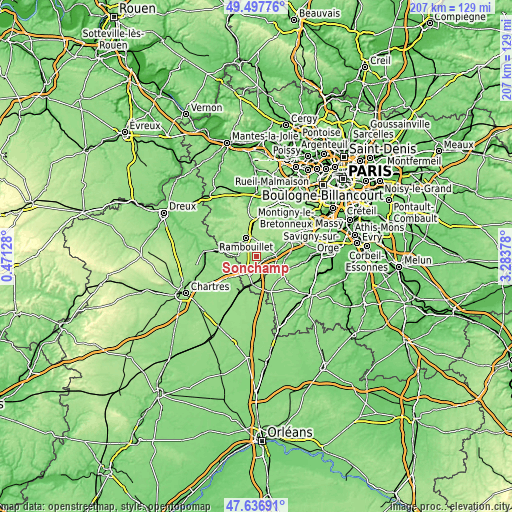
| \ | Map #1 | Topo.Map |
| Scale [m] | 122..177 m | × |
| Scale [ft] | 400..581 ft | × |
| Average | 158.1 m = 519 ft | × |
| Width | 6.47 km = 4 mi | 206.9 km = 128.6 mi |
| Height | 6.47 km = 4 mi | 206.9 km = 128.6 mi |
| ↑Max Latitude | 48.604967° | 49.49776° |
| Latitude at center | 48.5759° | 48.5759° |
| ↓Min Latitude | 48.546816° | 47.63691° |
| ← Min Longitude | 1.833585° | 0.47128° |
| Longitude center | 1.87753° | 1.87753° |
| →Max Longitude | 1.921475° | 3.28378° |
Nearby cities:
Cities around Sonchamp sort by population:
• Rambouillet elevation 161 m
8.3 km,  335°
335°
• Dourdan 95 m
11.2 km,  118°
118°
• Le Perray-en-Yvelines 175 m
13.3 km,  353°
353°
• Saint-Arnoult-en-Yvelines 118 m
4.6 km,  96°
96°
• Ablis 156 m
7.2 km,  204°
204°
• Bonnelles 121 m
12.1 km,  67°
67°
• Bullion 105 m
9.8 km,  57°
57°
• Cernay-la-Ville 167 m
12.9 km,  33°
33°
• Corbreuse 151 m
10.3 km,  144°
144°
• Gazeran 161 m
10 km,  308°
308°
• Droue-sur-Drouette 127 m
13.3 km,  281°
281°
• Saint-Cyr-sous-Dourdan 82 m
11.5 km, 95°
Multilingual:
 En español:
Sonchamp elevación 139 m.
 En France:
Sonchamp élévation 139 m.
 Auf Deutsch:
Sonchamp höhe über dem Meeresspiegel ist 139 m.

Sources and notes:
- [note 1] Map square and city borders are not equal. Map elevation data is calculated only from area inside that square.
- [src 1] Elevation data from geonames database provided with same terms of usage.
- [src 2] The elevation map of Sonchamp is generated using elevation data from NASA's 3 arcsec (90m) resolution SRTM data.
- [src 3] Base (background) map © OpenStreetMap contributors tiles are generated by Geofabrik and OpenTopoMap.
Copyright & License:
This Sonchamp Elevation Map is licensed under CC BY-SA. You may reuse any part from this page, if you give a proper credit by linking to this URL:
 More info on terms of use page.