Saint-Chéron elevation
Saint-Chéron (Île-de-France, Département de l'Essonne), France elevation is 101 meters and Saint-Chéron elevation in feet is 331 ft above sea level [src 1]. Saint-Chéron is a populated place (feature code) with elevation that is 73 meters (240 ft) smaller than average city elevation in France.
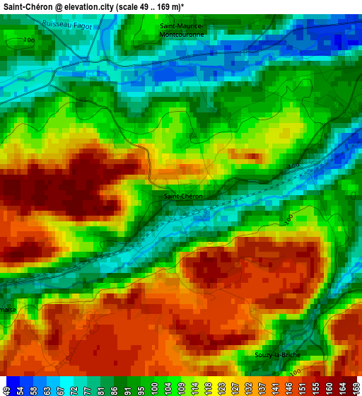
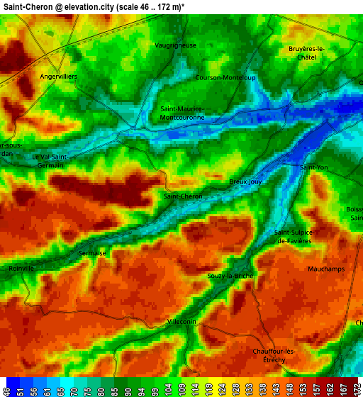
Below is the Elevation map of Saint-Chéron, which displays elevation range with different colors. Scale of the first map is from 49 to 169 m (161 to 554 ft) with average elevation of 109.5 meters (=359 ft) [note 1]
These maps also provides idea of topography and contour of this city, they are displayed at different zoom levels. More info about maps, scale and edge coordinates you can find below images.
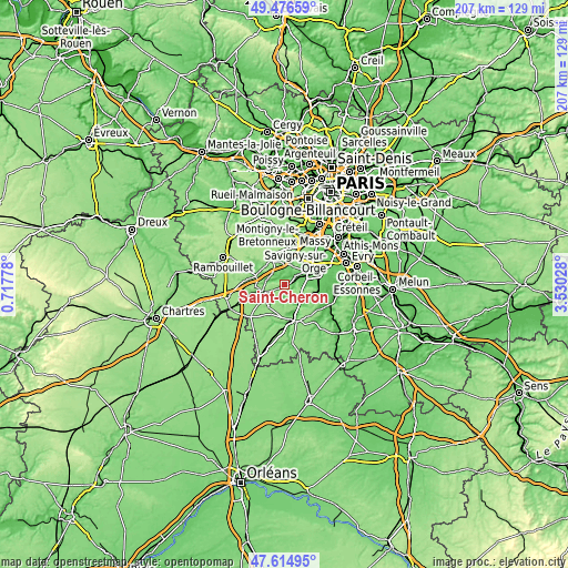
| \ | Map #1 | Map #2 | Topo.Map |
| Scale [m] | 49..169 m | 46..172 m | × |
| Scale [ft] | 161..554 ft | 151..564 ft | × |
| Average | 109.5 m = 359 ft | 116 m = 381 ft | × |
| Width | 6.47 km = 4 mi | 12.94 km = 8 mi | 207 km = 128.6 mi |
| Height | 6.47 km = 4 mi | 12.94 km = 8 mi | 207 km = 128.6 mi |
| ↑Max Latitude | 48.583409° | 48.612472° | 49.47659° |
| Latitude at center | 48.55433° | 48.55433° | 48.55433° |
| ↓Min Latitude | 48.525234° | 48.496121° | 47.61495° |
| ← Min Longitude | 2.080085° | 2.036139° | 0.71778° |
| Longitude center | 2.12403° | 2.12403° | 2.12403° |
| →Max Longitude | 2.167975° | 2.211921° | 3.53028° |
Nearby cities:
Cities around Saint-Chéron sort by population:
• Breuillet elevation 92 m
4.1 km,  63°
63°
• Égly 85 m
7.8 km,  70°
70°
• Boissy-sous-Saint-Yon 91 m
6.5 km,  90°
90°
• Briis-sous-Forges 101 m
7.7 km,  358°
358°
• Bruyères-le-Châtel 82 m
6.2 km,  51°
51°
• Fontenay-lès-Briis 112 m
7.6 km,  16°
16°
• Le Val-Saint-Germain 76 m
4.6 km,  286°
286°
• Angervilliers 115 m
6.1 km,  314°
314°
• Saint-Maurice-Montcouronne 96 m
3.2 km,  1°
1°
• Vaugrigneuse 82 m
5.4 km, 358°
• Chamarande 98 m
8 km,  121°
121°
• Saint-Cyr-sous-Dourdan 82 m
6.8 km,  281°
281°
Multilingual:
 En español:
Saint-Chéron elevación 101 m.
 En France:
Saint-Chéron élévation 101 m.
 Auf Deutsch:
Saint-Chéron höhe über dem Meeresspiegel ist 101 m.

Sources and notes:
- [note 1] Map square and city borders are not equal. Map elevation data is calculated only from area inside that square.
- [src 1] Elevation data from geonames database provided with same terms of usage.
- [src 2] The elevation map of Saint-Chéron is generated using elevation data from NASA's 3 arcsec (90m) resolution SRTM data.
- [src 3] Base (background) map © OpenStreetMap contributors tiles are generated by Geofabrik and OpenTopoMap.
Copyright & License:
This Saint-Chéron Elevation Map is licensed under CC BY-SA. You may reuse any part from this page, if you give a proper credit by linking to this URL:
 More info on terms of use page.