Hauteville-Lompnes elevation
Hauteville-Lompnes (Auvergne-Rhône-Alpes, Département de l'Ain), France elevation is 804 meters and Hauteville-Lompnes elevation in feet is 2638 ft above sea level [src 1]. Hauteville-Lompnes is a populated place (feature code) with elevation that is 630 meters (2067 ft) bigger than average city elevation in France.
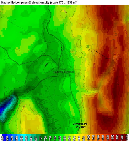
Below is the Elevation map of Hauteville-Lompnes, which displays elevation range with different colors. Scale of the first map is from 470 to 1239 m (1542 to 4065 ft) with average elevation of 917 meters (=3009 ft) [note 1]
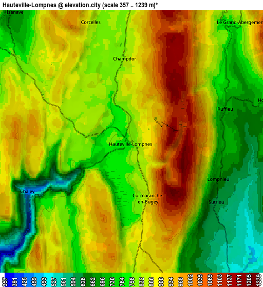
These maps also provides idea of topography and contour of this city, they are displayed at different zoom levels. More info about maps, scale and edge coordinates you can find below images.
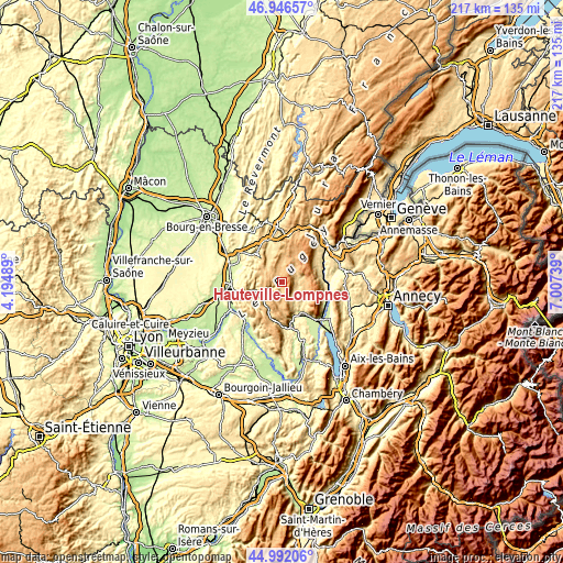
| \ | Map #1 | Map #2 | Topo.Map |
| Scale [m] | 470..1239 m | 357..1239 m | × |
| Scale [ft] | 1542..4065 ft | 1171..4065 ft | × |
| Average | 917 m = 3009 ft | 841.1 m = 2760 ft | × |
| Width | 6.79 km = 4.2 mi | 13.58 km = 8.4 mi | 217.3 km = 135 mi |
| Height | 6.79 km = 4.2 mi | 13.58 km = 8.4 mi | 217.3 km = 135 mi |
| ↑Max Latitude | 46.008471° | 46.038985° | 46.94657° |
| Latitude at center | 45.97794° | 45.97794° | 45.97794° |
| ↓Min Latitude | 45.947392° | 45.916828° | 44.99206° |
| ← Min Longitude | 5.557195° | 5.513249° | 4.19489° |
| Longitude center | 5.60114° | 5.60114° | 5.60114° |
| →Max Longitude | 5.645085° | 5.689031° | 7.00739° |
Nearby cities:
Cities around Hauteville-Lompnes sort by population:
• Ambérieu-en-Bugey elevation 300 m
19.4 km,  263°
263°
• Nantua 593 m
19.5 km,  1°
1°
• Ambronay 301 m
18.7 km,  279°
279°
• Saint-Rambert-en-Bugey 420 m
13.2 km, 255°
• Jujurieux 382 m
16.5 km,  295°
295°
• Poncin 336 m
18.9 km,  309°
309°
• Saint-Jean-le-Vieux 265 m
17.5 km,  289°
289°
• Tenay 387 m
9.8 km,  227°
227°
• Saint-Martin-du-Frêne 675 m
18 km,  347°
347°
• Artemare 255 m
13.6 km,  148°
148°
• Villebois 262 m
19.4 km,  222°
222°
• Virieu-le-Grand 373 m
15 km,  164°
164°
Multilingual:
 En español:
Hauteville-Lompnes elevación 804 m.
 En France:
Hauteville-Lompnes élévation 804 m.
 Auf Deutsch:
Hauteville-Lompnes höhe über dem Meeresspiegel ist 804 m.

Sources and notes:
- [note 1] Map square and city borders are not equal. Map elevation data is calculated only from area inside that square.
- [src 1] Elevation data from geonames database provided with same terms of usage.
- [src 2] The elevation map of Hauteville-Lompnes is generated using elevation data from NASA's 3 arcsec (90m) resolution SRTM data.
- [src 3] Base (background) map © OpenStreetMap contributors tiles are generated by Geofabrik and OpenTopoMap.
Copyright & License:
This Hauteville-Lompnes Elevation Map is licensed under CC BY-SA. You may reuse any part from this page, if you give a proper credit by linking to this URL:
 More info on terms of use page.