Tenay elevation
Tenay (Auvergne-Rhône-Alpes, Département de l'Ain), France elevation is 387 meters and Tenay elevation in feet is 1270 ft above sea level [src 1]. Tenay is a populated place (feature code) with elevation that is 213 meters (699 ft) bigger than average city elevation in France.
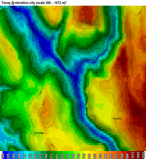
Below is the Elevation map of Tenay, which displays elevation range with different colors. Scale of the first map is from 306 to 1072 m (1004 to 3517 ft) with average elevation of 671.5 meters (=2203 ft) [note 1]
These maps also provides idea of topography and contour of this city, they are displayed at different zoom levels. More info about maps, scale and edge coordinates you can find below images.
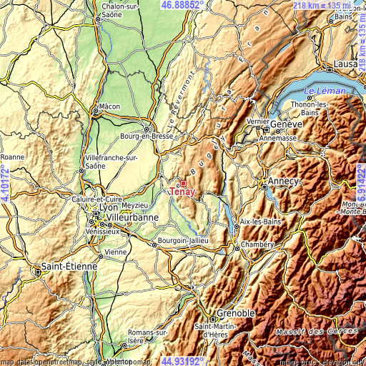
| \ | Map #1 | Topo.Map |
| Scale [m] | 306..1072 m | × |
| Scale [ft] | 1004..3517 ft | × |
| Average | 671.5 m = 2203 ft | × |
| Width | 6.8 km = 4.2 mi | 217.6 km = 135.2 mi |
| Height | 6.8 km = 4.2 mi | 217.5 km = 135.1 mi |
| ↑Max Latitude | 45.949403° | 46.88852° |
| Latitude at center | 45.91884° | 45.91884° |
| ↓Min Latitude | 45.88826° | 44.93192° |
| ← Min Longitude | 5.464025° | 4.10172° |
| Longitude center | 5.50797° | 5.50797° |
| →Max Longitude | 5.551915° | 6.91422° |
Nearby cities:
Cities around Tenay sort by population:
• Ambérieu-en-Bugey elevation 300 m
12.9 km,  290°
290°
• Lagnieu 235 m
12.8 km,  261°
261°
• Hauteville-Lompnes 804 m
9.8 km,  47°
47°
• Montalieu 213 m
14.4 km,  214°
214°
• Saint-Rambert-en-Bugey 420 m
6.4 km,  299°
299°
• Porcieu 264 m
12.5 km,  221°
221°
• Serrières-de-Briord 226 m
13.3 km,  200°
200°
• Vaux-en-Bugey 344 m
12.1 km,  274°
274°
• Villebois 262 m
9.8 km, 216°
• Saint-Sorlin-en-Bugey 439 m
11.5 km,  251°
251°
• Sault-Brénaz 270 m
10.6 km,  232°
232°
• Virieu-le-Grand 373 m
13.6 km,  125°
125°
Multilingual:
 En español:
Tenay elevación 387 m.
 En France:
Tenay élévation 387 m.


Sources and notes:
- [note 1] Map square and city borders are not equal. Map elevation data is calculated only from area inside that square.
- [src 1] Elevation data from geonames database provided with same terms of usage.
- [src 2] The elevation map of Tenay is generated using elevation data from NASA's 3 arcsec (90m) resolution SRTM data.
- [src 3] Base (background) map © OpenStreetMap contributors tiles are generated by Geofabrik and OpenTopoMap.
Copyright & License:
This Tenay Elevation Map is licensed under CC BY-SA. You may reuse any part from this page, if you give a proper credit by linking to this URL:
 More info on terms of use page.