Jujurieux elevation
Jujurieux (Auvergne-Rhône-Alpes, Département de l'Ain), France elevation is 382 meters and Jujurieux elevation in feet is 1253 ft above sea level [src 1]. Jujurieux is a populated place (feature code) with elevation that is 208 meters (682 ft) bigger than average city elevation in France.
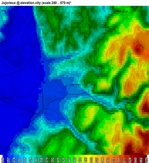
Below is the Elevation map of Jujurieux, which displays elevation range with different colors. Scale of the first map is from 240 to 679 m (787 to 2228 ft) with average elevation of 365.9 meters (=1200 ft) [note 1]
These maps also provides idea of topography and contour of this city, they are displayed at different zoom levels. More info about maps, scale and edge coordinates you can find below images.
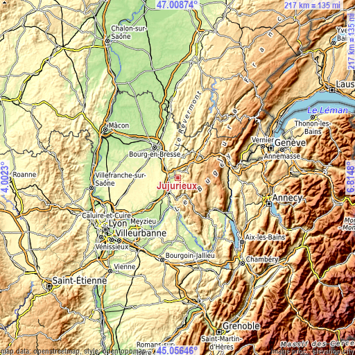
| \ | Map #1 | Topo.Map |
| Scale [m] | 240..679 m | × |
| Scale [ft] | 787..2228 ft | × |
| Average | 365.9 m = 1200 ft | × |
| Width | 6.78 km = 4.2 mi | 217.1 km = 134.9 mi |
| Height | 6.78 km = 4.2 mi | 217.1 km = 134.9 mi |
| ↑Max Latitude | 46.071716° | 47.00874° |
| Latitude at center | 46.04122° | 46.04122° |
| ↓Min Latitude | 46.010707° | 45.05646° |
| ← Min Longitude | 5.364605° | 4.0023° |
| Longitude center | 5.40855° | 5.40855° |
| →Max Longitude | 5.452495° | 6.8148° |
Nearby cities:
Cities around Jujurieux sort by population:
• Ambérieu-en-Bugey elevation 300 m
10.1 km,  205°
205°
• Pont-d’Ain 270 m
5.6 km,  287°
287°
• Ambronay 301 m
5.4 km,  221°
221°
• Saint-Rambert-en-Bugey 420 m
10.7 km,  168°
168°
• Saint-Denis-en-Bugey 247 m
11.9 km, 211°
• Château-Gaillard 235 m
11.1 km,  226°
226°
• Poncin 336 m
4.9 km,  2°
2°
• Saint-Jean-le-Vieux 265 m
2 km, 231°
• Saint-Martin-du-Mont 360 m
9.5 km,  311°
311°
• Neuville-sur-Ain 249 m
4.2 km,  322°
322°
• Priay 233 m
10.4 km,  245°
245°
• Tossiat 260 m
13.3 km,  325°
325°
Multilingual:
 En español:
Jujurieux elevación 382 m.
 En France:
Jujurieux élévation 382 m.
 Auf Deutsch:
Jujurieux höhe über dem Meeresspiegel ist 382 m.

Sources and notes:
- [note 1] Map square and city borders are not equal. Map elevation data is calculated only from area inside that square.
- [src 1] Elevation data from geonames database provided with same terms of usage.
- [src 2] The elevation map of Jujurieux is generated using elevation data from NASA's 3 arcsec (90m) resolution SRTM data.
- [src 3] Base (background) map © OpenStreetMap contributors tiles are generated by Geofabrik and OpenTopoMap.
Copyright & License:
This Jujurieux Elevation Map is licensed under CC BY-SA. You may reuse any part from this page, if you give a proper credit by linking to this URL:
 More info on terms of use page.