Lacaune elevation
Lacaune (Occitanie, Tarn), France elevation is 798 meters and Lacaune elevation in feet is 2618 ft above sea level [src 1]. Lacaune is a populated place (feature code) with elevation that is 624 meters (2047 ft) bigger than average city elevation in France.
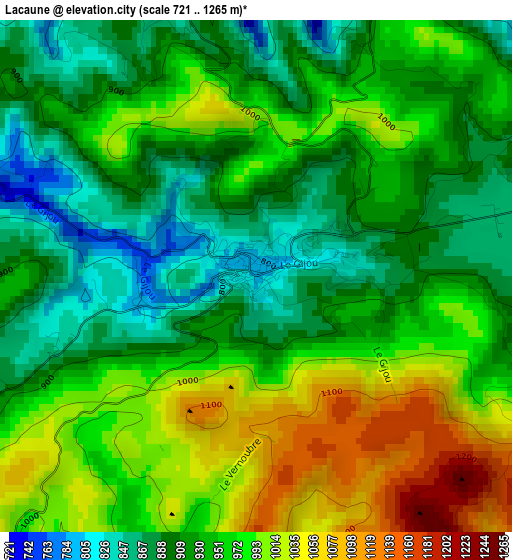
Below is the Elevation map of Lacaune, which displays elevation range with different colors. Scale of the first map is from 721 to 1265 m (2365 to 4150 ft) with average elevation of 949.1 meters (=3114 ft) [note 1]
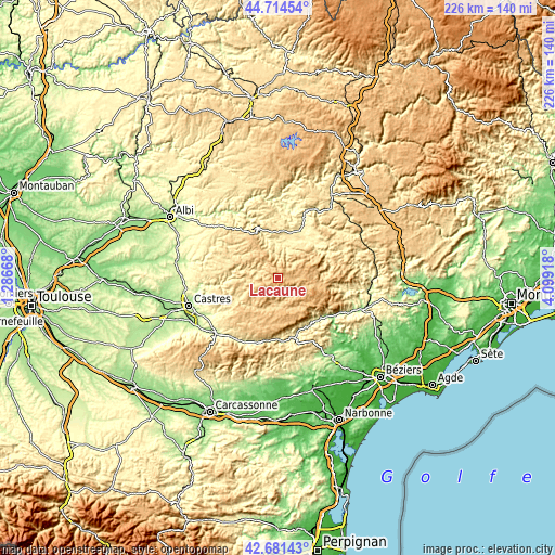
These maps also provides idea of topography and contour of this city, they are displayed at different zoom levels. More info about maps, scale and edge coordinates you can find below images.
| \ | Map #1 | Topo.Map |
| Scale [m] | 721..1265 m | × |
| Scale [ft] | 2365..4150 ft | × |
| Average | 949.1 m = 3114 ft | × |
| Width | 7.06 km = 4.4 mi | 226.1 km = 140.5 mi |
| Height | 7.06 km = 4.4 mi | 226.1 km = 140.5 mi |
| ↑Max Latitude | 43.738359° | 44.71454° |
| Latitude at center | 43.7066° | 43.7066° |
| ↓Min Latitude | 43.674824° | 42.68143° |
| ← Min Longitude | 2.648985° | 1.28668° |
| Longitude center | 2.69293° | 2.69293° |
| →Max Longitude | 2.736875° | 4.09918° |
Nearby cities:
Cities around Lacaune sort by population:
• Saint-Affrique elevation 324 m
31.9 km,  29°
29°
• Saint-Pons-de-Thomières 338 m
25.5 km,  166°
166°
• Montredon-Labessonnié 517 m
29.6 km,  272°
272°
• Burlats 198 m
31.1 km,  255°
255°
• Saint-Amans-Soult 288 m
30.3 km,  212°
212°
• Labastide-Rouairoux 393 m
26 km,  189°
189°
• Lacrouzette 518 m
28.2 km, 259°
• Brassac 490 m
17.9 km,  241°
241°
• La Salvetat-sur-Agout 784 m
12 km, 170°
• Camarès 385 m
19.8 km,  49°
49°
• Belmont-sur-Rance 482 m
13.5 km,  21°
21°
• Saint-Amans-Valtoret 288 m
29.9 km, 212°
Multilingual:
 En español:
Lacaune elevación 798 m.
 En France:
Lacaune élévation 798 m.


Sources and notes:
- [note 1] Map square and city borders are not equal. Map elevation data is calculated only from area inside that square.
- [src 1] Elevation data from geonames database provided with same terms of usage.
- [src 2] The elevation map of Lacaune is generated using elevation data from NASA's 3 arcsec (90m) resolution SRTM data.
- [src 3] Base (background) map © OpenStreetMap contributors tiles are generated by Geofabrik and OpenTopoMap.
Copyright & License:
This Lacaune Elevation Map is licensed under CC BY-SA. You may reuse any part from this page, if you give a proper credit by linking to this URL:
 More info on terms of use page.