Saint-Pons-de-Thomières elevation
Saint-Pons-de-Thomières (Occitanie, Département de l'Hérault), France elevation is 338 meters and Saint-Pons-de-Thomières elevation in feet is 1109 ft above sea level [src 1]. Saint-Pons-de-Thomières is a populated place (feature code) with elevation that is 164 meters (538 ft) bigger than average city elevation in France.
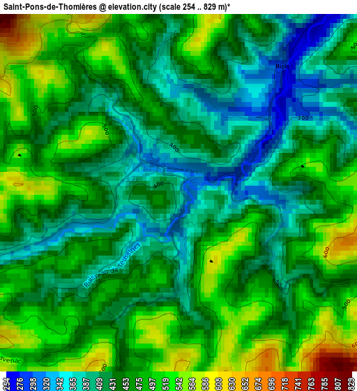
Below is the Elevation map of Saint-Pons-de-Thomières, which displays elevation range with different colors. Scale of the first map is from 254 to 829 m (833 to 2720 ft) with average elevation of 454.2 meters (=1490 ft) [note 1]
These maps also provides idea of topography and contour of this city, they are displayed at different zoom levels. More info about maps, scale and edge coordinates you can find below images.
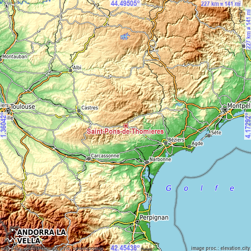
| \ | Map #1 | Topo.Map |
| Scale [m] | 254..829 m | × |
| Scale [ft] | 833..2720 ft | × |
| Average | 454.2 m = 1490 ft | × |
| Width | 7.09 km = 4.4 mi | 226.9 km = 141 mi |
| Height | 7.09 km = 4.4 mi | 226.9 km = 141 mi |
| ↑Max Latitude | 43.515207° | 44.49505° |
| Latitude at center | 43.48333° | 43.48333° |
| ↓Min Latitude | 43.451436° | 42.45438° |
| ← Min Longitude | 2.722725° | 1.36042° |
| Longitude center | 2.76667° | 2.76667° |
| →Max Longitude | 2.810615° | 4.17292° |
Nearby cities:
Cities around Saint-Pons-de-Thomières sort by population:
• Saint-Chinian elevation 124 m
16 km,  115°
115°
• Cessenon-sur-Orb 61 m
23.3 km,  99°
99°
• Saint-Amans-Soult 288 m
22.3 km,  268°
268°
• Labastide-Rouairoux 393 m
10.3 km, 265°
• Olonzac 53 m
22.5 km,  187°
187°
• Quarante 112 m
21.9 km,  133°
133°
• Argeliers 45 m
22.3 km,  148°
148°
• La Salvetat-sur-Agout 784 m
13.6 km,  342°
342°
• Creissan 109 m
23.2 km, 121°
• Pépieux 89 m
21.8 km,  198°
198°
• Bize-Minervois 59 m
20.4 km,  155°
155°
• Saint-Amans-Valtoret 288 m
22.2 km, 269°
Multilingual:
 En español:
Saint-Pons-de-Thomières elevación 338 m.
 En France:
Saint-Pons-de-Thomières élévation 338 m.
 Auf Deutsch:
Saint-Pons-de-Thomières höhe über dem Meeresspiegel ist 338 m.
 На русском:
Saint-Pons-de-Thomières высота над уровнем моря 338 м
Sources and notes:
- [note 1] Map square and city borders are not equal. Map elevation data is calculated only from area inside that square.
- [src 1] Elevation data from geonames database provided with same terms of usage.
- [src 2] The elevation map of Saint-Pons-de-Thomières is generated using elevation data from NASA's 3 arcsec (90m) resolution SRTM data.
- [src 3] Base (background) map © OpenStreetMap contributors tiles are generated by Geofabrik and OpenTopoMap.
Copyright & License:
This Saint-Pons-de-Thomières Elevation Map is licensed under CC BY-SA. You may reuse any part from this page, if you give a proper credit by linking to this URL:
 More info on terms of use page.