Camarès elevation
Camarès (Occitanie, Département de l'Aveyron), France elevation is 385 meters and Camarès elevation in feet is 1263 ft above sea level [src 1]. Camarès is a populated place (feature code) with elevation that is 211 meters (692 ft) bigger than average city elevation in France.
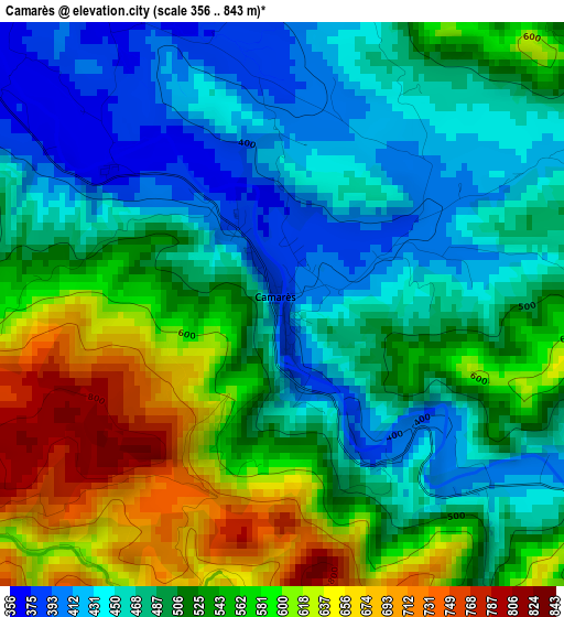
Below is the Elevation map of Camarès, which displays elevation range with different colors. Scale of the first map is from 356 to 843 m (1168 to 2766 ft) with average elevation of 517.3 meters (=1697 ft) [note 1]
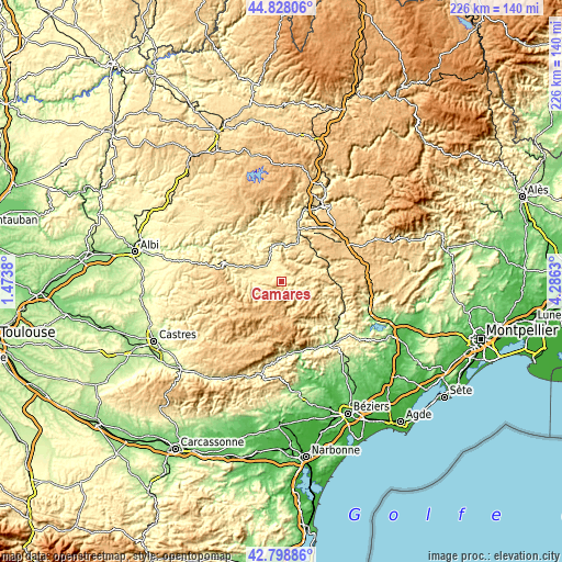
These maps also provides idea of topography and contour of this city, they are displayed at different zoom levels. More info about maps, scale and edge coordinates you can find below images.
| \ | Map #1 | Topo.Map |
| Scale [m] | 356..843 m | × |
| Scale [ft] | 1168..2766 ft | × |
| Average | 517.3 m = 1697 ft | × |
| Width | 7.05 km = 4.4 mi | 225.6 km = 140.2 mi |
| Height | 7.05 km = 4.4 mi | 225.6 km = 140.2 mi |
| ↑Max Latitude | 43.853778° | 44.82806° |
| Latitude at center | 43.82208° | 43.82208° |
| ↓Min Latitude | 43.790365° | 42.79886° |
| ← Min Longitude | 2.836105° | 1.4738° |
| Longitude center | 2.88005° | 2.88005° |
| →Max Longitude | 2.923995° | 4.2863° |
Nearby cities:
Cities around Camarès sort by population:
• Saint-Affrique elevation 324 m
14.9 km,  2°
2°
• Bédarieux 198 m
32 km,  135°
135°
• Lacaune 798 m
19.8 km,  229°
229°
• Lamalou-les-Bains 190 m
29.7 km,  147°
147°
• Le Bousquet-d’Orb 254 m
27.2 km,  121°
121°
• Hérépian 191 m
31.8 km, 143°
• Saint-Georges-de-Luzençon 362 m
28.3 km,  17°
17°
• La Salvetat-sur-Agout 784 m
28 km,  208°
208°
• La Tour-sur-Orb 221 m
28.8 km,  131°
131°
• La Cavalerie 794 m
30.5 km,  46°
46°
• Belmont-sur-Rance 482 m
10 km,  268°
268°
• Le Poujol-sur-Orb 174 m
30.7 km, 151°
Multilingual:
 En español:
Camarès elevación 385 m.
 En France:
Camarès élévation 385 m.


Sources and notes:
- [note 1] Map square and city borders are not equal. Map elevation data is calculated only from area inside that square.
- [src 1] Elevation data from geonames database provided with same terms of usage.
- [src 2] The elevation map of Camarès is generated using elevation data from NASA's 3 arcsec (90m) resolution SRTM data.
- [src 3] Base (background) map © OpenStreetMap contributors tiles are generated by Geofabrik and OpenTopoMap.
Copyright & License:
This Camarès Elevation Map is licensed under CC BY-SA. You may reuse any part from this page, if you give a proper credit by linking to this URL:
 More info on terms of use page.