Saint-Affrique elevation
Saint-Affrique (Occitanie, Département de l'Aveyron), France elevation is 324 meters and Saint-Affrique elevation in feet is 1063 ft above sea level [src 1]. Saint-Affrique is a populated place (feature code) with elevation that is 150 meters (492 ft) bigger than average city elevation in France.
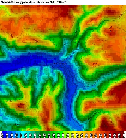
Below is the Elevation map of Saint-Affrique, which displays elevation range with different colors. Scale of the first map is from 304 to 716 m (997 to 2349 ft) with average elevation of 505.5 meters (=1658 ft) [note 1]
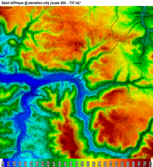
These maps also provides idea of topography and contour of this city, they are displayed at different zoom levels. More info about maps, scale and edge coordinates you can find below images.
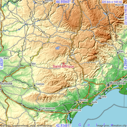
| \ | Map #1 | Map #2 | Topo.Map |
| Scale [m] | 304..716 m | 294..737 m | × |
| Scale [ft] | 997..2349 ft | 965..2418 ft | × |
| Average | 505.5 m = 1658 ft | 515.9 m = 1693 ft | × |
| Width | 7.03 km = 4.4 mi | 14.07 km = 8.7 mi | 225.1 km = 139.9 mi |
| Height | 7.04 km = 4.4 mi | 14.07 km = 8.7 mi | 225.1 km = 139.9 mi |
| ↑Max Latitude | 43.987377° | 44.018987° | 44.95945° |
| Latitude at center | 43.95575° | 43.95575° | 43.95575° |
| ↓Min Latitude | 43.924106° | 43.892446° | 42.93481° |
| ← Min Longitude | 2.845205° | 2.801259° | 1.4829° |
| Longitude center | 2.88915° | 2.88915° | 2.88915° |
| →Max Longitude | 2.933095° | 2.977041° | 4.2954° |
Nearby cities:
Cities around Saint-Affrique sort by population:
• Millau elevation 354 m
21.8 km,  43°
43°
• Lacaune 798 m
31.9 km,  209°
209°
• Réquista 563 m
29.6 km,  286°
286°
• Le Bousquet-d’Orb 254 m
36.8 km,  142°
142°
• Creissels 381 m
19.9 km, 43°
• Pont-de-Salars 707 m
38.4 km,  340°
340°
• Saint-Georges-de-Luzençon 362 m
14.4 km,  32°
32°
• Salles-Curan 856 m
26.4 km, 342°
• Camarès 385 m
14.9 km,  182°
182°
• La Cavalerie 794 m
22.4 km,  74°
74°
• Belmont-sur-Rance 482 m
18.5 km,  215°
215°
• Cassagnes-Bégonhès 540 m
37.2 km,  309°
309°
Multilingual:
 En español:
Saint-Affrique elevación 324 m.
 En France:
Saint-Affrique élévation 324 m.
 Auf Deutsch:
Saint-Affrique höhe über dem Meeresspiegel ist 324 m.

Sources and notes:
- [note 1] Map square and city borders are not equal. Map elevation data is calculated only from area inside that square.
- [src 1] Elevation data from geonames database provided with same terms of usage.
- [src 2] The elevation map of Saint-Affrique is generated using elevation data from NASA's 3 arcsec (90m) resolution SRTM data.
- [src 3] Base (background) map © OpenStreetMap contributors tiles are generated by Geofabrik and OpenTopoMap.
Copyright & License:
This Saint-Affrique Elevation Map is licensed under CC BY-SA. You may reuse any part from this page, if you give a proper credit by linking to this URL:
 More info on terms of use page.