Creissels elevation
Creissels (Occitanie, Département de l'Aveyron), France elevation is 381 meters and Creissels elevation in feet is 1250 ft above sea level [src 1]. Creissels is a populated place (feature code) with elevation that is 207 meters (679 ft) bigger than average city elevation in France.
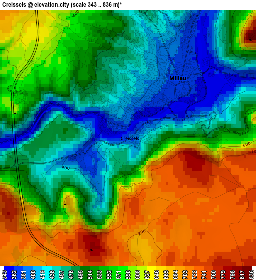
Below is the Elevation map of Creissels, which displays elevation range with different colors. Scale of the first map is from 343 to 836 m (1125 to 2743 ft) with average elevation of 555.4 meters (=1822 ft) [note 1]
These maps also provides idea of topography and contour of this city, they are displayed at different zoom levels. More info about maps, scale and edge coordinates you can find below images.
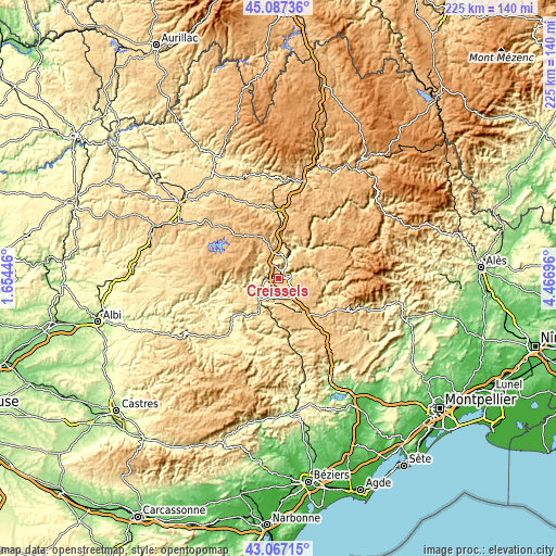
| \ | Map #1 | Topo.Map |
| Scale [m] | 343..836 m | × |
| Scale [ft] | 1125..2743 ft | × |
| Average | 555.4 m = 1822 ft | × |
| Width | 7.02 km = 4.4 mi | 224.6 km = 139.6 mi |
| Height | 7.02 km = 4.4 mi | 224.6 km = 139.6 mi |
| ↑Max Latitude | 44.117437° | 45.08736° |
| Latitude at center | 44.08588° | 44.08588° |
| ↓Min Latitude | 44.054306° | 43.06715° |
| ← Min Longitude | 3.016765° | 1.65446° |
| Longitude center | 3.06071° | 3.06071° |
| →Max Longitude | 3.104655° | 4.46696° |
Nearby cities:
Cities around Creissels sort by population:
• Millau elevation 354 m
1.9 km,  45°
45°
• Saint-Affrique 324 m
19.9 km,  223°
223°
• Sévérac-le-Château 681 m
26.5 km,  359°
359°
• La Canourgue 565 m
40.3 km,  17°
17°
• Laissac 596 m
37.9 km,  329°
329°
• Pont-de-Salars 707 m
34.3 km,  309°
309°
• Saint-Georges-de-Luzençon 362 m
6.4 km,  248°
248°
• Salles-Curan 856 m
24.2 km,  296°
296°
• Meyrueis 705 m
31.2 km,  70°
70°
• Camarès 385 m
32.7 km,  206°
206°
• La Cavalerie 794 m
11.5 km,  137°
137°
• Belmont-sur-Rance 482 m
38.4 km, 219°
Multilingual:
 En español:
Creissels elevación 381 m.
 En France:
Creissels élévation 381 m.
 Auf Deutsch:
Creissels höhe über dem Meeresspiegel ist 381 m.

Sources and notes:
- [note 1] Map square and city borders are not equal. Map elevation data is calculated only from area inside that square.
- [src 1] Elevation data from geonames database provided with same terms of usage.
- [src 2] The elevation map of Creissels is generated using elevation data from NASA's 3 arcsec (90m) resolution SRTM data.
- [src 3] Base (background) map © OpenStreetMap contributors tiles are generated by Geofabrik and OpenTopoMap.
Copyright & License:
This Creissels Elevation Map is licensed under CC BY-SA. You may reuse any part from this page, if you give a proper credit by linking to this URL:
 More info on terms of use page.