La Courtine elevation
La Courtine (Nouvelle-Aquitaine, Creuse), France elevation is 774 meters and La Courtine elevation in feet is 2539 ft above sea level [src 1]. La Courtine is a populated place (feature code) with elevation that is 600 meters (1969 ft) bigger than average city elevation in France.
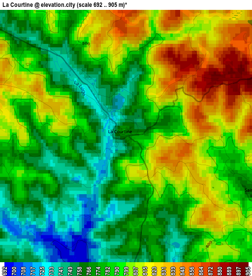
Below is the Elevation map of La Courtine, which displays elevation range with different colors. Scale of the first map is from 692 to 905 m (2270 to 2969 ft) with average elevation of 789.5 meters (=2590 ft) [note 1]
These maps also provides idea of topography and contour of this city, they are displayed at different zoom levels. More info about maps, scale and edge coordinates you can find below images.
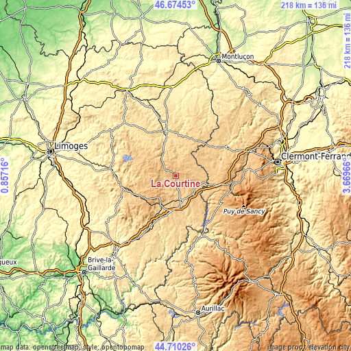
| \ | Map #1 | Topo.Map |
| Scale [m] | 692..905 m | × |
| Scale [ft] | 2270..2969 ft | × |
| Average | 789.5 m = 2590 ft | × |
| Width | 6.83 km = 4.2 mi | 218.4 km = 135.7 mi |
| Height | 6.83 km = 4.2 mi | 218.4 km = 135.7 mi |
| ↑Max Latitude | 45.731703° | 46.67453° |
| Latitude at center | 45.70102° | 45.70102° |
| ↓Min Latitude | 45.67032° | 44.71026° |
| ← Min Longitude | 2.219465° | 0.85716° |
| Longitude center | 2.26341° | 2.26341° |
| →Max Longitude | 2.307355° | 3.66966° |
Nearby cities:
Cities around La Courtine sort by population:
• Ussel elevation 629 m
17.4 km,  168°
168°
• Égletons 612 m
36.9 km,  207°
207°
• Aubusson 512 m
29.2 km,  345°
345°
• Bort-les-Orgues 492 m
38.1 km,  151°
151°
• Meymac 669 m
20.5 km, 206°
• Felletin 562 m
21.5 km,  341°
341°
• Neuvic 610 m
35.6 km,  179°
179°
• La Bourboule 855 m
39.1 km,  108°
108°
• Lanobre 683 m
36 km,  144°
144°
• Messeix 777 m
23.5 km, 113°
• Saint-Sauves-d'Auvergne 888 m
34.5 km, 108°
• Bugeat 740 m
28.5 km,  246°
246°
Multilingual:
 En español:
La Courtine elevación 774 m.
 En France:
La Courtine élévation 774 m.
 Auf Deutsch:
La Courtine höhe über dem Meeresspiegel ist 774 m.

Sources and notes:
- [note 1] Map square and city borders are not equal. Map elevation data is calculated only from area inside that square.
- [src 1] Elevation data from geonames database provided with same terms of usage.
- [src 2] The elevation map of La Courtine is generated using elevation data from NASA's 3 arcsec (90m) resolution SRTM data.
- [src 3] Base (background) map © OpenStreetMap contributors tiles are generated by Geofabrik and OpenTopoMap.
Copyright & License:
This La Courtine Elevation Map is licensed under CC BY-SA. You may reuse any part from this page, if you give a proper credit by linking to this URL:
 More info on terms of use page.