Égletons elevation
Égletons (Nouvelle-Aquitaine, Département de la Corrèze), France elevation is 612 meters and Égletons elevation in feet is 2008 ft above sea level [src 1]. Égletons is a populated place (feature code) with elevation that is 438 meters (1437 ft) bigger than average city elevation in France.
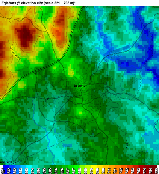
Below is the Elevation map of Égletons, which displays elevation range with different colors. Scale of the first map is from 521 to 795 m (1709 to 2608 ft) with average elevation of 612.8 meters (=2010 ft) [note 1]
These maps also provides idea of topography and contour of this city, they are displayed at different zoom levels. More info about maps, scale and edge coordinates you can find below images.
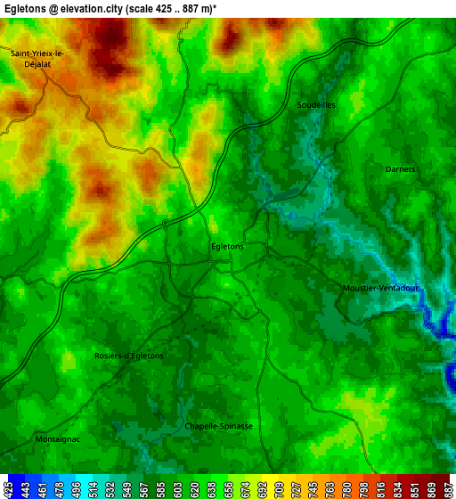
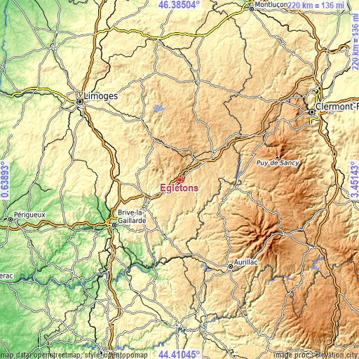
| \ | Map #1 | Map #2 | Topo.Map |
| Scale [m] | 521..795 m | 425..887 m | × |
| Scale [ft] | 1709..2608 ft | 1394..2910 ft | × |
| Average | 612.8 m = 2010 ft | 626.1 m = 2054 ft | × |
| Width | 6.86 km = 4.3 mi | 13.72 km = 8.5 mi | 219.6 km = 136.5 mi |
| Height | 6.86 km = 4.3 mi | 13.72 km = 8.5 mi | 219.5 km = 136.4 mi |
| ↑Max Latitude | 45.437214° | 45.468042° | 46.38504° |
| Latitude at center | 45.40637° | 45.40637° | 45.40637° |
| ↓Min Latitude | 45.375509° | 45.344631° | 44.41045° |
| ← Min Longitude | 2.001235° | 1.957289° | 0.63893° |
| Longitude center | 2.04518° | 2.04518° | 2.04518° |
| →Max Longitude | 2.089125° | 2.133071° | 3.45143° |
Nearby cities:
Cities around Égletons sort by population:
• Tulle elevation 307 m
26.4 km,  233°
233°
• Ussel 629 m
25.9 km,  52°
52°
• Meymac 669 m
16.4 km,  28°
28°
• Naves 412 m
24 km,  244°
244°
• Neuvic 610 m
17.9 km,  98°
98°
• Seilhac 495 m
26.3 km,  260°
260°
• Laguenne 220 m
27.5 km, 228°
• Treignac 491 m
24.3 km,  306°
306°
• Champagnac 630 m
28.2 km, 101°
• Corrèze 477 m
13.8 km,  254°
254°
• Chamboulive 433 m
26.7 km,  276°
276°
• Bugeat 740 m
23.2 km,  336°
336°
Multilingual:
 En español:
Égletons elevación 612 m.
 En France:
Égletons élévation 612 m.
 Auf Deutsch:
Égletons höhe über dem Meeresspiegel ist 612 m.

Sources and notes:
- [note 1] Map square and city borders are not equal. Map elevation data is calculated only from area inside that square.
- [src 1] Elevation data from geonames database provided with same terms of usage.
- [src 2] The elevation map of Égletons is generated using elevation data from NASA's 3 arcsec (90m) resolution SRTM data.
- [src 3] Base (background) map © OpenStreetMap contributors tiles are generated by Geofabrik and OpenTopoMap.
Copyright & License:
This Égletons Elevation Map is licensed under CC BY-SA. You may reuse any part from this page, if you give a proper credit by linking to this URL:
 More info on terms of use page.