Bugeat elevation
Bugeat (Nouvelle-Aquitaine, Département de la Corrèze), France elevation is 740 meters and Bugeat elevation in feet is 2428 ft above sea level [src 1]. Bugeat is a populated place (feature code) with elevation that is 566 meters (1857 ft) bigger than average city elevation in France.
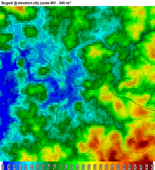
Below is the Elevation map of Bugeat, which displays elevation range with different colors. Scale of the first map is from 663 to 845 m (2175 to 2772 ft) with average elevation of 727.1 meters (=2385 ft) [note 1]
These maps also provides idea of topography and contour of this city, they are displayed at different zoom levels. More info about maps, scale and edge coordinates you can find below images.
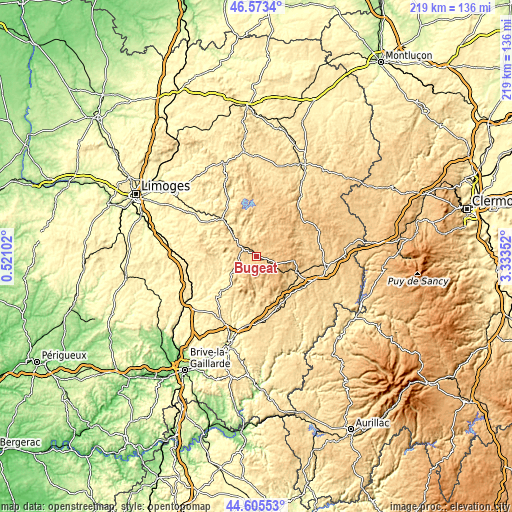
| \ | Map #1 | Topo.Map |
| Scale [m] | 663..845 m | × |
| Scale [ft] | 2175..2772 ft | × |
| Average | 727.1 m = 2385 ft | × |
| Width | 6.84 km = 4.3 mi | 218.8 km = 136 mi |
| Height | 6.84 km = 4.3 mi | 218.8 km = 136 mi |
| ↑Max Latitude | 45.62883° | 46.5734° |
| Latitude at center | 45.59809° | 45.59809° |
| ↓Min Latitude | 45.567334° | 44.60553° |
| ← Min Longitude | 1.883325° | 0.52102° |
| Longitude center | 1.92727° | 1.92727° |
| →Max Longitude | 1.971215° | 3.33352° |
Nearby cities:
Cities around Bugeat sort by population:
• Ussel elevation 629 m
30.2 km,  100°
100°
• Égletons 612 m
23.2 km,  156°
156°
• Meymac 669 m
18.5 km,  112°
112°
• Eymoutiers 423 m
21.3 km,  317°
317°
• Châteauneuf-la-Forêt 388 m
28.1 km,  297°
297°
• Treignac 491 m
12.3 km,  236°
236°
• Chamberet 408 m
16.2 km,  264°
264°
• Corrèze 477 m
25.4 km,  189°
189°
• Chamboulive 433 m
25.3 km,  223°
223°
• Peyrat-le-Château 453 m
26.8 km,  333°
333°
• La Courtine 774 m
28.5 km,  66°
66°
• Neuvic-Entier 411 m
28.1 km, 299°
Multilingual:
 En español:
Bugeat elevación 740 m.
 En France:
Bugeat élévation 740 m.


Sources and notes:
- [note 1] Map square and city borders are not equal. Map elevation data is calculated only from area inside that square.
- [src 1] Elevation data from geonames database provided with same terms of usage.
- [src 2] The elevation map of Bugeat is generated using elevation data from NASA's 3 arcsec (90m) resolution SRTM data.
- [src 3] Base (background) map © OpenStreetMap contributors tiles are generated by Geofabrik and OpenTopoMap.
Copyright & License:
This Bugeat Elevation Map is licensed under CC BY-SA. You may reuse any part from this page, if you give a proper credit by linking to this URL:
 More info on terms of use page.