La Bourboule elevation
La Bourboule (Auvergne-Rhône-Alpes, Département du Puy-de-Dôme), France elevation is 855 meters and La Bourboule elevation in feet is 2805 ft above sea level [src 1]. La Bourboule is a populated place (feature code) with elevation that is 681 meters (2234 ft) bigger than average city elevation in France.
Below is the Elevation map of La Bourboule, which displays elevation range with different colors. Scale of the first map is from 790 to 1475 m (2592 to 4839 ft) with average elevation of 1081.8 meters (=3549 ft) [note 1]
These maps also provides idea of topography and contour of this city, they are displayed at different zoom levels. More info about maps, scale and edge coordinates you can find below images.
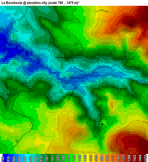
| \ | Map #1 | Topo.Map |
| Scale [m] | 790..1475 m | × |
| Scale [ft] | 2592..4839 ft | × |
| Average | 1081.8 m = 3549 ft | × |
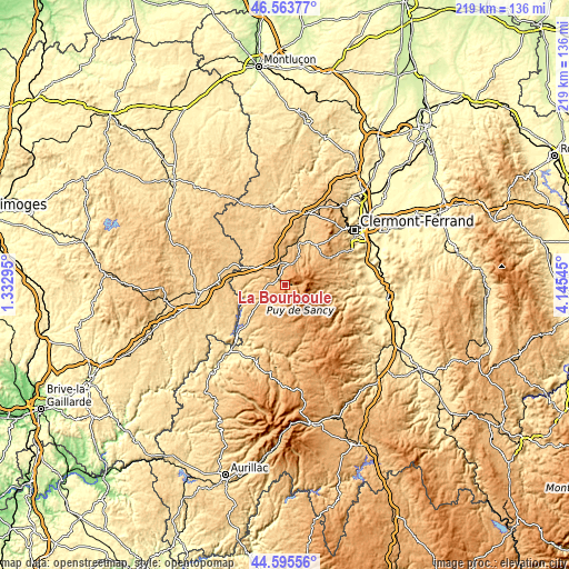
| Width | 6.84 km = 4.3 mi | 218.8 km = 136 mi |
| Height | 6.84 km = 4.3 mi | 218.8 km = 136 mi |
| ↑Max Latitude | 45.619035° | 46.56377° |
| Latitude at center | 45.58829° | 45.58829° |
| ↓Min Latitude | 45.557528° | 44.59556° |
| ← Min Longitude | 2.695255° | 1.33295° |
| Longitude center | 2.7392° | 2.7392° |
| →Max Longitude | 2.783145° | 4.14545° |
Nearby cities:
Cities around La Bourboule sort by population:
• Bort-les-Orgues elevation 492 m
28.3 km,  222°
222°
• Saint-Genès-Champanelle 862 m
26.2 km,  55°
55°
• Mont-Dore 1255 m
5.6 km,  103°
103°
• Aydat 860 m
19.9 km,  66°
66°
• Besse-et-Saint-Anastaise 1042 m
17.1 km,  117°
117°
• Lanobre 683 m
23 km, 223°
• Messeix 777 m
15.7 km,  281°
281°
• Condat 727 m
27.5 km,  176°
176°
• Saint-Sauves-d'Auvergne 888 m
4.5 km,  286°
286°
• Saint-Saturnin 506 m
28.6 km, 73°
• Champs-sur-Tarentaine-Marchal 538 m
24.9 km,  212°
212°
• Gelles 858 m
20.2 km,  5°
5°
Multilingual:
 En español:
La Bourboule elevación 855 m.
 En France:
La Bourboule élévation 855 m.
 Auf Deutsch:
La Bourboule höhe über dem Meeresspiegel ist 855 m.

Sources and notes:
- [note 1] Map square and city borders are not equal. Map elevation data is calculated only from area inside that square.
- [src 1] Elevation data from geonames database provided with same terms of usage.
- [src 2] The elevation map of La Bourboule is generated using elevation data from NASA's 3 arcsec (90m) resolution SRTM data.
- [src 3] Base (background) map © OpenStreetMap contributors tiles are generated by Geofabrik and OpenTopoMap.
Copyright & License:
This La Bourboule Elevation Map is licensed under CC BY-SA. You may reuse any part from this page, if you give a proper credit by linking to this URL:
 More info on terms of use page.