Gelles elevation
Gelles (Auvergne-Rhône-Alpes, Département du Puy-de-Dôme), France elevation is 858 meters and Gelles elevation in feet is 2815 ft above sea level [src 1]. Gelles is a populated place (feature code) with elevation that is 684 meters (2244 ft) bigger than average city elevation in France.
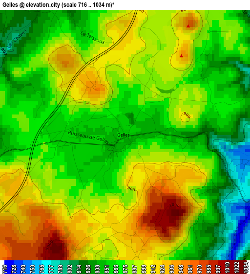
Below is the Elevation map of Gelles, which displays elevation range with different colors. Scale of the first map is from 716 to 1034 m (2349 to 3392 ft) with average elevation of 879.7 meters (=2886 ft) [note 1]
These maps also provides idea of topography and contour of this city, they are displayed at different zoom levels. More info about maps, scale and edge coordinates you can find below images.
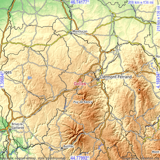
| \ | Map #1 | Topo.Map |
| Scale [m] | 716..1034 m | × |
| Scale [ft] | 2349..3392 ft | × |
| Average | 879.7 m = 2886 ft | × |
| Width | 6.82 km = 4.2 mi | 218.1 km = 135.5 mi |
| Height | 6.82 km = 4.2 mi | 218.1 km = 135.5 mi |
| ↑Max Latitude | 45.800115° | 46.74177° |
| Latitude at center | 45.76947° | 45.76947° |
| ↓Min Latitude | 45.738808° | 44.77992° |
| ← Min Longitude | 2.719145° | 1.35684° |
| Longitude center | 2.76309° | 2.76309° |
| →Max Longitude | 2.807035° | 4.16934° |
Nearby cities:
Cities around Gelles sort by population:
• Royat elevation 521 m
22.3 km,  91°
91°
• Orcines 773 m
19.4 km, 85°
• Saint-Genès-Champanelle 862 m
20.6 km,  105°
105°
• Saint-Georges-de-Mons 732 m
19.8 km,  17°
17°
• La Bourboule 855 m
20.2 km,  185°
185°
• Durtol 517 m
22.6 km,  82°
82°
• Les Ancizes 695 m
17.7 km,  12°
12°
• Mont-Dore 1255 m
21.8 km,  170°
170°
• Aydat 860 m
20.3 km,  126°
126°
• Saint-Ours 812 m
13.4 km,  47°
47°
• Saint-Sauves-d'Auvergne 888 m
19.8 km,  198°
198°
• Chapdes-Beaufort 789 m
15.8 km,  29°
29°
Multilingual:
 En español:
Gelles elevación 858 m.
 En France:
Gelles élévation 858 m.


Sources and notes:
- [note 1] Map square and city borders are not equal. Map elevation data is calculated only from area inside that square.
- [src 1] Elevation data from geonames database provided with same terms of usage.
- [src 2] The elevation map of Gelles is generated using elevation data from NASA's 3 arcsec (90m) resolution SRTM data.
- [src 3] Base (background) map © OpenStreetMap contributors tiles are generated by Geofabrik and OpenTopoMap.
Copyright & License:
This Gelles Elevation Map is licensed under CC BY-SA. You may reuse any part from this page, if you give a proper credit by linking to this URL:
 More info on terms of use page.