La Tronche elevation
La Tronche (Auvergne-Rhône-Alpes, Département de l'Isère), France elevation is 222 meters and La Tronche elevation in feet is 728 ft above sea level [src 1]. La Tronche is a populated place (feature code) with elevation that is 48 meters (157 ft) bigger than average city elevation in France.
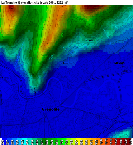
Below is the Elevation map of La Tronche, which displays elevation range with different colors. Scale of the first map is from 206 to 1282 m (676 to 4206 ft) with average elevation of 381.1 meters (=1250 ft) [note 1]
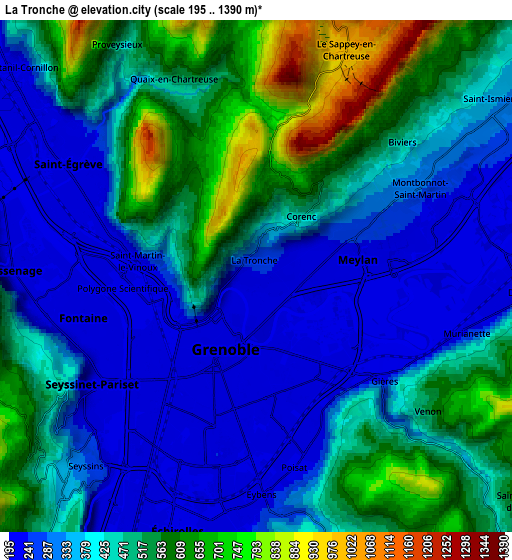
These maps also provides idea of topography and contour of this city, they are displayed at different zoom levels. More info about maps, scale and edge coordinates you can find below images.
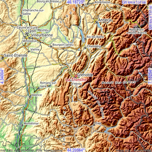
| \ | Map #1 | Map #2 | Topo.Map |
| Scale [m] | 206..1282 m | 195..1390 m | × |
| Scale [ft] | 676..4206 ft | 640..4560 ft | × |
| Average | 381.1 m = 1250 ft | 435.3 m = 1428 ft | × |
| Width | 6.89 km = 4.3 mi | 13.77 km = 8.6 mi | 220.3 km = 136.9 mi |
| Height | 6.89 km = 4.3 mi | 13.77 km = 8.6 mi | 220.3 km = 136.9 mi |
| ↑Max Latitude | 45.236024° | 45.266962° | 46.18725° |
| Latitude at center | 45.20507° | 45.20507° | 45.20507° |
| ↓Min Latitude | 45.174099° | 45.143111° | 44.20564° |
| ← Min Longitude | 5.702345° | 5.658399° | 4.34004° |
| Longitude center | 5.74629° | 5.74629° | 5.74629° |
| →Max Longitude | 5.790235° | 5.834181° | 7.15254° |
Nearby cities:
Cities around La Tronche sort by population:
• Grenoble elevation 213 m
3.8 km,  220°
220°
• Saint-Martin-d’Hères 207 m
3.2 km,  156°
156°
• Fontaine 210 m
4.8 km,  253°
253°
• Meylan 233 m
2.5 km,  77°
77°
• Saint-Égrève 214 m
6 km,  301°
301°
• Seyssinet-Pariset 222 m
5.2 km,  232°
232°
• Gières 331 m
4.4 km,  129°
129°
• Saint-Martin-le-Vinoux 257 m
2.4 km,  264°
264°
• Montbonnot-Saint-Martin 263 m
4.9 km,  62°
62°
• Corenc 401 m
2.1 km,  43°
43°
• Biviers 363 m
5.3 km,  53°
53°
• Poisat 281 m
5.3 km,  167°
167°
Multilingual:
 En español:
La Tronche elevación 222 m.
 En France:
La Tronche élévation 222 m.
 Auf Deutsch:
La Tronche höhe über dem Meeresspiegel ist 222 m.

Sources and notes:
- [note 1] Map square and city borders are not equal. Map elevation data is calculated only from area inside that square.
- [src 1] Elevation data from geonames database provided with same terms of usage.
- [src 2] The elevation map of La Tronche is generated using elevation data from NASA's 3 arcsec (90m) resolution SRTM data.
- [src 3] Base (background) map © OpenStreetMap contributors tiles are generated by Geofabrik and OpenTopoMap.
Copyright & License:
This La Tronche Elevation Map is licensed under CC BY-SA. You may reuse any part from this page, if you give a proper credit by linking to this URL:
 More info on terms of use page.