Grenoble elevation
Grenoble (Auvergne-Rhône-Alpes, Département de l'Isère), France elevation is 213 meters and Grenoble elevation in feet is 699 ft above sea level [src 1]. Grenoble is a seat of a second-order administrative division (feature code) with elevation that is 39 meters (128 ft) bigger than average city elevation in France.
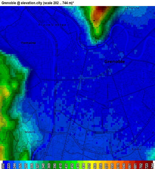
Below is the Elevation map of Grenoble, which displays elevation range with different colors. Scale of the first map is from 202 to 744 m (663 to 2441 ft) with average elevation of 248.3 meters (=815 ft) [note 1]
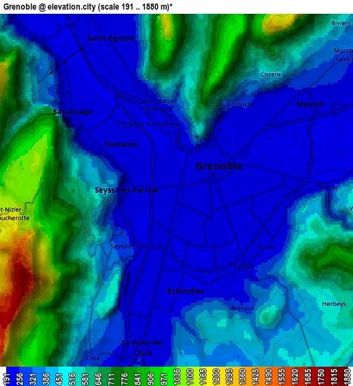
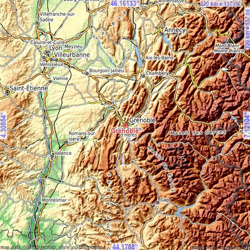
These maps also provides idea of topography and contour of this city, they are displayed at different zoom levels. More info about maps, scale and edge coordinates you can find below images.
| \ | Map #1 | Map #2 | Topo.Map |
| Scale [m] | 202..744 m | 191..1880 m | × |
| Scale [ft] | 663..2441 ft | 627..6168 ft | × |
| Average | 248.3 m = 815 ft | 461.6 m = 1514 ft | × |
| Width | 6.89 km = 4.3 mi | 13.78 km = 8.6 mi | 220.4 km = 136.9 mi |
| Height | 6.89 km = 4.3 mi | 13.78 km = 8.6 mi | 220.4 km = 136.9 mi |
| ↑Max Latitude | 45.209659° | 45.24061° | 46.16133° |
| Latitude at center | 45.17869° | 45.17869° | 45.17869° |
| ↓Min Latitude | 45.147705° | 45.116702° | 44.1788° |
| ← Min Longitude | 5.670845° | 5.626899° | 4.30854° |
| Longitude center | 5.71479° | 5.71479° | 5.71479° |
| →Max Longitude | 5.758735° | 5.802681° | 7.12104° |
Nearby cities:
Cities around Grenoble sort by population:
• Saint-Martin-d’Hères elevation 207 m
3.8 km,  89°
89°
• Échirolles 230 m
3.6 km,  180°
180°
• Fontaine 210 m
2.6 km,  306°
306°
• Seyssinet-Pariset 222 m
1.7 km,  262°
262°
• Sassenage 206 m
5.5 km, 312°
• Eybens 320 m
4.4 km,  141°
141°
• Seyssins 226 m
2.9 km,  230°
230°
• La Tronche 222 m
3.8 km,  40°
40°
• Gières 331 m
5.8 km, 88°
• Saint-Martin-le-Vinoux 257 m
2.7 km,  2°
2°
• Corenc 401 m
6 km, 41°
• Poisat 281 m
4.2 km,  122°
122°
Multilingual:
 En español:
Grenoble elevación 213 m.
 En France:
Grenoble élévation 213 m.
 Auf Deutsch:
Grenoble höhe über dem Meeresspiegel ist 213 m.
 На русском:
Грeнобль, Гренобль высота над уровнем моря 213 м
Sources and notes:
- [note 1] Map square and city borders are not equal. Map elevation data is calculated only from area inside that square.
- [src 1] Elevation data from geonames database provided with same terms of usage.
- [src 2] The elevation map of Grenoble is generated using elevation data from NASA's 3 arcsec (90m) resolution SRTM data.
- [src 3] Base (background) map © OpenStreetMap contributors tiles are generated by Geofabrik and OpenTopoMap.
Copyright & License:
This Grenoble Elevation Map is licensed under CC BY-SA. You may reuse any part from this page, if you give a proper credit by linking to this URL:
 More info on terms of use page.