Saint-Égrève elevation
Saint-Égrève (Auvergne-Rhône-Alpes, Département de l'Isère), France elevation is 214 meters and Saint-Égrève elevation in feet is 702 ft above sea level [src 1]. Saint-Égrève is a populated place (feature code) with elevation that is 40 meters (131 ft) bigger than average city elevation in France.
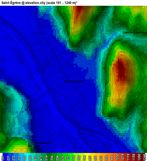
Below is the Elevation map of Saint-Égrève, which displays elevation range with different colors. Scale of the first map is from 191 to 1240 m (627 to 4068 ft) with average elevation of 381.5 meters (=1252 ft) [note 1]
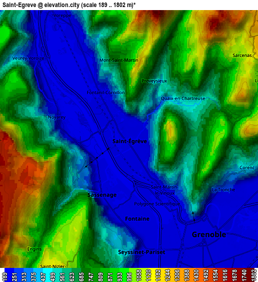
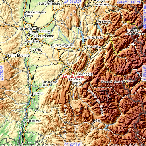
These maps also provides idea of topography and contour of this city, they are displayed at different zoom levels. More info about maps, scale and edge coordinates you can find below images.
| \ | Map #1 | Map #2 | Topo.Map |
| Scale [m] | 191..1240 m | 189..1802 m | × |
| Scale [ft] | 627..4068 ft | 620..5912 ft | × |
| Average | 381.5 m = 1252 ft | 628.7 m = 2063 ft | × |
| Width | 6.88 km = 4.3 mi | 13.76 km = 8.6 mi | 220.2 km = 136.8 mi |
| Height | 6.88 km = 4.3 mi | 13.76 km = 8.6 mi | 220.2 km = 136.8 mi |
| ↑Max Latitude | 45.264069° | 45.294991° | 46.21482° |
| Latitude at center | 45.23313° | 45.23313° | 45.23313° |
| ↓Min Latitude | 45.202174° | 45.171202° | 44.23419° |
| ← Min Longitude | 5.637595° | 5.593649° | 4.27529° |
| Longitude center | 5.68154° | 5.68154° | 5.68154° |
| →Max Longitude | 5.725485° | 5.769431° | 7.08779° |
Nearby cities:
Cities around Saint-Égrève sort by population:
• Grenoble elevation 213 m
6.6 km,  156°
156°
• Fontaine 210 m
4.5 km,  173°
173°
• Seyssinet-Pariset 222 m
6.3 km, 171°
• Sassenage 206 m
2.7 km,  212°
212°
• Voreppe 235 m
7.9 km,  330°
330°
• Seyssins 226 m
7.9 km,  177°
177°
• La Tronche 222 m
6 km,  121°
121°
• Saint-Martin-le-Vinoux 257 m
4.3 km,  140°
140°
• Corenc 401 m
6.7 km,  103°
103°
• Fontanil-Cornillon 289 m
2.6 km, 326°
• Noyarey 199 m
3.9 km,  288°
288°
• Veurey-Voroize 233 m
6.9 km,  309°
309°
Multilingual:
 En español:
San Egreve elevación 214 m.
 En France:
Saint-Égrève, Sainte-Égrève élévation 214 m.
 Auf Deutsch:
Saint-Égrève höhe über dem Meeresspiegel ist 214 m.

Sources and notes:
- [note 1] Map square and city borders are not equal. Map elevation data is calculated only from area inside that square.
- [src 1] Elevation data from geonames database provided with same terms of usage.
- [src 2] The elevation map of Saint-Égrève is generated using elevation data from NASA's 3 arcsec (90m) resolution SRTM data.
- [src 3] Base (background) map © OpenStreetMap contributors tiles are generated by Geofabrik and OpenTopoMap.
Copyright & License:
This Saint-Égrève Elevation Map is licensed under CC BY-SA. You may reuse any part from this page, if you give a proper credit by linking to this URL:
 More info on terms of use page.