Meyreuil elevation
Meyreuil (Provence-Alpes-Côte d'Azur, Département des Bouches-du-Rhône), France elevation is 256 meters and Meyreuil elevation in feet is 840 ft above sea level [src 1]. Meyreuil is a populated place (feature code) with elevation that is 82 meters (269 ft) bigger than average city elevation in France.
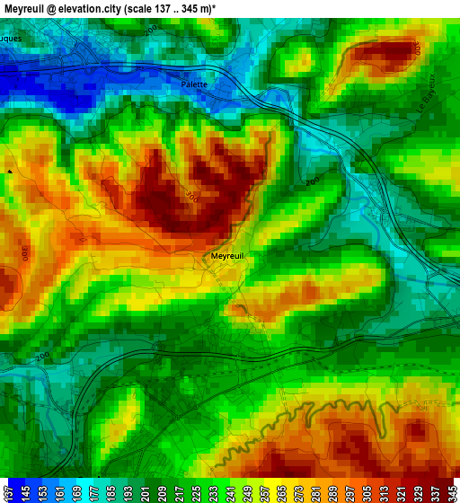
Below is the Elevation map of Meyreuil, which displays elevation range with different colors. Scale of the first map is from 137 to 345 m (449 to 1132 ft) with average elevation of 233.5 meters (=766 ft) [note 1]
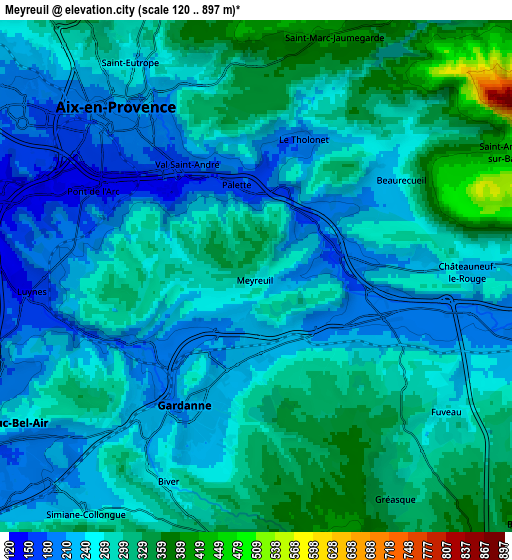
These maps also provides idea of topography and contour of this city, they are displayed at different zoom levels. More info about maps, scale and edge coordinates you can find below images.
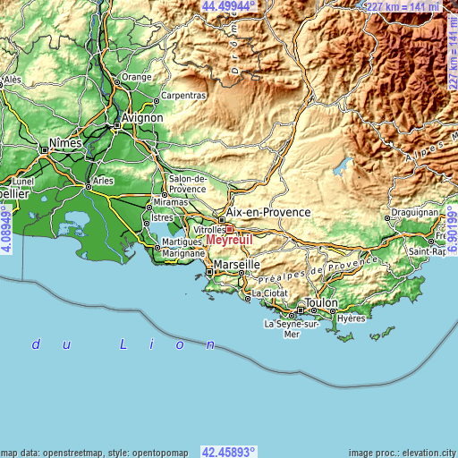
| \ | Map #1 | Map #2 | Topo.Map |
| Scale [m] | 137..345 m | 120..897 m | × |
| Scale [ft] | 449..1132 ft | 394..2943 ft | × |
| Average | 233.5 m = 766 ft | 268.9 m = 882 ft | × |
| Width | 7.09 km = 4.4 mi | 14.18 km = 8.8 mi | 226.9 km = 141 mi |
| Height | 7.09 km = 4.4 mi | 14.18 km = 8.8 mi | 226.9 km = 141 mi |
| ↑Max Latitude | 43.519675° | 43.551533° | 44.49944° |
| Latitude at center | 43.4878° | 43.4878° | 43.4878° |
| ↓Min Latitude | 43.455908° | 43.424° | 42.45893° |
| ← Min Longitude | 5.451795° | 5.407849° | 4.08949° |
| Longitude center | 5.49574° | 5.49574° | 5.49574° |
| →Max Longitude | 5.539685° | 5.583631° | 6.90199° |
Nearby cities:
Cities around Meyreuil sort by population:
• Aix-en-Provence elevation 205 m
5.8 km,  320°
320°
• Gardanne 216 m
4.2 km,  210°
210°
• Bouc-Bel-Air 253 m
7.8 km,  239°
239°
• Fuveau 257 m
6.4 km,  123°
123°
• Simiane-Collongue 229 m
8 km,  217°
217°
• Mimet 497 m
8.2 km,  174°
174°
• Rousset 264 m
10 km,  93°
93°
• Gréasque 312 m
7.2 km,  147°
147°
• Saint-Savournin 432 m
9.2 km,  164°
164°
• Le Tholonet 184 m
4 km,  18°
18°
• Châteauneuf-le-Rouge 230 m
5.9 km, 88°
• Saint-Marc-Jaumegarde 380 m
7 km, 18°
Multilingual:
 En español:
Meyreuil elevación 256 m.
 En France:
Meyreuil élévation 256 m.
 Auf Deutsch:
Meyreuil höhe über dem Meeresspiegel ist 256 m.

Sources and notes:
- [note 1] Map square and city borders are not equal. Map elevation data is calculated only from area inside that square.
- [src 1] Elevation data from geonames database provided with same terms of usage.
- [src 2] The elevation map of Meyreuil is generated using elevation data from NASA's 3 arcsec (90m) resolution SRTM data.
- [src 3] Base (background) map © OpenStreetMap contributors tiles are generated by Geofabrik and OpenTopoMap.
Copyright & License:
This Meyreuil Elevation Map is licensed under CC BY-SA. You may reuse any part from this page, if you give a proper credit by linking to this URL:
 More info on terms of use page.