Mimet elevation
Mimet (Provence-Alpes-Côte d'Azur, Département des Bouches-du-Rhône), France elevation is 497 meters and Mimet elevation in feet is 1631 ft above sea level [src 1]. Mimet is a populated place (feature code) with elevation that is 323 meters (1060 ft) bigger than average city elevation in France.
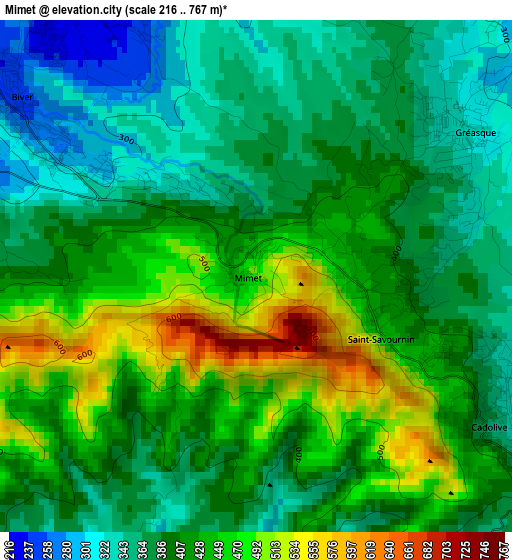
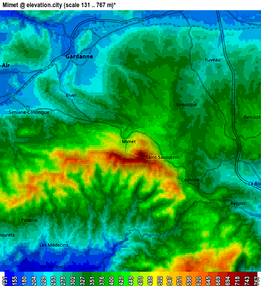
Below is the Elevation map of Mimet, which displays elevation range with different colors. Scale of the first map is from 216 to 767 m (709 to 2516 ft) with average elevation of 408 meters (=1339 ft) [note 1]
These maps also provides idea of topography and contour of this city, they are displayed at different zoom levels. More info about maps, scale and edge coordinates you can find below images.
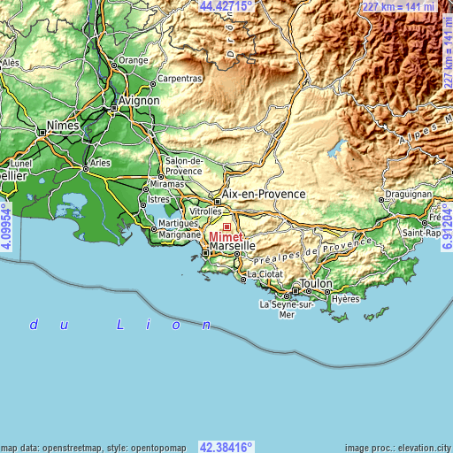
| \ | Map #1 | Map #2 | Topo.Map |
| Scale [m] | 216..767 m | 131..767 m | × |
| Scale [ft] | 709..2516 ft | 430..2516 ft | × |
| Average | 408 m = 1339 ft | 332.5 m = 1091 ft | × |
| Width | 7.1 km = 4.4 mi | 14.2 km = 8.8 mi | 227.2 km = 141.2 mi |
| Height | 7.1 km = 4.4 mi | 14.2 km = 8.8 mi | 227.2 km = 141.2 mi |
| ↑Max Latitude | 43.446184° | 43.47808° | 44.42715° |
| Latitude at center | 43.41427° | 43.41427° | 43.41427° |
| ↓Min Latitude | 43.38234° | 43.350392° | 42.38416° |
| ← Min Longitude | 5.461845° | 5.417899° | 4.09954° |
| Longitude center | 5.50579° | 5.50579° | 5.50579° |
| →Max Longitude | 5.549735° | 5.593681° | 6.91204° |
Nearby cities:
Cities around Mimet sort by population:
• Gardanne elevation 216 m
5.4 km,  326°
326°
• Plan-de-Cuques 133 m
8.2 km,  204°
204°
• Fuveau 257 m
6.4 km,  44°
44°
• Simiane-Collongue 229 m
6 km,  287°
287°
• Peypin 291 m
6.7 km,  119°
119°
• La Bouilladisse 242 m
7.3 km,  105°
105°
• Gréasque 312 m
3.8 km,  56°
56°
• Saint-Savournin 432 m
1.8 km, 110°
• Palama 239 m
7.3 km,  222°
222°
• Cadolive 367 m
3.7 km, 121°
• Belcodène 396 m
6.8 km,  78°
78°
• Les Médecins 162 m
7.8 km,  211°
211°
Multilingual:
 En español:
Mimet elevación 497 m.
 En France:
Mimet élévation 497 m.


Sources and notes:
- [note 1] Map square and city borders are not equal. Map elevation data is calculated only from area inside that square.
- [src 1] Elevation data from geonames database provided with same terms of usage.
- [src 2] The elevation map of Mimet is generated using elevation data from NASA's 3 arcsec (90m) resolution SRTM data.
- [src 3] Base (background) map © OpenStreetMap contributors tiles are generated by Geofabrik and OpenTopoMap.
Copyright & License:
This Mimet Elevation Map is licensed under CC BY-SA. You may reuse any part from this page, if you give a proper credit by linking to this URL:
 More info on terms of use page.