Rousset elevation
Rousset (Provence-Alpes-Côte d'Azur, Département des Bouches-du-Rhône), France elevation is 264 meters and Rousset elevation in feet is 866 ft above sea level [src 1]. Rousset is a populated place (feature code) with elevation that is 90 meters (295 ft) bigger than average city elevation in France.
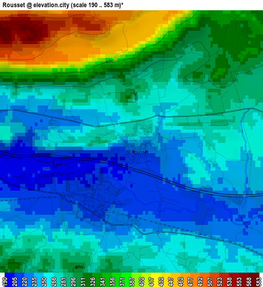
Below is the Elevation map of Rousset, which displays elevation range with different colors. Scale of the first map is from 190 to 583 m (623 to 1913 ft) with average elevation of 285.8 meters (=938 ft) [note 1]
These maps also provides idea of topography and contour of this city, they are displayed at different zoom levels. More info about maps, scale and edge coordinates you can find below images.
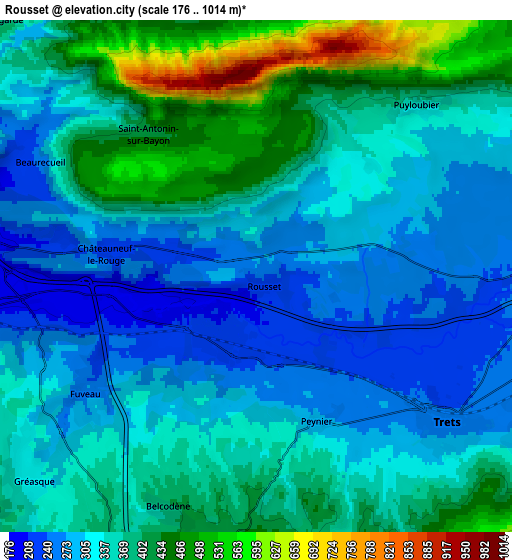
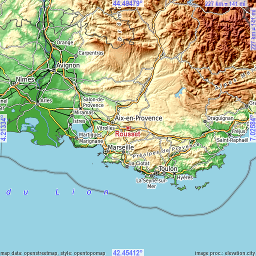
| \ | Map #1 | Map #2 | Topo.Map |
| Scale [m] | 190..583 m | 176..1014 m | × |
| Scale [ft] | 623..1913 ft | 577..3327 ft | × |
| Average | 285.8 m = 938 ft | 348.6 m = 1144 ft | × |
| Width | 7.09 km = 4.4 mi | 14.18 km = 8.8 mi | 226.9 km = 141 mi |
| Height | 7.09 km = 4.4 mi | 14.18 km = 8.8 mi | 226.9 km = 141 mi |
| ↑Max Latitude | 43.514947° | 43.546808° | 44.49479° |
| Latitude at center | 43.48307° | 43.48307° | 43.48307° |
| ↓Min Latitude | 43.451176° | 43.419265° | 42.45412° |
| ← Min Longitude | 5.575645° | 5.531699° | 4.21334° |
| Longitude center | 5.61959° | 5.61959° | 5.61959° |
| →Max Longitude | 5.663535° | 5.707481° | 7.02584° |
Nearby cities:
Cities around Rousset sort by population:
• Trets elevation 247 m
6.4 km,  127°
127°
• Fuveau 257 m
5.6 km,  237°
237°
• La Bouilladisse 242 m
9.9 km,  192°
192°
• Meyreuil 256 m
10 km,  273°
273°
• Pourrières 304 m
9.6 km,  74°
74°
• Gréasque 312 m
8.2 km,  227°
227°
• Peynier 272 m
4.2 km,  155°
155°
• Le Tholonet 184 m
9.7 km,  296°
296°
• Châteauneuf-le-Rouge 230 m
4.1 km,  279°
279°
• Puyloubier 350 m
6.6 km,  44°
44°
• Belcodène 396 m
6.8 km,  201°
201°
• Saint-Marc-Jaumegarde 380 m
10.6 km,  312°
312°
Multilingual:
 En español:
Rousset elevación 264 m.
 En France:
Rousset élévation 264 m.


Sources and notes:
- [note 1] Map square and city borders are not equal. Map elevation data is calculated only from area inside that square.
- [src 1] Elevation data from geonames database provided with same terms of usage.
- [src 2] The elevation map of Rousset is generated using elevation data from NASA's 3 arcsec (90m) resolution SRTM data.
- [src 3] Base (background) map © OpenStreetMap contributors tiles are generated by Geofabrik and OpenTopoMap.
Copyright & License:
This Rousset Elevation Map is licensed under CC BY-SA. You may reuse any part from this page, if you give a proper credit by linking to this URL:
 More info on terms of use page.