Nancray elevation
Nancray (Bourgogne-Franche-Comté, Doubs), France elevation is 410 meters and Nancray elevation in feet is 1345 ft above sea level [src 1]. Nancray is a populated place (feature code) with elevation that is 236 meters (774 ft) bigger than average city elevation in France.
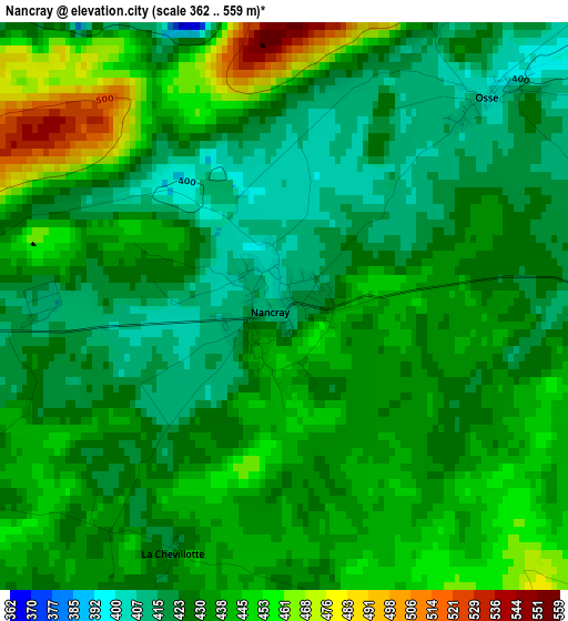
Below is the Elevation map of Nancray, which displays elevation range with different colors. Scale of the first map is from 362 to 559 m (1188 to 1834 ft) with average elevation of 433.6 meters (=1423 ft) [note 1]
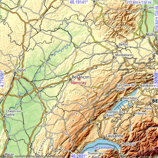
These maps also provides idea of topography and contour of this city, they are displayed at different zoom levels. More info about maps, scale and edge coordinates you can find below images.
| \ | Map #1 | Topo.Map |
| Scale [m] | 362..559 m | × |
| Scale [ft] | 1188..1834 ft | × |
| Average | 433.6 m = 1423 ft | × |
| Width | 6.63 km = 4.1 mi | 212.3 km = 131.9 mi |
| Height | 6.63 km = 4.1 mi | 212.3 km = 131.9 mi |
| ↑Max Latitude | 47.275184° | 48.19141° |
| Latitude at center | 47.24536° | 47.24536° |
| ↓Min Latitude | 47.215519° | 46.2821° |
| ← Min Longitude | 6.138885° | 4.77658° |
| Longitude center | 6.18283° | 6.18283° |
| →Max Longitude | 6.226775° | 7.58908° |
Nearby cities:
Cities around Nancray sort by population:
• Besançon elevation 300 m
12.4 km,  271°
271°
• Thise 278 m
8.8 km,  299°
299°
• Saône 401 m
5.6 km,  243°
243°
• Roche-lez-Beaupré 264 m
6.5 km,  310°
310°
• Châtillon-le-Duc 424 m
14.8 km, 296°
• Mamirolle 469 m
5.5 km,  198°
198°
• Novillars 264 m
6 km,  316°
316°
• Montfaucon 522 m
7.7 km,  261°
261°
• Beure 251 m
14.1 km,  252°
252°
• Morre 451 m
8.4 km, 255°
• Roulans 347 m
8.5 km,  24°
24°
• Étalans 596 m
12.5 km,  146°
146°
Multilingual:
 En español:
Nancray elevación 410 m.
 En France:
Nancray élévation 410 m.


Sources and notes:
- [note 1] Map square and city borders are not equal. Map elevation data is calculated only from area inside that square.
- [src 1] Elevation data from geonames database provided with same terms of usage.
- [src 2] The elevation map of Nancray is generated using elevation data from NASA's 3 arcsec (90m) resolution SRTM data.
- [src 3] Base (background) map © OpenStreetMap contributors tiles are generated by Geofabrik and OpenTopoMap.
Copyright & License:
This Nancray Elevation Map is licensed under CC BY-SA. You may reuse any part from this page, if you give a proper credit by linking to this URL:
 More info on terms of use page.