Besançon elevation
Besançon (Bourgogne-Franche-Comté, Doubs), France elevation is 300 meters and Besançon elevation in feet is 984 ft above sea level [src 1]. Besançon is a seat of a second-order administrative division (feature code) with elevation that is 126 meters (413 ft) bigger than average city elevation in France.
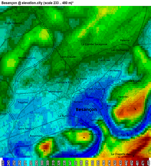
Below is the Elevation map of Besançon, which displays elevation range with different colors. Scale of the first map is from 233 to 480 m (764 to 1575 ft) with average elevation of 309.6 meters (=1016 ft) [note 1]
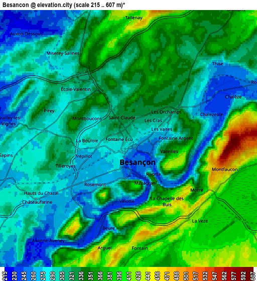
These maps also provides idea of topography and contour of this city, they are displayed at different zoom levels. More info about maps, scale and edge coordinates you can find below images.

| \ | Map #1 | Map #2 | Topo.Map |
| Scale [m] | 233..480 m | 215..607 m | × |
| Scale [ft] | 764..1575 ft | 705..1991 ft | × |
| Average | 309.6 m = 1016 ft | 330.3 m = 1084 ft | × |
| Width | 6.63 km = 4.1 mi | 13.27 km = 8.2 mi | 212.3 km = 131.9 mi |
| Height | 6.63 km = 4.1 mi | 13.27 km = 8.2 mi | 212.3 km = 131.9 mi |
| ↑Max Latitude | 47.278602° | 47.308408° | 48.19477° |
| Latitude at center | 47.24878° | 47.24878° | 47.24878° |
| ↓Min Latitude | 47.218941° | 47.189085° | 46.28559° |
| ← Min Longitude | 5.974205° | 5.930259° | 4.6119° |
| Longitude center | 6.01815° | 6.01815° | 6.01815° |
| →Max Longitude | 6.062095° | 6.106041° | 7.4244° |
Nearby cities:
Cities around Besançon sort by population:
• Thise elevation 278 m
6.2 km,  49°
49°
• École-Valentin 300 m
3.3 km,  307°
307°
• Miserey-Salines 287 m
5.4 km,  321°
321°
• Avanne-Aveney 234 m
6.7 km,  215°
215°
• Châtillon-le-Duc 424 m
6.3 km,  352°
352°
• Pouilley-les-Vignes 235 m
6.3 km,  279°
279°
• Franois 269 m
7.1 km,  253°
253°
• Serre-les-Sapins 280 m
6.4 km,  271°
271°
• Pirey 299 m
4.3 km,  289°
289°
• Montfaucon 522 m
5 km,  106°
106°
• Beure 251 m
4.8 km,  191°
191°
• Morre 451 m
5 km,  120°
120°
Multilingual:
 En español:
Besanzón elevación 300 m.
 En France:
Besançon élévation 300 m.
 Auf Deutsch:
Besançon höhe über dem Meeresspiegel ist 300 m.

Sources and notes:
- [note 1] Map square and city borders are not equal. Map elevation data is calculated only from area inside that square.
- [src 1] Elevation data from geonames database provided with same terms of usage.
- [src 2] The elevation map of Besançon is generated using elevation data from NASA's 3 arcsec (90m) resolution SRTM data.
- [src 3] Base (background) map © OpenStreetMap contributors tiles are generated by Geofabrik and OpenTopoMap.
Copyright & License:
This Besançon Elevation Map is licensed under CC BY-SA. You may reuse any part from this page, if you give a proper credit by linking to this URL:
 More info on terms of use page.