Châtillon-le-Duc elevation
Châtillon-le-Duc (Bourgogne-Franche-Comté, Doubs), France elevation is 424 meters and Châtillon-le-Duc elevation in feet is 1391 ft above sea level [src 1]. Châtillon-le-Duc is a populated place (feature code) with elevation that is 250 meters (820 ft) bigger than average city elevation in France.
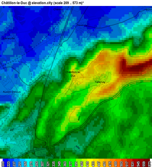
Below is the Elevation map of Châtillon-le-Duc, which displays elevation range with different colors. Scale of the first map is from 209 to 573 m (686 to 1880 ft) with average elevation of 317.9 meters (=1043 ft) [note 1]
These maps also provides idea of topography and contour of this city, they are displayed at different zoom levels. More info about maps, scale and edge coordinates you can find below images.
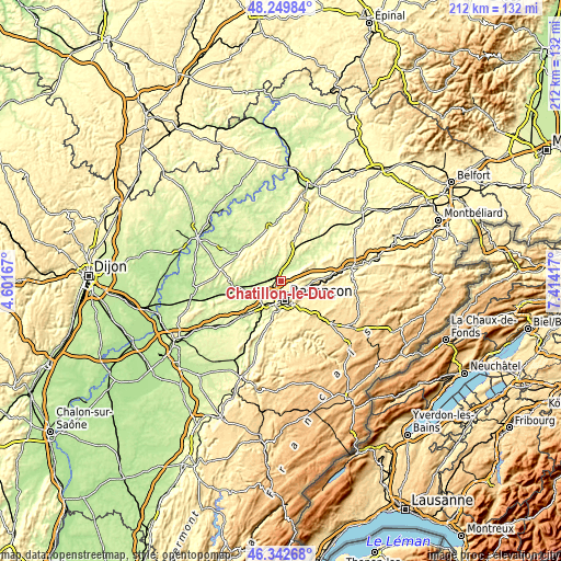
| \ | Map #1 | Topo.Map |
| Scale [m] | 209..573 m | × |
| Scale [ft] | 686..1880 ft | × |
| Average | 317.9 m = 1043 ft | × |
| Width | 6.63 km = 4.1 mi | 212.1 km = 131.8 mi |
| Height | 6.63 km = 4.1 mi | 212 km = 131.7 mi |
| ↑Max Latitude | 47.334651° | 48.24984° |
| Latitude at center | 47.30486° | 47.30486° |
| ↓Min Latitude | 47.275052° | 46.34268° |
| ← Min Longitude | 5.963975° | 4.60167° |
| Longitude center | 6.00792° | 6.00792° |
| →Max Longitude | 6.051865° | 7.41417° |
Nearby cities:
Cities around Châtillon-le-Duc sort by population:
• Besançon elevation 300 m
6.3 km,  172°
172°
• Thise 278 m
6 km,  111°
111°
• École-Valentin 300 m
4.6 km,  203°
203°
• Miserey-Salines 287 m
3.3 km,  231°
231°
• Roche-lez-Beaupré 264 m
8.5 km, 106°
• Pouilley-les-Vignes 235 m
7.6 km, 226°
• Novillars 264 m
9.4 km,  103°
103°
• Serre-les-Sapins 280 m
8.3 km,  222°
222°
• Pirey 299 m
5.8 km,  214°
214°
• Devecey 255 m
2 km,  24°
24°
• Pelousey 230 m
7.2 km,  242°
242°
• Auxon-Dessous 224 m
4.4 km,  262°
262°
Multilingual:
 En español:
Châtillon-le-Duc elevación 424 m.
 En France:
Châtillon-le-Duc élévation 424 m.
 Auf Deutsch:
Châtillon-le-Duc höhe über dem Meeresspiegel ist 424 m.

Sources and notes:
- [note 1] Map square and city borders are not equal. Map elevation data is calculated only from area inside that square.
- [src 1] Elevation data from geonames database provided with same terms of usage.
- [src 2] The elevation map of Châtillon-le-Duc is generated using elevation data from NASA's 3 arcsec (90m) resolution SRTM data.
- [src 3] Base (background) map © OpenStreetMap contributors tiles are generated by Geofabrik and OpenTopoMap.
Copyright & License:
This Châtillon-le-Duc Elevation Map is licensed under CC BY-SA. You may reuse any part from this page, if you give a proper credit by linking to this URL:
 More info on terms of use page.