Rémalard elevation
Rémalard (Normandy, Département de l'Orne), France elevation is 139 meters and Rémalard elevation in feet is 456 ft above sea level [src 1]. Rémalard is a populated place (feature code) with elevation that is 35 meters (115 ft) smaller than average city elevation in France.
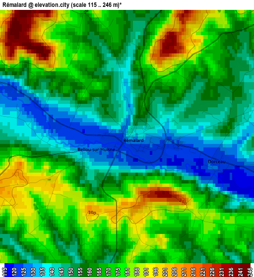
Below is the Elevation map of Rémalard, which displays elevation range with different colors. Scale of the first map is from 115 to 246 m (377 to 807 ft) with average elevation of 163.8 meters (=537 ft) [note 1]
These maps also provides idea of topography and contour of this city, they are displayed at different zoom levels. More info about maps, scale and edge coordinates you can find below images.
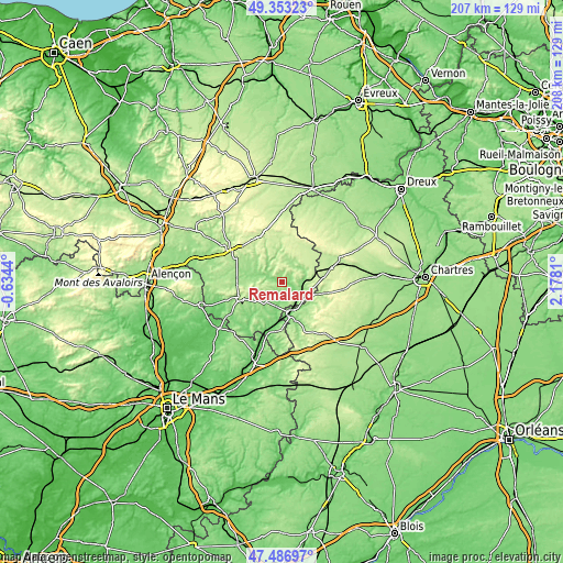
| \ | Map #1 | Topo.Map |
| Scale [m] | 115..246 m | × |
| Scale [ft] | 377..807 ft | × |
| Average | 163.8 m = 537 ft | × |
| Width | 6.48 km = 4 mi | 207.5 km = 128.9 mi |
| Height | 6.48 km = 4 mi | 207.5 km = 128.9 mi |
| ↑Max Latitude | 48.457822° | 49.35323° |
| Latitude at center | 48.42867° | 48.42867° |
| ↓Min Latitude | 48.399502° | 47.48697° |
| ← Min Longitude | 0.727905° | -0.6344° |
| Longitude center | 0.77185° | 0.77185° |
| →Max Longitude | 0.815795° | 2.1781° |
Nearby cities:
Cities around Rémalard sort by population:
• Nogent-le-Rotrou elevation 148 m
12.5 km,  162°
162°
• Mortagne-au-Perche 222 m
19.4 km,  301°
301°
• La Loupe 216 m
18.7 km,  74°
74°
• Senonches 221 m
24 km,  52°
52°
• Ceton 120 m
22.6 km,  184°
184°
• Bellême 220 m
16.1 km,  247°
247°
• Tourouvre 250 m
19.9 km,  333°
333°
• Longny-au-Perche 167 m
11.3 km,  352°
352°
• Bretoncelles 155 m
8.6 km,  88°
88°
• Margon 127 m
11.3 km, 155°
• Condé-sur-Huisne 124 m
7.9 km,  132°
132°
• Thiron Gardais 245 m
20 km, 128°
Multilingual:
 En español:
Rémalard elevación 139 m.
 En France:
Rémalard élévation 139 m.
 Auf Deutsch:
Rémalard höhe über dem Meeresspiegel ist 139 m.

Sources and notes:
- [note 1] Map square and city borders are not equal. Map elevation data is calculated only from area inside that square.
- [src 1] Elevation data from geonames database provided with same terms of usage.
- [src 2] The elevation map of Rémalard is generated using elevation data from NASA's 3 arcsec (90m) resolution SRTM data.
- [src 3] Base (background) map © OpenStreetMap contributors tiles are generated by Geofabrik and OpenTopoMap.
Copyright & License:
This Rémalard Elevation Map is licensed under CC BY-SA. You may reuse any part from this page, if you give a proper credit by linking to this URL:
 More info on terms of use page.