Bellême elevation
Bellême (Normandy, Département de l'Orne), France elevation is 220 meters and Bellême elevation in feet is 722 ft above sea level [src 1]. Bellême is a populated place (feature code) with elevation that is 46 meters (151 ft) bigger than average city elevation in France.
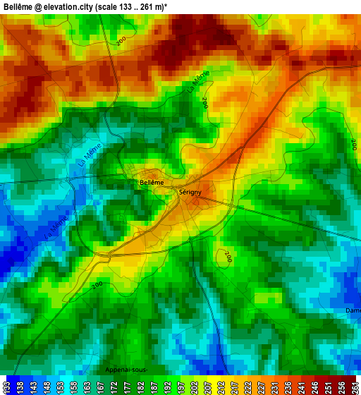
Below is the Elevation map of Bellême, which displays elevation range with different colors. Scale of the first map is from 133 to 261 m (436 to 856 ft) with average elevation of 191.9 meters (=630 ft) [note 1]
These maps also provides idea of topography and contour of this city, they are displayed at different zoom levels. More info about maps, scale and edge coordinates you can find below images.
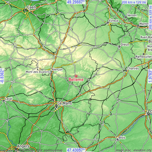
| \ | Map #1 | Topo.Map |
| Scale [m] | 133..261 m | × |
| Scale [ft] | 436..856 ft | × |
| Average | 191.9 m = 630 ft | × |
| Width | 6.49 km = 4 mi | 207.7 km = 129.1 mi |
| Height | 6.49 km = 4 mi | 207.7 km = 129.1 mi |
| ↑Max Latitude | 48.402473° | 49.29887° |
| Latitude at center | 48.37329° | 48.37329° |
| ↓Min Latitude | 48.34409° | 47.43057° |
| ← Min Longitude | 0.526105° | -0.8362° |
| Longitude center | 0.57005° | 0.57005° |
| →Max Longitude | 0.613995° | 1.9763° |
Nearby cities:
Cities around Bellême sort by population:
• Nogent-le-Rotrou elevation 148 m
19.5 km,  107°
107°
• La Ferté-Bernard 86 m
21.7 km,  163°
163°
• Mamers 138 m
15.1 km,  259°
259°
• Mortagne-au-Perche 222 m
16.4 km,  354°
354°
• Marolles-les-Braults 85 m
23.1 km,  234°
234°
• Saint-Cosme-en-Vairais 92 m
14.1 km,  212°
212°
• Ceton 120 m
21.1 km,  140°
140°
• Longny-au-Perche 167 m
22 km,  37°
37°
• Cherré 96 m
23.2 km, 163°
• Margon 127 m
20 km,  102°
102°
• Rémalard 139 m
16.1 km,  67°
67°
• Condé-sur-Huisne 124 m
20.8 km,  87°
87°
Multilingual:
 En español:
Bellême elevación 220 m.
 En France:
Bellême élévation 220 m.


Sources and notes:
- [note 1] Map square and city borders are not equal. Map elevation data is calculated only from area inside that square.
- [src 1] Elevation data from geonames database provided with same terms of usage.
- [src 2] The elevation map of Bellême is generated using elevation data from NASA's 3 arcsec (90m) resolution SRTM data.
- [src 3] Base (background) map © OpenStreetMap contributors tiles are generated by Geofabrik and OpenTopoMap.
Copyright & License:
This Bellême Elevation Map is licensed under CC BY-SA. You may reuse any part from this page, if you give a proper credit by linking to this URL:
 More info on terms of use page.