Senonches elevation
Senonches (Centre, Département d'Eure-et-Loir), France elevation is 221 meters and Senonches elevation in feet is 725 ft above sea level [src 1]. Senonches is a populated place (feature code) with elevation that is 47 meters (154 ft) bigger than average city elevation in France.
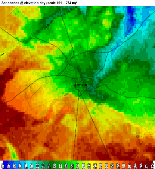
Below is the Elevation map of Senonches, which displays elevation range with different colors. Scale of the first map is from 191 to 274 m (627 to 899 ft) with average elevation of 237.7 meters (=780 ft) [note 1]
These maps also provides idea of topography and contour of this city, they are displayed at different zoom levels. More info about maps, scale and edge coordinates you can find below images.
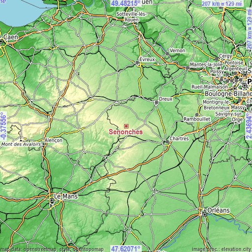
| \ | Map #1 | Topo.Map |
| Scale [m] | 191..274 m | × |
| Scale [ft] | 627..899 ft | × |
| Average | 237.7 m = 780 ft | × |
| Width | 6.47 km = 4 mi | 207 km = 128.6 mi |
| Height | 6.47 km = 4 mi | 207 km = 128.6 mi |
| ↑Max Latitude | 48.589066° | 49.48215° |
| Latitude at center | 48.55999° | 48.55999° |
| ↓Min Latitude | 48.530897° | 47.62071° |
| ← Min Longitude | 0.986745° | -0.37556° |
| Longitude center | 1.03069° | 1.03069° |
| →Max Longitude | 1.074635° | 2.43694° |
Nearby cities:
Cities around Senonches sort by population:
• Verneuil-sur-Avre elevation 176 m
21.4 km,  339°
339°
• La Loupe 216 m
9.7 km,  186°
186°
• Courville-sur-Eure 175 m
19.8 km,  128°
128°
• Châteauneuf-en-Thymerais 215 m
15.6 km,  81°
81°
• Brezolles 164 m
14.8 km,  12°
12°
• Longny-au-Perche 167 m
20.8 km,  260°
260°
• Bretoncelles 155 m
17.8 km,  216°
216°
• Tréon 111 m
25.4 km,  59°
59°
• Rémalard 139 m
24 km,  232°
232°
• Tillières-sur-Avre 135 m
21.8 km,  4°
4°
• Condé-sur-Huisne 124 m
23.9 km,  213°
213°
• Fontaine-la-Guyon 174 m
23 km,  114°
114°
Multilingual:
 En español:
Senonches elevación 221 m.
 En France:
Senonches élévation 221 m.
 Auf Deutsch:
Senonches höhe über dem Meeresspiegel ist 221 m.

Sources and notes:
- [note 1] Map square and city borders are not equal. Map elevation data is calculated only from area inside that square.
- [src 1] Elevation data from geonames database provided with same terms of usage.
- [src 2] The elevation map of Senonches is generated using elevation data from NASA's 3 arcsec (90m) resolution SRTM data.
- [src 3] Base (background) map © OpenStreetMap contributors tiles are generated by Geofabrik and OpenTopoMap.
Copyright & License:
This Senonches Elevation Map is licensed under CC BY-SA. You may reuse any part from this page, if you give a proper credit by linking to this URL:
 More info on terms of use page.