Roissy-en-France elevation
Roissy-en-France (Île-de-France, Département du Val-d’Oise), France elevation is 96 meters and Roissy-en-France elevation in feet is 315 ft above sea level [src 1]. Roissy-en-France is a populated place (feature code) with elevation that is 78 meters (256 ft) smaller than average city elevation in France.
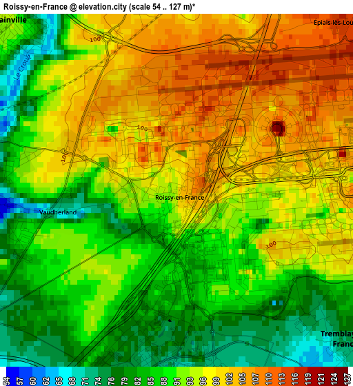
Below is the Elevation map of Roissy-en-France, which displays elevation range with different colors. Scale of the first map is from 54 to 127 m (177 to 417 ft) with average elevation of 92.8 meters (=304 ft) [note 1]
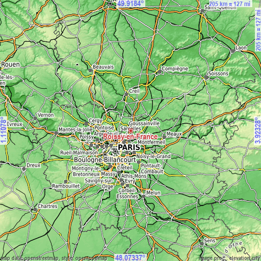
These maps also provides idea of topography and contour of this city, they are displayed at different zoom levels. More info about maps, scale and edge coordinates you can find below images.
| \ | Map #1 | Topo.Map |
| Scale [m] | 54..127 m | × |
| Scale [ft] | 177..417 ft | × |
| Average | 92.8 m = 304 ft | × |
| Width | 6.41 km = 4 mi | 205.1 km = 127.4 mi |
| Height | 6.41 km = 4 mi | 205.1 km = 127.4 mi |
| ↑Max Latitude | 49.03325° | 49.9184° |
| Latitude at center | 49.00443° | 49.00443° |
| ↓Min Latitude | 48.975594° | 48.07337° |
| ← Min Longitude | 2.473085° | 1.11078° |
| Longitude center | 2.51703° | 2.51703° |
| →Max Longitude | 2.560975° | 3.92328° |
Nearby cities:
Cities around Roissy-en-France sort by population:
• Aulnay-sous-Bois elevation 45 m
7.6 km,  192°
192°
• Sevran 55 m
6.7 km,  173°
173°
• Villepinte 57 m
4.8 km, 166°
• Tremblay-en-France 64 m
7.2 km,  148°
148°
• Goussainville 73 m
3.9 km,  285°
285°
• Gonesse 50 m
5.3 km,  248°
248°
• Mitry-Mory 71 m
7.6 km,  107°
107°
• Arnouville 69 m
7.7 km, 252°
• Louvres 108 m
4.6 km,  348°
348°
• Le Thillay 74 m
3.3 km,  274°
274°
• Puiseux-en-France 113 m
5.8 km, 347°
• Fontenay-en-Parisis 102 m
7.3 km,  318°
318°
Multilingual:
 En español:
Roissy-en-France elevación 96 m.
 En France:
Roissy-en-France élévation 96 m.
 Auf Deutsch:
Roissy-en-France höhe über dem Meeresspiegel ist 96 m.

Sources and notes:
- [note 1] Map square and city borders are not equal. Map elevation data is calculated only from area inside that square.
- [src 1] Elevation data from geonames database provided with same terms of usage.
- [src 2] The elevation map of Roissy-en-France is generated using elevation data from NASA's 3 arcsec (90m) resolution SRTM data.
- [src 3] Base (background) map © OpenStreetMap contributors tiles are generated by Geofabrik and OpenTopoMap.
Copyright & License:
This Roissy-en-France Elevation Map is licensed under CC BY-SA. You may reuse any part from this page, if you give a proper credit by linking to this URL:
 More info on terms of use page.