Tremblay-en-France elevation
Tremblay-en-France (Île-de-France, Seine-Saint-Denis), France elevation is 64 meters and Tremblay-en-France elevation in feet is 210 ft above sea level [src 1]. Tremblay-en-France is a populated place (feature code) with elevation that is 110 meters (361 ft) smaller than average city elevation in France.
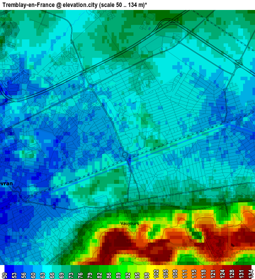
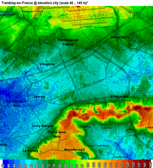
Below is the Elevation map of Tremblay-en-France, which displays elevation range with different colors. Scale of the first map is from 50 to 134 m (164 to 440 ft) with average elevation of 70.7 meters (=232 ft) [note 1]
These maps also provides idea of topography and contour of this city, they are displayed at different zoom levels. More info about maps, scale and edge coordinates you can find below images.
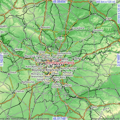
| \ | Map #1 | Map #2 | Topo.Map |
| Scale [m] | 50..134 m | 40..145 m | × |
| Scale [ft] | 164..440 ft | 131..476 ft | × |
| Average | 70.7 m = 232 ft | 75.1 m = 246 ft | × |
| Width | 6.42 km = 4 mi | 12.84 km = 8 mi | 205.4 km = 127.6 mi |
| Height | 6.42 km = 4 mi | 12.84 km = 8 mi | 205.4 km = 127.6 mi |
| ↑Max Latitude | 48.978412° | 49.007246° | 49.86454° |
| Latitude at center | 48.94956° | 48.94956° | 48.94956° |
| ↓Min Latitude | 48.920692° | 48.891807° | 48.01748° |
| ← Min Longitude | 2.524455° | 2.480509° | 1.16215° |
| Longitude center | 2.5684° | 2.5684° | 2.5684° |
| →Max Longitude | 2.612345° | 2.656291° | 3.97465° |
Nearby cities:
Cities around Tremblay-en-France sort by population:
• Aulnay-sous-Bois elevation 45 m
5.6 km,  256°
256°
• Sevran 55 m
3 km, 259°
• Livry-Gargan 76 m
3.8 km,  208°
208°
• Villepinte 57 m
3 km,  297°
297°
• Clichy-sous-Bois 115 m
4.5 km,  194°
194°
• Villeparisis 64 m
3.5 km,  103°
103°
• Montfermeil 105 m
5.8 km,  172°
172°
• Mitry-Mory 71 m
5.1 km,  43°
43°
• Courtry 80 m
4.3 km,  142°
142°
• Vaujours 86 m
2.2 km, 174°
• Coubron 70 m
3.8 km,  163°
163°
• Le Pin 72 m
5.8 km,  131°
131°
Multilingual:
 En español:
Tremblay-en-France elevación 64 m.
 En France:
Tremblay-en-France élévation 64 m.
 Auf Deutsch:
Tremblay-en-France höhe über dem Meeresspiegel ist 64 m.

Sources and notes:
- [note 1] Map square and city borders are not equal. Map elevation data is calculated only from area inside that square.
- [src 1] Elevation data from geonames database provided with same terms of usage.
- [src 2] The elevation map of Tremblay-en-France is generated using elevation data from NASA's 3 arcsec (90m) resolution SRTM data.
- [src 3] Base (background) map © OpenStreetMap contributors tiles are generated by Geofabrik and OpenTopoMap.
Copyright & License:
This Tremblay-en-France Elevation Map is licensed under CC BY-SA. You may reuse any part from this page, if you give a proper credit by linking to this URL:
 More info on terms of use page.