Saint-Flour elevation
Saint-Flour (Auvergne-Rhône-Alpes, Cantal), France elevation is 799 meters and Saint-Flour elevation in feet is 2621 ft above sea level [src 1]. Saint-Flour is a seat of a third-order administrative division (feature code) with elevation that is 625 meters (2051 ft) bigger than average city elevation in France.
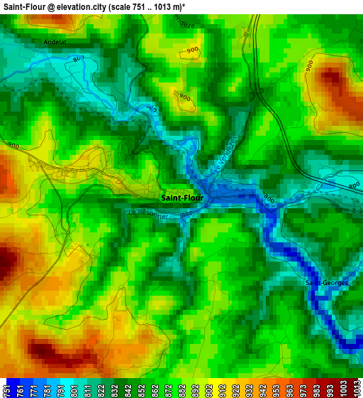
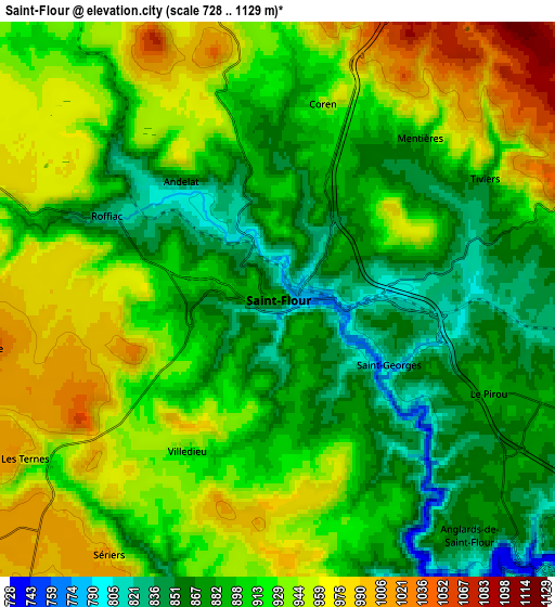
Below is the Elevation map of Saint-Flour, which displays elevation range with different colors. Scale of the first map is from 751 to 1013 m (2464 to 3323 ft) with average elevation of 865.3 meters (=2839 ft) [note 1]
These maps also provides idea of topography and contour of this city, they are displayed at different zoom levels. More info about maps, scale and edge coordinates you can find below images.
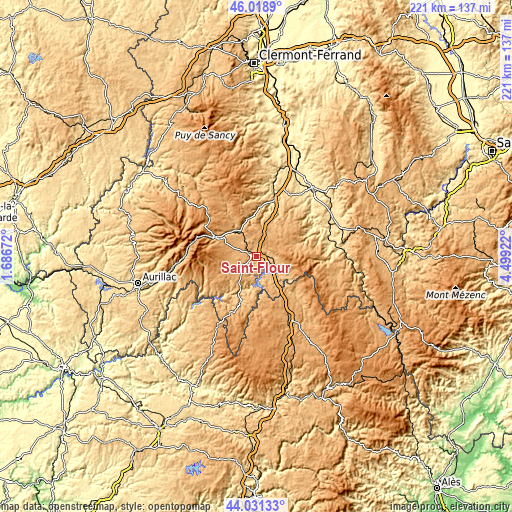
| \ | Map #1 | Map #2 | Topo.Map |
| Scale [m] | 751..1013 m | 728..1129 m | × |
| Scale [ft] | 2464..3323 ft | 2388..3704 ft | × |
| Average | 865.3 m = 2839 ft | 913.2 m = 2996 ft | × |
| Width | 6.91 km = 4.3 mi | 13.81 km = 8.6 mi | 221 km = 137.3 mi |
| Height | 6.91 km = 4.3 mi | 13.81 km = 8.6 mi | 221 km = 137.3 mi |
| ↑Max Latitude | 45.064787° | 45.095818° | 46.0189° |
| Latitude at center | 45.03374° | 45.03374° | 45.03374° |
| ↓Min Latitude | 45.002676° | 44.971595° | 44.03133° |
| ← Min Longitude | 3.049025° | 3.005079° | 1.68672° |
| Longitude center | 3.09297° | 3.09297° | 3.09297° |
| →Max Longitude | 3.136915° | 3.180861° | 4.49922° |
Nearby cities:
Cities around Saint-Flour sort by population:
• Langeac elevation 480 m
32.4 km,  76°
76°
• Murat 1004 m
19.6 km,  295°
295°
• Saugues 971 m
36.7 km,  102°
102°
• Massiac 596 m
25.6 km,  18°
18°
• Saint-Alban-sur-Limagnole 971 m
36.5 km,  140°
140°
• Vieille-Brioude 493 m
35.5 km,  43°
43°
• Allanche 1072 m
25 km,  330°
330°
• Neussargues 804 m
13.9 km,  318°
318°
• Neuvéglise 932 m
14.6 km,  216°
216°
• Le Malzieu-Ville 868 m
27.3 km, 136°
• Pierrefort 940 m
23.6 km,  238°
238°
• Chaudes-Aigues 837 m
21.1 km,  199°
199°
Multilingual:
 En español:
Saint-Flour elevación 799 m.
 En France:
Saint-Flour élévation 799 m.
 Auf Deutsch:
Saint-Flour höhe über dem Meeresspiegel ist 799 m.

Sources and notes:
- [note 1] Map square and city borders are not equal. Map elevation data is calculated only from area inside that square.
- [src 1] Elevation data from geonames database provided with same terms of usage.
- [src 2] The elevation map of Saint-Flour is generated using elevation data from NASA's 3 arcsec (90m) resolution SRTM data.
- [src 3] Base (background) map © OpenStreetMap contributors tiles are generated by Geofabrik and OpenTopoMap.
Copyright & License:
This Saint-Flour Elevation Map is licensed under CC BY-SA. You may reuse any part from this page, if you give a proper credit by linking to this URL:
 More info on terms of use page.