Murat elevation
Murat (Auvergne-Rhône-Alpes, Cantal), France elevation is 1004 meters and Murat elevation in feet is 3294 ft above sea level [src 1]. Murat is a populated place (feature code) with elevation that is 830 meters (2723 ft) bigger than average city elevation in France.
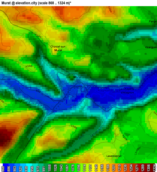
Below is the Elevation map of Murat, which displays elevation range with different colors. Scale of the first map is from 868 to 1324 m (2848 to 4344 ft) with average elevation of 1052.2 meters (=3452 ft) [note 1]
These maps also provides idea of topography and contour of this city, they are displayed at different zoom levels. More info about maps, scale and edge coordinates you can find below images.
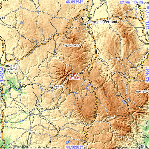
| \ | Map #1 | Topo.Map |
| Scale [m] | 868..1324 m | × |
| Scale [ft] | 2848..4344 ft | × |
| Average | 1052.2 m = 3452 ft | × |
| Width | 6.9 km = 4.3 mi | 220.7 km = 137.1 mi |
| Height | 6.9 km = 4.3 mi | 220.7 km = 137.1 mi |
| ↑Max Latitude | 45.141116° | 46.09394° |
| Latitude at center | 45.11011° | 45.11011° |
| ↓Min Latitude | 45.079087° | 44.10903° |
| ← Min Longitude | 2.824645° | 1.46234° |
| Longitude center | 2.86859° | 2.86859° |
| →Max Longitude | 2.912535° | 4.27484° |
Nearby cities:
Cities around Murat sort by population:
• Saint-Flour elevation 799 m
19.6 km,  115°
115°
• Riom-ès-Montagnes 912 m
25.2 km,  319°
319°
• Vic-sur-Cère 670 m
24 km,  232°
232°
• Massiac 596 m
30.2 km,  58°
58°
• Polminhac 664 m
28.9 km, 232°
• Condat 727 m
27.1 km,  341°
341°
• Allanche 1072 m
14.2 km,  21°
21°
• Neussargues 804 m
8.7 km,  76°
76°
• Saint-Simon 721 m
33.9 km,  241°
241°
• Neuvéglise 932 m
22.2 km,  155°
155°
• Pierrefort 940 m
21.1 km,  186°
186°
• Chaudes-Aigues 837 m
30.3 km, 159°
Multilingual:
 En español:
Murat elevación 1004 m.
 En France:
Murat élévation 1004 m.


Sources and notes:
- [note 1] Map square and city borders are not equal. Map elevation data is calculated only from area inside that square.
- [src 1] Elevation data from geonames database provided with same terms of usage.
- [src 2] The elevation map of Murat is generated using elevation data from NASA's 3 arcsec (90m) resolution SRTM data.
- [src 3] Base (background) map © OpenStreetMap contributors tiles are generated by Geofabrik and OpenTopoMap.
Copyright & License:
This Murat Elevation Map is licensed under CC BY-SA. You may reuse any part from this page, if you give a proper credit by linking to this URL:
 More info on terms of use page.