Neussargues elevation
Neussargues (Auvergne-Rhône-Alpes, Cantal), France elevation is 804 meters and Neussargues elevation in feet is 2638 ft above sea level [src 1]. Neussargues is a populated place (feature code) with elevation that is 630 meters (2067 ft) bigger than average city elevation in France.
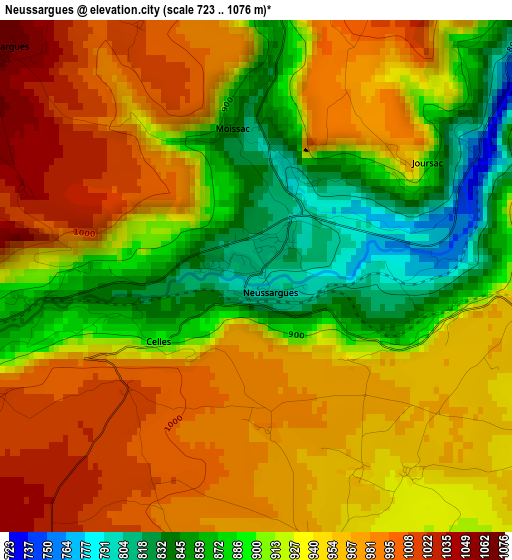
Below is the Elevation map of Neussargues, which displays elevation range with different colors. Scale of the first map is from 723 to 1076 m (2372 to 3530 ft) with average elevation of 933.7 meters (=3063 ft) [note 1]
These maps also provides idea of topography and contour of this city, they are displayed at different zoom levels. More info about maps, scale and edge coordinates you can find below images.
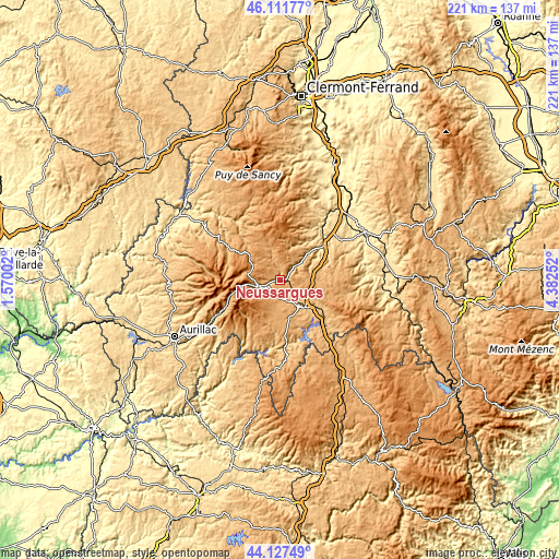
| \ | Map #1 | Topo.Map |
| Scale [m] | 723..1076 m | × |
| Scale [ft] | 2372..3530 ft | × |
| Average | 933.7 m = 3063 ft | × |
| Width | 6.89 km = 4.3 mi | 220.6 km = 137.1 mi |
| Height | 6.89 km = 4.3 mi | 220.6 km = 137.1 mi |
| ↑Max Latitude | 45.159256° | 46.11177° |
| Latitude at center | 45.12826° | 45.12826° |
| ↓Min Latitude | 45.097247° | 44.12749° |
| ← Min Longitude | 2.932325° | 1.57002° |
| Longitude center | 2.97627° | 2.97627° |
| →Max Longitude | 3.020215° | 4.38252° |
Nearby cities:
Cities around Neussargues sort by population:
• Saint-Flour elevation 799 m
13.9 km,  138°
138°
• Riom-ès-Montagnes 912 m
30.1 km,  304°
304°
• Murat 1004 m
8.7 km,  256°
256°
• Vic-sur-Cère 670 m
32.1 km,  239°
239°
• Massiac 596 m
22.1 km,  51°
51°
• Vieille-Brioude 493 m
36.8 km,  65°
65°
• Condat 727 m
29.2 km,  324°
324°
• Allanche 1072 m
11.7 km,  343°
343°
• Neuvéglise 932 m
22.3 km,  178°
178°
• Bournoncle-Saint-Pierre 464 m
35.9 km, 48°
• Pierrefort 940 m
25.4 km,  205°
205°
• Chaudes-Aigues 837 m
30.5 km, 175°
Multilingual:
 En español:
Neussargues elevación 804 m.
 En France:
Neussargues élévation 804 m.
 Auf Deutsch:
Neussargues höhe über dem Meeresspiegel ist 804 m.

Sources and notes:
- [note 1] Map square and city borders are not equal. Map elevation data is calculated only from area inside that square.
- [src 1] Elevation data from geonames database provided with same terms of usage.
- [src 2] The elevation map of Neussargues is generated using elevation data from NASA's 3 arcsec (90m) resolution SRTM data.
- [src 3] Base (background) map © OpenStreetMap contributors tiles are generated by Geofabrik and OpenTopoMap.
Copyright & License:
This Neussargues Elevation Map is licensed under CC BY-SA. You may reuse any part from this page, if you give a proper credit by linking to this URL:
 More info on terms of use page.