Langeac elevation
Langeac (Auvergne-Rhône-Alpes, Haute-Loire), France elevation is 480 meters and Langeac elevation in feet is 1575 ft above sea level [src 1]. Langeac is a populated place (feature code) with elevation that is 306 meters (1004 ft) bigger than average city elevation in France.
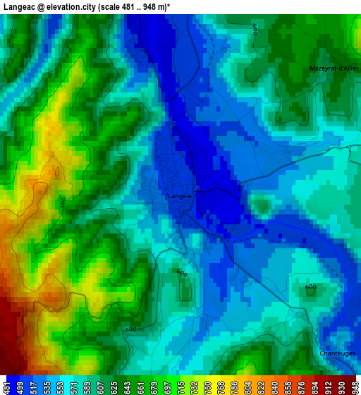
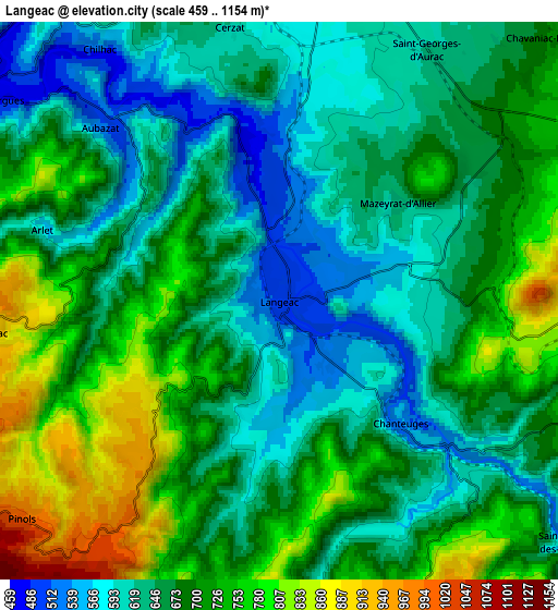
Below is the Elevation map of Langeac, which displays elevation range with different colors. Scale of the first map is from 481 to 948 m (1578 to 3110 ft) with average elevation of 606.4 meters (=1990 ft) [note 1]
These maps also provides idea of topography and contour of this city, they are displayed at different zoom levels. More info about maps, scale and edge coordinates you can find below images.
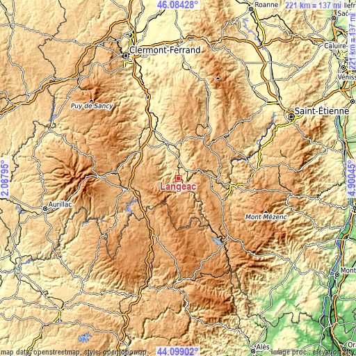
| \ | Map #1 | Map #2 | Topo.Map |
| Scale [m] | 481..948 m | 459..1154 m | × |
| Scale [ft] | 1578..3110 ft | 1506..3786 ft | × |
| Average | 606.4 m = 1990 ft | 678 m = 2224 ft | × |
| Width | 6.9 km = 4.3 mi | 13.8 km = 8.6 mi | 220.7 km = 137.1 mi |
| Height | 6.9 km = 4.3 mi | 13.8 km = 8.6 mi | 220.7 km = 137.1 mi |
| ↑Max Latitude | 45.131291° | 45.162285° | 46.08428° |
| Latitude at center | 45.10028° | 45.10028° | 45.10028° |
| ↓Min Latitude | 45.069252° | 45.038207° | 44.09902° |
| ← Min Longitude | 3.450255° | 3.406309° | 2.08795° |
| Longitude center | 3.4942° | 3.4942° | 3.4942° |
| →Max Longitude | 3.538145° | 3.582091° | 4.90045° |
Nearby cities:
Cities around Langeac sort by population:
• Brioude elevation 418 m
23.2 km,  338°
338°
• Espaly-Saint-Marcel 639 m
29.7 km,  101°
101°
• Polignac 751 m
28.9 km, 96°
• Saugues 971 m
16.1 km,  164°
164°
• Saint-Paulien 814 m
25.3 km,  80°
80°
• Massiac 596 m
28.7 km,  305°
305°
• Bains 979 m
24.3 km,  114°
114°
• Vieille-Brioude 493 m
19.6 km, 339°
• Allègre 1055 m
20.3 km,  57°
57°
• Paulhaguet 550 m
12.1 km,  7°
7°
• Le Malzieu-Ville 868 m
29.9 km,  205°
205°
• Bournoncle-Saint-Pierre 464 m
30.4 km,  333°
333°
Multilingual:
 En español:
Langeac elevación 480 m.
 En France:
Langeac élévation 480 m.


Sources and notes:
- [note 1] Map square and city borders are not equal. Map elevation data is calculated only from area inside that square.
- [src 1] Elevation data from geonames database provided with same terms of usage.
- [src 2] The elevation map of Langeac is generated using elevation data from NASA's 3 arcsec (90m) resolution SRTM data.
- [src 3] Base (background) map © OpenStreetMap contributors tiles are generated by Geofabrik and OpenTopoMap.
Copyright & License:
This Langeac Elevation Map is licensed under CC BY-SA. You may reuse any part from this page, if you give a proper credit by linking to this URL:
 More info on terms of use page.