Paulhaguet elevation
Paulhaguet (Auvergne-Rhône-Alpes, Haute-Loire), France elevation is 550 meters and Paulhaguet elevation in feet is 1804 ft above sea level [src 1]. Paulhaguet is a populated place (feature code) with elevation that is 376 meters (1234 ft) bigger than average city elevation in France.
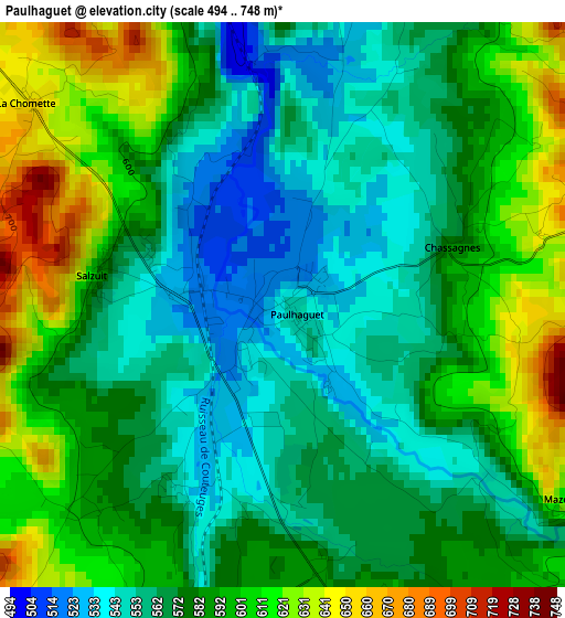
Below is the Elevation map of Paulhaguet, which displays elevation range with different colors. Scale of the first map is from 494 to 748 m (1621 to 2454 ft) with average elevation of 581.3 meters (=1907 ft) [note 1]
These maps also provides idea of topography and contour of this city, they are displayed at different zoom levels. More info about maps, scale and edge coordinates you can find below images.
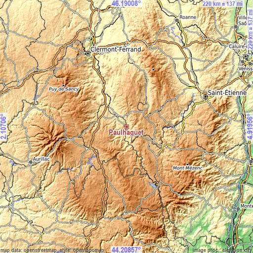
| \ | Map #1 | Topo.Map |
| Scale [m] | 494..748 m | × |
| Scale [ft] | 1621..2454 ft | × |
| Average | 581.3 m = 1907 ft | × |
| Width | 6.89 km = 4.3 mi | 220.3 km = 136.9 mi |
| Height | 6.89 km = 4.3 mi | 220.3 km = 136.9 mi |
| ↑Max Latitude | 45.238903° | 46.19008° |
| Latitude at center | 45.20795° | 45.20795° |
| ↓Min Latitude | 45.176981° | 44.20857° |
| ← Min Longitude | 3.469365° | 2.10706° |
| Longitude center | 3.51331° | 3.51331° |
| →Max Longitude | 3.557255° | 4.91956° |
Nearby cities:
Cities around Paulhaguet sort by population:
• Brioude elevation 418 m
13.9 km,  313°
313°
• Langeac 480 m
12.1 km,  187°
187°
• Brassac-les-Mines 403 m
27.1 km,  327°
327°
• Sainte-Florine 402 m
26.8 km, 325°
• Saint-Paulien 814 m
24.8 km,  108°
108°
• Massiac 596 m
25.2 km,  281°
281°
• Vergongheon 434 m
23.6 km,  320°
320°
• Lempdes-sur-Allagnon 437 m
26.5 km, 317°
• Fontannes 1035 m
22.2 km,  62°
62°
• Vieille-Brioude 493 m
10.6 km, 306°
• Allègre 1055 m
15.6 km,  93°
93°
• Bournoncle-Saint-Pierre 464 m
21.4 km, 314°
Multilingual:
 En español:
Paulhaguet elevación 550 m.
 En France:
Paulhaguet élévation 550 m.
 Auf Deutsch:
Paulhaguet höhe über dem Meeresspiegel ist 550 m.

Sources and notes:
- [note 1] Map square and city borders are not equal. Map elevation data is calculated only from area inside that square.
- [src 1] Elevation data from geonames database provided with same terms of usage.
- [src 2] The elevation map of Paulhaguet is generated using elevation data from NASA's 3 arcsec (90m) resolution SRTM data.
- [src 3] Base (background) map © OpenStreetMap contributors tiles are generated by Geofabrik and OpenTopoMap.
Copyright & License:
This Paulhaguet Elevation Map is licensed under CC BY-SA. You may reuse any part from this page, if you give a proper credit by linking to this URL:
 More info on terms of use page.