Sainte-Florine elevation
Sainte-Florine (Auvergne-Rhône-Alpes, Haute-Loire), France elevation is 402 meters and Sainte-Florine elevation in feet is 1319 ft above sea level [src 1]. Sainte-Florine is a populated place (feature code) with elevation that is 228 meters (748 ft) bigger than average city elevation in France.
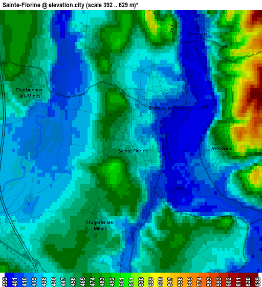
Below is the Elevation map of Sainte-Florine, which displays elevation range with different colors. Scale of the first map is from 392 to 629 m (1286 to 2064 ft) with average elevation of 444.9 meters (=1460 ft) [note 1]
These maps also provides idea of topography and contour of this city, they are displayed at different zoom levels. More info about maps, scale and edge coordinates you can find below images.
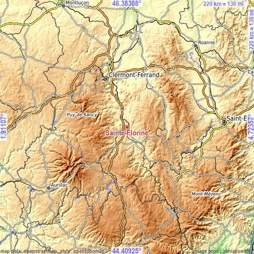
| \ | Map #1 | Topo.Map |
| Scale [m] | 392..629 m | × |
| Scale [ft] | 1286..2064 ft | × |
| Average | 444.9 m = 1460 ft | × |
| Width | 6.86 km = 4.3 mi | 219.6 km = 136.5 mi |
| Height | 6.86 km = 4.3 mi | 219.5 km = 136.4 mi |
| ↑Max Latitude | 45.436035° | 46.38388° |
| Latitude at center | 45.40519° | 45.40519° |
| ↓Min Latitude | 45.374328° | 44.40925° |
| ← Min Longitude | 3.273375° | 1.91107° |
| Longitude center | 3.31732° | 3.31732° |
| →Max Longitude | 3.361265° | 4.72357° |
Nearby cities:
Cities around Sainte-Florine sort by population:
• Issoire elevation 387 m
16.4 km,  340°
340°
• Brioude 418 m
13.4 km,  157°
157°
• Brassac-les-Mines 403 m
1.3 km,  42°
42°
• Auzat-la-Combelle 457 m
5.2 km,  0°
0°
• Massiac 596 m
19.5 km,  208°
208°
• Vergongheon 434 m
3.8 km,  177°
177°
• Saint-Germain-Lembron 415 m
8.4 km,  314°
314°
• Lempdes-sur-Allagnon 437 m
3.6 km,  227°
227°
• Vieille-Brioude 493 m
17.1 km, 156°
• Sauxillanges 467 m
16.8 km,  14°
14°
• Le Breuil-sur-Couze 393 m
8.2 km,  329°
329°
• Bournoncle-Saint-Pierre 464 m
6.9 km, 179°
Multilingual:
 En español:
Sainte-Florine elevación 402 m.
 En France:
Sainte-Florine élévation 402 m.
 Auf Deutsch:
Sainte-Florine höhe über dem Meeresspiegel ist 402 m.

Sources and notes:
- [note 1] Map square and city borders are not equal. Map elevation data is calculated only from area inside that square.
- [src 1] Elevation data from geonames database provided with same terms of usage.
- [src 2] The elevation map of Sainte-Florine is generated using elevation data from NASA's 3 arcsec (90m) resolution SRTM data.
- [src 3] Base (background) map © OpenStreetMap contributors tiles are generated by Geofabrik and OpenTopoMap.
Copyright & License:
This Sainte-Florine Elevation Map is licensed under CC BY-SA. You may reuse any part from this page, if you give a proper credit by linking to this URL:
 More info on terms of use page.