Saint-Martin-des-Noyers elevation
Saint-Martin-des-Noyers (Pays de la Loire, Département de la Vendée), France elevation is 86 meters and Saint-Martin-des-Noyers elevation in feet is 282 ft above sea level [src 1]. Saint-Martin-des-Noyers is a populated place (feature code) with elevation that is 88 meters (289 ft) smaller than average city elevation in France.
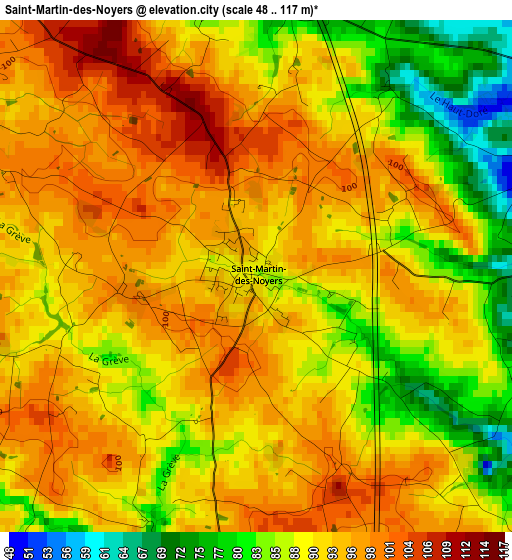
Below is the Elevation map of Saint-Martin-des-Noyers, which displays elevation range with different colors. Scale of the first map is from 48 to 117 m (157 to 384 ft) with average elevation of 91.5 meters (=300 ft) [note 1]
These maps also provides idea of topography and contour of this city, they are displayed at different zoom levels. More info about maps, scale and edge coordinates you can find below images.
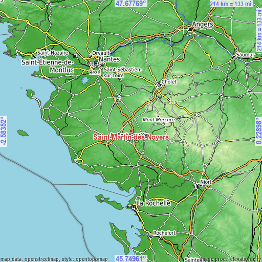
| \ | Map #1 | Topo.Map |
| Scale [m] | 48..117 m | × |
| Scale [ft] | 157..384 ft | × |
| Average | 91.5 m = 300 ft | × |
| Width | 6.7 km = 4.2 mi | 214.4 km = 133.2 mi |
| Height | 6.7 km = 4.2 mi | 214.4 km = 133.2 mi |
| ↑Max Latitude | 46.752378° | 47.67769° |
| Latitude at center | 46.72226° | 46.72226° |
| ↓Min Latitude | 46.692126° | 45.74961° |
| ← Min Longitude | -1.221215° | -2.58352° |
| Longitude center | -1.17727° | -1.17727° |
| →Max Longitude | -1.133325° | 0.22898° |
Nearby cities:
Cities around Saint-Martin-des-Noyers sort by population:
• Chantonnay elevation 61 m
10.4 km,  112°
112°
• Les Essarts 84 m
7 km,  326°
326°
• La Ferrière 92 m
10.5 km,  265°
265°
• Dompierre-sur-Yon 76 m
15.9 km,  276°
276°
• Saint-Fulgent 83 m
14.5 km,  359°
359°
• La Chaize-le-Vicomte 82 m
10.3 km,  236°
236°
• Bournezeau 79 m
9.5 km,  177°
177°
• Mouchamps 100 m
11 km,  53°
53°
• Chauché 72 m
13.9 km, 328°
• Sainte-Cécile 54 m
5.3 km,  64°
64°
• Saint-Germain-de-Prinçay 74 m
11.9 km,  90°
90°
• Vendrennes 86 m
12.2 km,  19°
19°
Multilingual:
 En español:
Saint-Martin-des-Noyers elevación 86 m.
 En France:
Saint-Martin-des-Noyers élévation 86 m.
 Auf Deutsch:
Saint-Martin-des-Noyers höhe über dem Meeresspiegel ist 86 m.
 На русском:
Saint-Martin-des-Noyers высота над уровнем моря 86 м
Sources and notes:
- [note 1] Map square and city borders are not equal. Map elevation data is calculated only from area inside that square.
- [src 1] Elevation data from geonames database provided with same terms of usage.
- [src 2] The elevation map of Saint-Martin-des-Noyers is generated using elevation data from NASA's 3 arcsec (90m) resolution SRTM data.
- [src 3] Base (background) map © OpenStreetMap contributors tiles are generated by Geofabrik and OpenTopoMap.
Copyright & License:
This Saint-Martin-des-Noyers Elevation Map is licensed under CC BY-SA. You may reuse any part from this page, if you give a proper credit by linking to this URL:
 More info on terms of use page.