Villey-Saint-Étienne elevation
Villey-Saint-Étienne (Grand Est, Meurthe-et-Moselle), France elevation is 231 meters and Villey-Saint-Étienne elevation in feet is 758 ft above sea level [src 1]. Villey-Saint-Étienne is a populated place (feature code) with elevation that is 57 meters (187 ft) bigger than average city elevation in France.
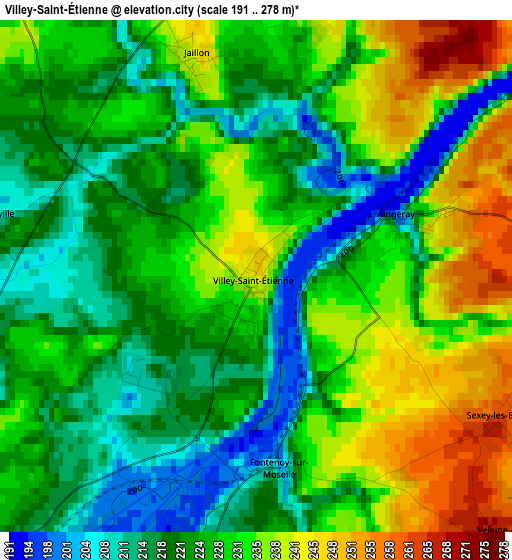
Below is the Elevation map of Villey-Saint-Étienne, which displays elevation range with different colors. Scale of the first map is from 191 to 278 m (627 to 912 ft) with average elevation of 227.1 meters (=745 ft) [note 1]
These maps also provides idea of topography and contour of this city, they are displayed at different zoom levels. More info about maps, scale and edge coordinates you can find below images.
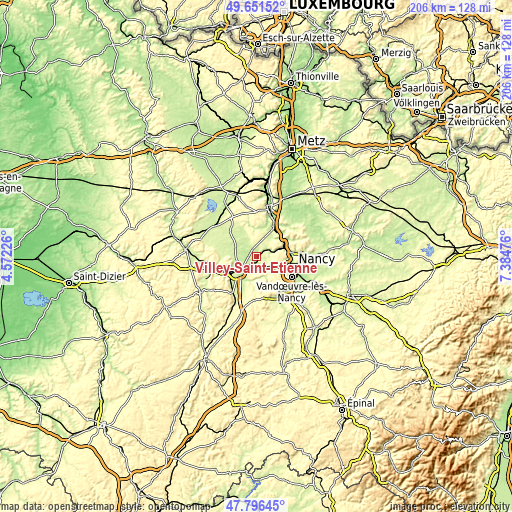
| \ | Map #1 | Topo.Map |
| Scale [m] | 191..278 m | × |
| Scale [ft] | 627..912 ft | × |
| Average | 227.1 m = 745 ft | × |
| Width | 6.45 km = 4 mi | 206.3 km = 128.2 mi |
| Height | 6.45 km = 4 mi | 206.3 km = 128.2 mi |
| ↑Max Latitude | 48.761517° | 49.65152° |
| Latitude at center | 48.73254° | 48.73254° |
| ↓Min Latitude | 48.703546° | 47.79645° |
| ← Min Longitude | 5.934565° | 4.57226° |
| Longitude center | 5.97851° | 5.97851° |
| →Max Longitude | 6.022455° | 7.38476° |
Nearby cities:
Cities around Villey-Saint-Étienne sort by population:
• Toul elevation 206 m
8.6 km,  228°
228°
• Frouard 206 m
11.5 km,  74°
74°
• Champigneulles 193 m
13.4 km,  89°
89°
• Liverdun 205 m
6.5 km, 72°
• Pompey 190 m
11.6 km, 69°
• Écrouves 231 m
11.6 km,  239°
239°
• Gondreville 209 m
4.4 km,  193°
193°
• Marbache 187 m
11.9 km,  51°
51°
• Dommartin-lès-Toul 220 m
8.6 km,  215°
215°
• Velaine-en-Haye 288 m
5.1 km,  135°
135°
• Belleville 186 m
13.2 km,  43°
43°
• Saizerais 250 m
8.2 km, 36°
Multilingual:
 En español:
Villey-Saint-Étienne elevación 231 m.
 En France:
Villey-Saint-Étienne élévation 231 m.
 Auf Deutsch:
Villey-Saint-Étienne höhe über dem Meeresspiegel ist 231 m.
 На русском:
Villey-Saint-Étienne высота над уровнем моря 231 м
Sources and notes:
- [note 1] Map square and city borders are not equal. Map elevation data is calculated only from area inside that square.
- [src 1] Elevation data from geonames database provided with same terms of usage.
- [src 2] The elevation map of Villey-Saint-Étienne is generated using elevation data from NASA's 3 arcsec (90m) resolution SRTM data.
- [src 3] Base (background) map © OpenStreetMap contributors tiles are generated by Geofabrik and OpenTopoMap.
Copyright & License:
This Villey-Saint-Étienne Elevation Map is licensed under CC BY-SA. You may reuse any part from this page, if you give a proper credit by linking to this URL:
 More info on terms of use page.