Toul elevation
Toul (Grand Est, Meurthe-et-Moselle), France elevation is 206 meters and Toul elevation in feet is 676 ft above sea level [src 1]. Toul is a seat of a third-order administrative division (feature code) with elevation that is 32 meters (105 ft) bigger than average city elevation in France.
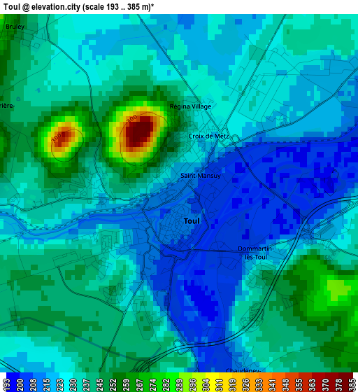
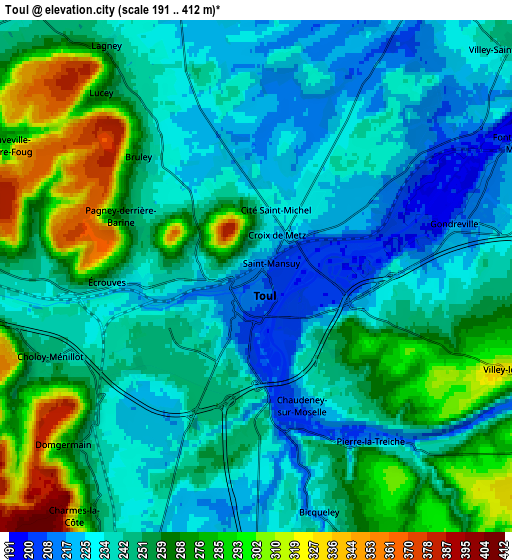
Below is the Elevation map of Toul, which displays elevation range with different colors. Scale of the first map is from 193 to 385 m (633 to 1263 ft) with average elevation of 231.3 meters (=759 ft) [note 1]
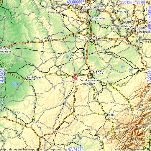
These maps also provides idea of topography and contour of this city, they are displayed at different zoom levels. More info about maps, scale and edge coordinates you can find below images.
| \ | Map #1 | Map #2 | Topo.Map |
| Scale [m] | 193..385 m | 191..412 m | × |
| Scale [ft] | 633..1263 ft | 627..1352 ft | × |
| Average | 231.3 m = 759 ft | 250.1 m = 821 ft | × |
| Width | 6.45 km = 4 mi | 12.9 km = 8 mi | 206.5 km = 128.3 mi |
| Height | 6.45 km = 4 mi | 12.9 km = 8 mi | 206.5 km = 128.3 mi |
| ↑Max Latitude | 48.709757° | 48.738747° | 49.60069° |
| Latitude at center | 48.68075° | 48.68075° | 48.68075° |
| ↓Min Latitude | 48.651727° | 48.622686° | 47.7437° |
| ← Min Longitude | 5.847205° | 5.803259° | 4.4849° |
| Longitude center | 5.89115° | 5.89115° | 5.89115° |
| →Max Longitude | 5.935095° | 5.979041° | 7.2974° |
Nearby cities:
Cities around Toul sort by population:
• Liverdun elevation 205 m
14.8 km,  58°
58°
• Écrouves 231 m
3.6 km,  268°
268°
• Chaligny 287 m
15.4 km,  114°
114°
• Foug 256 m
7.6 km, 272°
• Gondreville 209 m
5.6 km,  75°
75°
• Dommartin-lès-Toul 220 m
1.9 km,  132°
132°
• Velaine-en-Haye 288 m
10.2 km, 77°
• Colombey-les-Belles 340 m
16.9 km,  179°
179°
• Saizerais 250 m
16.8 km,  42°
42°
• Domgermain 238 m
6.2 km,  226°
226°
• Villey-Saint-Étienne 231 m
8.6 km,  48°
48°
• Blénod-lès-Toul 263 m
9.9 km,  203°
203°
Multilingual:
 En español:
Toul elevación 206 m.
 En France:
Toul élévation 206 m.


Sources and notes:
- [note 1] Map square and city borders are not equal. Map elevation data is calculated only from area inside that square.
- [src 1] Elevation data from geonames database provided with same terms of usage.
- [src 2] The elevation map of Toul is generated using elevation data from NASA's 3 arcsec (90m) resolution SRTM data.
- [src 3] Base (background) map © OpenStreetMap contributors tiles are generated by Geofabrik and OpenTopoMap.
Copyright & License:
This Toul Elevation Map is licensed under CC BY-SA. You may reuse any part from this page, if you give a proper credit by linking to this URL:
 More info on terms of use page.