Vimoutiers elevation
Vimoutiers (Normandy, Département de l'Orne), France elevation is 100 meters and Vimoutiers elevation in feet is 328 ft above sea level [src 1]. Vimoutiers is a populated place (feature code) with elevation that is 74 meters (243 ft) smaller than average city elevation in France.
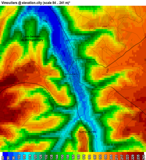
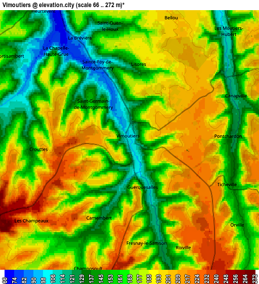
Below is the Elevation map of Vimoutiers, which displays elevation range with different colors. Scale of the first map is from 84 to 241 m (276 to 791 ft) with average elevation of 169.6 meters (=556 ft) [note 1]
These maps also provides idea of topography and contour of this city, they are displayed at different zoom levels. More info about maps, scale and edge coordinates you can find below images.
| \ | Map #1 | Map #2 | Topo.Map |
| Scale [m] | 84..241 m | 66..272 m | × |
| Scale [ft] | 276..791 ft | 217..892 ft | × |
| Average | 169.6 m = 556 ft | 173.7 m = 570 ft | × |
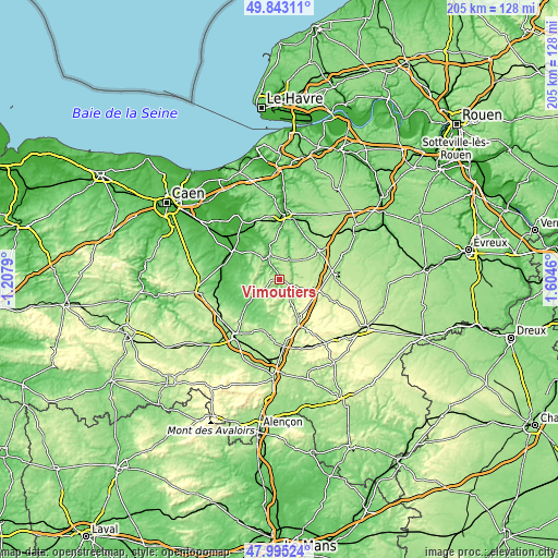
| Width | 6.42 km = 4 mi | 12.84 km = 8 mi | 205.5 km = 127.7 mi |
| Height | 6.42 km = 4 mi | 12.84 km = 8 mi | 205.4 km = 127.6 mi |
| ↑Max Latitude | 48.956584° | 48.985432° | 49.84311° |
| Latitude at center | 48.92772° | 48.92772° | 48.92772° |
| ↓Min Latitude | 48.898839° | 48.869942° | 47.99524° |
| ← Min Longitude | 0.154405° | 0.110459° | -1.2079° |
| Longitude center | 0.19835° | 0.19835° | 0.19835° |
| →Max Longitude | 0.242295° | 0.286241° | 1.6046° |
Nearby cities:
Cities around Vimoutiers sort by population:
• Lisieux elevation 65 m
24.4 km,  5°
5°
• Argentan 159 m
25.9 km,  218°
218°
• Canon 31 m
26.7 km,  307°
307°
• Saint-Pierre-sur-Dives 35 m
19.6 km,  300°
300°
• Orbec 149 m
18.8 km,  58°
58°
• Livarot 69 m
9.3 km,  337°
337°
• Gacé 198 m
16.6 km,  154°
154°
• Saint-Désir 50 m
23.7 km,  2°
2°
• Trun 81 m
15.4 km,  232°
232°
• Broglie 148 m
25.8 km,  69°
69°
• Beuvillers 47 m
22.8 km, 10°
• La Vespière 129 m
18.7 km, 56°
Multilingual:
 En español:
Vimoutiers elevación 100 m.
 En France:
Vimoutiers élévation 100 m.
 Auf Deutsch:
Vimoutiers höhe über dem Meeresspiegel ist 100 m.

Sources and notes:
- [note 1] Map square and city borders are not equal. Map elevation data is calculated only from area inside that square.
- [src 1] Elevation data from geonames database provided with same terms of usage.
- [src 2] The elevation map of Vimoutiers is generated using elevation data from NASA's 3 arcsec (90m) resolution SRTM data.
- [src 3] Base (background) map © OpenStreetMap contributors tiles are generated by Geofabrik and OpenTopoMap.
Copyright & License:
This Vimoutiers Elevation Map is licensed under CC BY-SA. You may reuse any part from this page, if you give a proper credit by linking to this URL:
 More info on terms of use page.