Lisieux elevation
Lisieux (Normandy, Calvados), France elevation is 65 meters and Lisieux elevation in feet is 213 ft above sea level [src 1]. Lisieux is a seat of a third-order administrative division (feature code) with elevation that is 109 meters (358 ft) smaller than average city elevation in France.
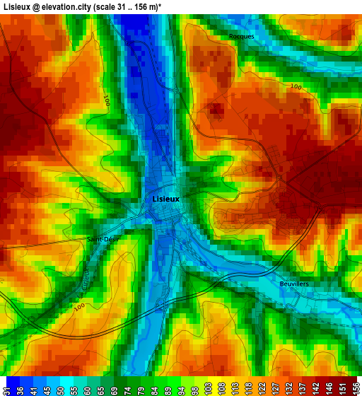
Below is the Elevation map of Lisieux, which displays elevation range with different colors. Scale of the first map is from 31 to 156 m (102 to 512 ft) with average elevation of 98.9 meters (=324 ft) [note 1]
These maps also provides idea of topography and contour of this city, they are displayed at different zoom levels. More info about maps, scale and edge coordinates you can find below images.
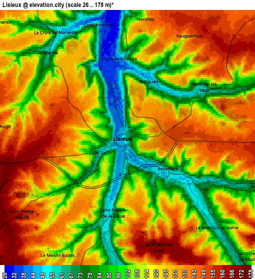
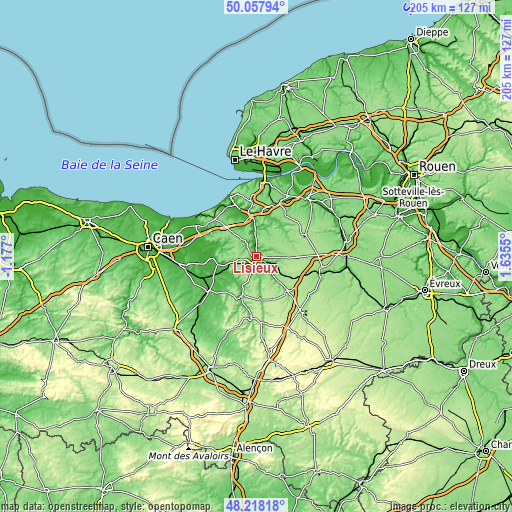
| \ | Map #1 | Map #2 | Topo.Map |
| Scale [m] | 31..156 m | 26..178 m | × |
| Scale [ft] | 102..512 ft | 85..584 ft | × |
| Average | 98.9 m = 324 ft | 116 m = 381 ft | × |
| Width | 6.39 km = 4 mi | 12.78 km = 7.9 mi | 204.6 km = 127.1 mi |
| Height | 6.39 km = 4 mi | 12.78 km = 7.9 mi | 204.5 km = 127.1 mi |
| ↑Max Latitude | 49.175337° | 49.204058° | 50.05794° |
| Latitude at center | 49.1466° | 49.1466° | 49.1466° |
| ↓Min Latitude | 49.117846° | 49.089075° | 48.21818° |
| ← Min Longitude | 0.185305° | 0.141359° | -1.177° |
| Longitude center | 0.22925° | 0.22925° | 0.22925° |
| →Max Longitude | 0.273195° | 0.317141° | 1.6355° |
Nearby cities:
Cities around Lisieux sort by population:
• Pont-l’Évêque elevation 12 m
16.1 km,  350°
350°
• Orbec 149 m
19.9 km,  136°
136°
• Livarot 69 m
16.8 km,  200°
200°
• Saint-Désir 50 m
1.3 km,  238°
238°
• Thiberville 171 m
16.5 km,  93°
93°
• Moyaux 158 m
10.7 km,  59°
59°
• Cormeilles 70 m
15.5 km,  43°
43°
• Lieurey 171 m
21.7 km, 64°
• Épaignes 157 m
21.3 km,  45°
45°
• Cambremer 97 m
13.2 km,  272°
272°
• Beuvillers 47 m
2.7 km, 135°
• La Vespière 129 m
19.4 km, 136°
Multilingual:
 En español:
Lisieux elevación 65 m.
 En France:
Lisieux élévation 65 m.


Sources and notes:
- [note 1] Map square and city borders are not equal. Map elevation data is calculated only from area inside that square.
- [src 1] Elevation data from geonames database provided with same terms of usage.
- [src 2] The elevation map of Lisieux is generated using elevation data from NASA's 3 arcsec (90m) resolution SRTM data.
- [src 3] Base (background) map © OpenStreetMap contributors tiles are generated by Geofabrik and OpenTopoMap.
Copyright & License:
This Lisieux Elevation Map is licensed under CC BY-SA. You may reuse any part from this page, if you give a proper credit by linking to this URL:
 More info on terms of use page.