Canon elevation
Canon (Normandy, Calvados), France elevation is 31 meters and Canon elevation in feet is 102 ft above sea level [src 1]. Canon is a populated place (feature code) with elevation that is 143 meters (469 ft) smaller than average city elevation in France.
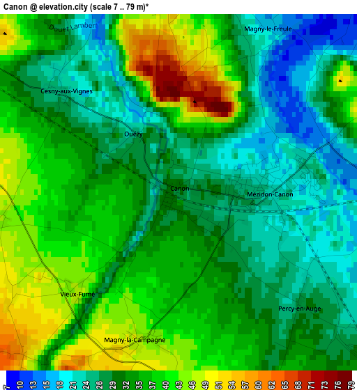
Below is the Elevation map of Canon, which displays elevation range with different colors. Scale of the first map is from 7 to 79 m (23 to 259 ft) with average elevation of 33.4 meters (=110 ft) [note 1]
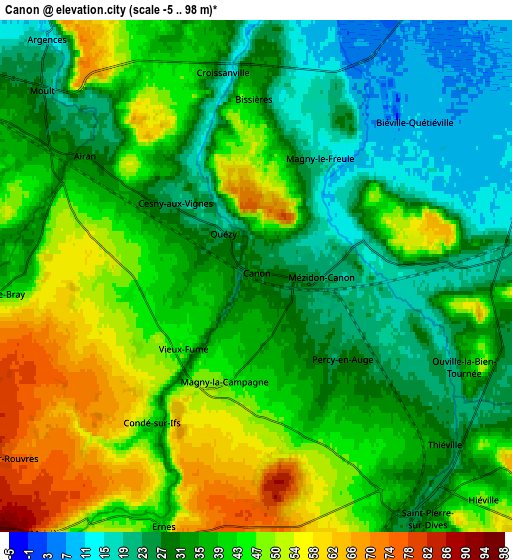
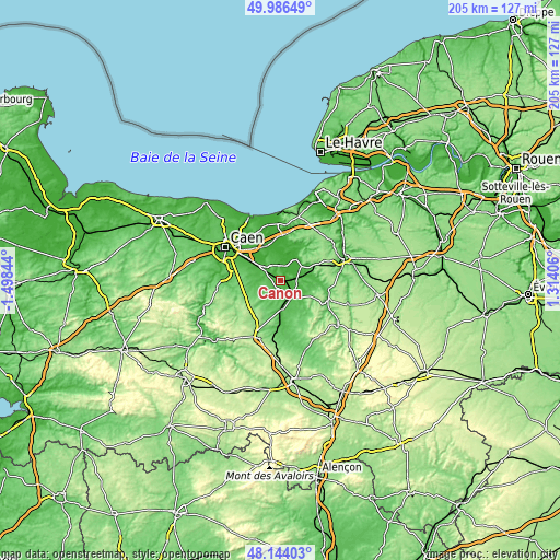
These maps also provides idea of topography and contour of this city, they are displayed at different zoom levels. More info about maps, scale and edge coordinates you can find below images.
| \ | Map #1 | Map #2 | Topo.Map |
| Scale [m] | 7..79 m | -5..98 m | × |
| Scale [ft] | 23..259 ft | -16..322 ft | × |
| Average | 33.4 m = 110 ft | 37.5 m = 123 ft | × |
| Width | 6.4 km = 4 mi | 12.8 km = 8 mi | 204.9 km = 127.3 mi |
| Height | 6.4 km = 4 mi | 12.8 km = 8 mi | 204.8 km = 127.3 mi |
| ↑Max Latitude | 49.10258° | 49.131343° | 49.98649° |
| Latitude at center | 49.0738° | 49.0738° | 49.0738° |
| ↓Min Latitude | 49.045004° | 49.016191° | 48.14403° |
| ← Min Longitude | -0.136135° | -0.180081° | -1.49844° |
| Longitude center | -0.09219° | -0.09219° | -0.09219° |
| →Max Longitude | -0.048245° | -0.004299° | 1.31406° |
Nearby cities:
Cities around Canon sort by population:
• Saint-Pierre-sur-Dives elevation 35 m
7.7 km,  145°
145°
• Argences 17 m
8 km,  317°
317°
• Troarn 25 m
13.3 km,  330°
330°
• Soliers 34 m
16.3 km,  294°
294°
• Potigny 160 m
15.9 km,  223°
223°
• Cagny 21 m
14.4 km,  303°
303°
• Sannerville 18 m
15.2 km, 320°
• Bellengreville 26 m
10.2 km, 303°
• Saint-Sylvain 45 m
9.3 km,  257°
257°
• Moult 23 m
7 km,  310°
310°
• Cambremer 97 m
13.4 km,  49°
49°
• Bourguébus 50 m
15.9 km, 289°
Multilingual:
 En español:
Canon elevación 31 m.
 En France:
Canon élévation 31 m.


Sources and notes:
- [note 1] Map square and city borders are not equal. Map elevation data is calculated only from area inside that square.
- [src 1] Elevation data from geonames database provided with same terms of usage.
- [src 2] The elevation map of Canon is generated using elevation data from NASA's 3 arcsec (90m) resolution SRTM data.
- [src 3] Base (background) map © OpenStreetMap contributors tiles are generated by Geofabrik and OpenTopoMap.
Copyright & License:
This Canon Elevation Map is licensed under CC BY-SA. You may reuse any part from this page, if you give a proper credit by linking to this URL:
 More info on terms of use page.