Argentan elevation
Argentan (Normandy, Département de l'Orne), France elevation is 159 meters and Argentan elevation in feet is 522 ft above sea level [src 1]. Argentan is a seat of a third-order administrative division (feature code) with elevation that is 15 meters (49 ft) smaller than average city elevation in France.
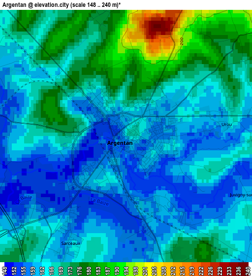
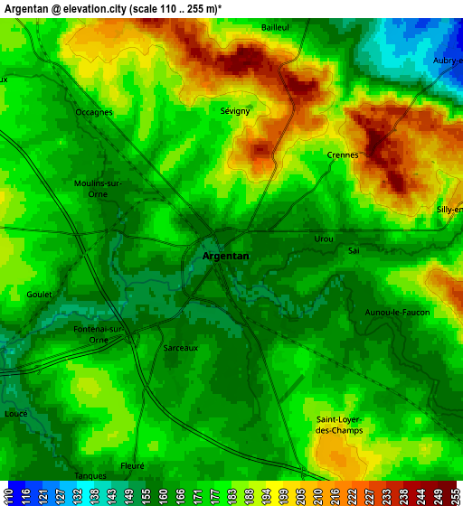
Below is the Elevation map of Argentan, which displays elevation range with different colors. Scale of the first map is from 148 to 240 m (486 to 787 ft) with average elevation of 166.9 meters (=548 ft) [note 1]
These maps also provides idea of topography and contour of this city, they are displayed at different zoom levels. More info about maps, scale and edge coordinates you can find below images.
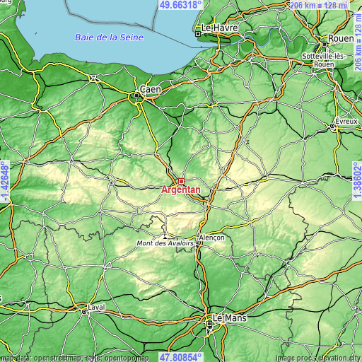
| \ | Map #1 | Map #2 | Topo.Map |
| Scale [m] | 148..240 m | 110..255 m | × |
| Scale [ft] | 486..787 ft | 361..837 ft | × |
| Average | 166.9 m = 548 ft | 175.5 m = 576 ft | × |
| Width | 6.44 km = 4 mi | 12.89 km = 8 mi | 206.2 km = 128.1 mi |
| Height | 6.44 km = 4 mi | 12.89 km = 8 mi | 206.2 km = 128.1 mi |
| ↑Max Latitude | 48.77338° | 48.802333° | 49.66318° |
| Latitude at center | 48.74441° | 48.74441° | 48.74441° |
| ↓Min Latitude | 48.715423° | 48.68642° | 47.80854° |
| ← Min Longitude | -0.064175° | -0.108121° | -1.42648° |
| Longitude center | -0.02023° | -0.02023° | -0.02023° |
| →Max Longitude | 0.023715° | 0.067661° | 1.38602° |
Nearby cities:
Cities around Argentan sort by population:
• Falaise elevation 142 m
20.8 km,  322°
322°
• Sées 186 m
21.1 km,  137°
137°
• Vimoutiers 100 m
25.9 km,  38°
38°
• Gacé 198 m
23.8 km,  76°
76°
• Briouze 216 m
26 km,  258°
258°
• Écouché 154 m
8.2 km,  248°
248°
• Trun 81 m
11.6 km,  19°
19°
• Mortrée 176 m
13.8 km,  148°
148°
• Courteilles 223 m
13.6 km,  284°
284°
• Radon 177 m
28.4 km,  161°
161°
• Pont-Écrepin 127 m
16.6 km, 277°
• Putanges-Pont-Écrepin 139 m
17 km, 278°
Multilingual:
 En español:
Argentan elevación 159 m.
 En France:
Argentan élévation 159 m.
 Auf Deutsch:
Argentan höhe über dem Meeresspiegel ist 159 m.

Sources and notes:
- [note 1] Map square and city borders are not equal. Map elevation data is calculated only from area inside that square.
- [src 1] Elevation data from geonames database provided with same terms of usage.
- [src 2] The elevation map of Argentan is generated using elevation data from NASA's 3 arcsec (90m) resolution SRTM data.
- [src 3] Base (background) map © OpenStreetMap contributors tiles are generated by Geofabrik and OpenTopoMap.
Copyright & License:
This Argentan Elevation Map is licensed under CC BY-SA. You may reuse any part from this page, if you give a proper credit by linking to this URL:
 More info on terms of use page.