Konso elevation
Konso (SNNPR), Ethiopia elevation is 1031 meters and Konso elevation in feet is 3383 ft above sea level [src 1]. Konso is a populated place (feature code) with elevation that is 865 meters (2838 ft) smaller than average city elevation in Ethiopia.
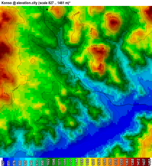
Below is the Elevation map of Konso, which displays elevation range with different colors. Scale of the first map is from 827 to 1461 m (2713 to 4793 ft) with average elevation of 1068.3 meters (=3505 ft) [note 1]
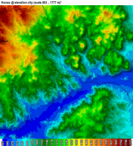
These maps also provides idea of topography and contour of this city, they are displayed at different zoom levels. More info about maps, scale and edge coordinates you can find below images.
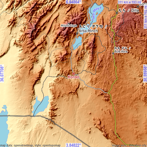
| \ | Map #1 | Map #2 | Topo.Map |
| Scale [m] | 827..1461 m | 803..1777 m | × |
| Scale [ft] | 2713..4793 ft | 2635..5830 ft | × |
| Average | 1068.3 m = 3505 ft | 1141.2 m = 3744 ft | × |
| Width | 9.73 km = 6 mi | 19.46 km = 12.1 mi | 311.4 km = 193.5 mi |
| Height | 9.73 km = 6 mi | 19.46 km = 12.1 mi | 311.4 km = 193.5 mi |
| ↑Max Latitude | 5.293759° | 5.337516° | 6.64864° |
| Latitude at center | 5.25° | 5.25° | 5.25° |
| ↓Min Latitude | 5.206238° | 5.162472° | 3.84822° |
| ← Min Longitude | 37.439385° | 37.395439° | 36.07708° |
| Longitude center | 37.48333° | 37.48333° | 37.48333° |
| →Max Longitude | 37.527275° | 37.571221° | 38.88958° |
Nearby cities:
Cities around Konso sort by population:
• Arba Minch elevation 1269 m
87.4 km,  4°
4°
• Dīla 1594 m
159.1 km,  35°
35°
• Shakiso 1741 m
168 km,  70°
70°
• Felege Neway 1361 m
134.3 km,  330°
330°
• Jinka 1430 m
102.4 km,  295°
295°
• Hagere Maryam 1883 m
93.6 km,  62°
62°
• Bako 1401 m
117.5 km, 300°
• Yabēlo 1906 m
78 km,  121°
121°
• Gīdolē 2102 m
46.3 km,  343°
343°
• Mēga 1819 m
161.2 km,  145°
145°
• Lobuni 367 m
160.1 km,  253°
253°
• Turmi 917 m
115.1 km, 254°
Multilingual:
 En español:
Konso elevación 1031 m.
 En France:
Konso élévation 1031 m.


Sources and notes:
- [note 1] Map square and city borders are not equal. Map elevation data is calculated only from area inside that square.
- [src 1] Elevation data from geonames database provided with same terms of usage.
- [src 2] The elevation map of Konso is generated using elevation data from NASA's 3 arcsec (90m) resolution SRTM data.
- [src 3] Base (background) map © OpenStreetMap contributors tiles are generated by Geofabrik and OpenTopoMap.
Copyright & License:
This Konso Elevation Map is licensed under CC BY-SA. You may reuse any part from this page, if you give a proper credit by linking to this URL:
 More info on terms of use page.