Shakiso elevation
Shakiso (Oromiya), Ethiopia elevation is 1741 meters and Shakiso elevation in feet is 5712 ft above sea level [src 1]. Shakiso is a populated place (feature code) with elevation that is 155 meters (509 ft) smaller than average city elevation in Ethiopia.
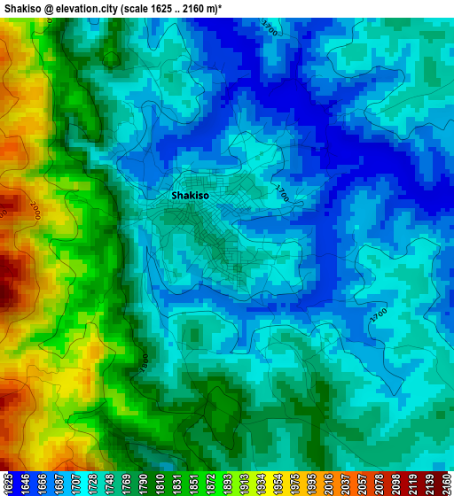
Below is the Elevation map of Shakiso, which displays elevation range with different colors. Scale of the first map is from 1625 to 2160 m (5331 to 7087 ft) with average elevation of 1766.5 meters (=5796 ft) [note 1]
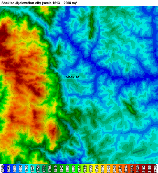
These maps also provides idea of topography and contour of this city, they are displayed at different zoom levels. More info about maps, scale and edge coordinates you can find below images.
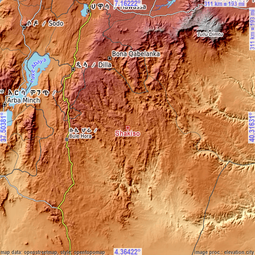
| \ | Map #1 | Map #2 | Topo.Map |
| Scale [m] | 1625..2160 m | 1613..2208 m | × |
| Scale [ft] | 5331..7087 ft | 5292..7244 ft | × |
| Average | 1766.5 m = 5796 ft | 1805.2 m = 5923 ft | × |
| Width | 9.72 km = 6 mi | 19.45 km = 12.1 mi | 311.1 km = 193.3 mi |
| Height | 9.72 km = 6 mi | 19.45 km = 12.1 mi | 311.1 km = 193.3 mi |
| ↑Max Latitude | 5.808661° | 5.852379° | 7.16222° |
| Latitude at center | 5.76494° | 5.76494° | 5.76494° |
| ↓Min Latitude | 5.721215° | 5.677487° | 4.36422° |
| ← Min Longitude | 38.866115° | 38.822169° | 37.50381° |
| Longitude center | 38.91006° | 38.91006° | 38.91006° |
| →Max Longitude | 38.954005° | 38.997951° | 40.31631° |
Nearby cities:
Cities around Shakiso sort by population:
• Hawassa elevation 1697 m
152 km,  341°
341°
• Dīla 1594 m
97.8 km,  317°
317°
• Yirga ‘Alem 1778 m
122.4 km,  333°
333°
• Kibre Mengist 1690 m
15.5 km,  31°
31°
• Āsasa 2369 m
151.9 km,  12°
12°
• Dodola 2464 m
138.8 km, 12°
• Hagere Maryam 1883 m
76 km,  258°
258°
• Yabēlo 1906 m
134.1 km,  223°
223°
• Wendo 1911 m
107.7 km, 329°
• Leku 1873 m
133.5 km, 337°
• Kofelē 2666 m
145.4 km,  354°
354°
• Hāgere Selam 2746 m
90.9 km, 331°
Multilingual:
 En español:
Shakiso elevación 1741 m.
 En France:
Shakiso élévation 1741 m.
 Auf Deutsch:
Shakiso höhe über dem Meeresspiegel ist 1741 m.

Sources and notes:
- [note 1] Map square and city borders are not equal. Map elevation data is calculated only from area inside that square.
- [src 1] Elevation data from geonames database provided with same terms of usage.
- [src 2] The elevation map of Shakiso is generated using elevation data from NASA's 3 arcsec (90m) resolution SRTM data.
- [src 3] Base (background) map © OpenStreetMap contributors tiles are generated by Geofabrik and OpenTopoMap.
Copyright & License:
This Shakiso Elevation Map is licensed under CC BY-SA. You may reuse any part from this page, if you give a proper credit by linking to this URL:
 More info on terms of use page.