Mēga elevation
Mēga (Oromiya), Ethiopia elevation is 1819 meters and Mēga elevation in feet is 5968 ft above sea level [src 1]. Mēga is a populated place (feature code) with elevation that is 77 meters (253 ft) smaller than average city elevation in Ethiopia.
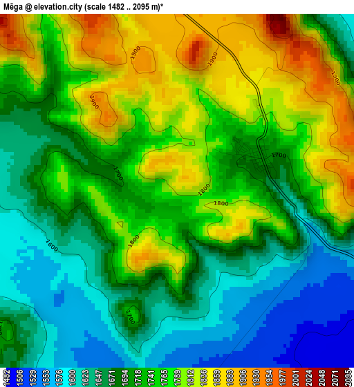
Below is the Elevation map of Mēga, which displays elevation range with different colors. Scale of the first map is from 1482 to 2095 m (4862 to 6873 ft) with average elevation of 1724.5 meters (=5658 ft) [note 1]
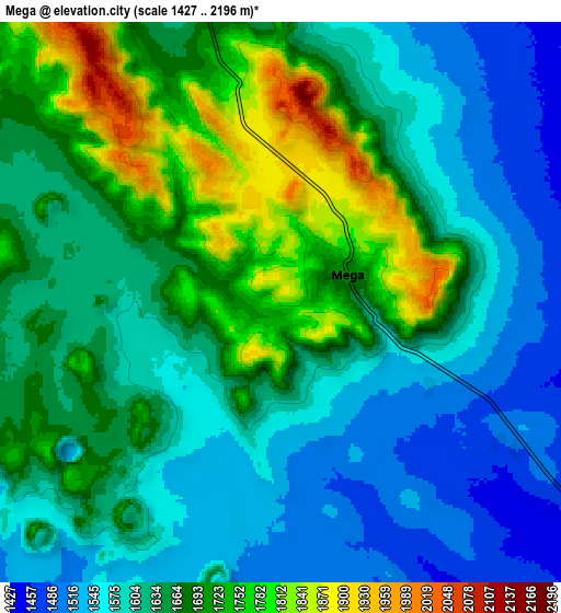
These maps also provides idea of topography and contour of this city, they are displayed at different zoom levels. More info about maps, scale and edge coordinates you can find below images.
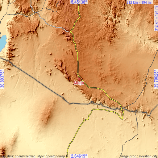
| \ | Map #1 | Map #2 | Topo.Map |
| Scale [m] | 1482..2095 m | 1427..2196 m | × |
| Scale [ft] | 4862..6873 ft | 4682..7205 ft | × |
| Average | 1724.5 m = 5658 ft | 1642 m = 5387 ft | × |
| Width | 9.75 km = 6.1 mi | 19.5 km = 12.1 mi | 311.9 km = 193.8 mi |
| Height | 9.75 km = 6.1 mi | 19.5 km = 12.1 mi | 311.9 km = 193.8 mi |
| ↑Max Latitude | 4.093834° | 4.137666° | 5.45138° |
| Latitude at center | 4.05° | 4.05° | 4.05° |
| ↓Min Latitude | 4.006163° | 3.962324° | 2.64619° |
| ← Min Longitude | 38.256055° | 38.212109° | 36.89375° |
| Longitude center | 38.3° | 38.3° | 38.3° |
| →Max Longitude | 38.343945° | 38.387891° | 39.70625° |
Nearby cities:
Cities around Mēga sort by population:
• Arba Minch elevation 1269 m
235.7 km,  339°
339°
• Dīla 1594 m
263.2 km,  0°
0°
• Shakiso 1741 m
202.3 km,  19°
19°
• Jinka 1430 m
255.1 km,  314°
314°
• Kibre Mengist 1690 m
217.4 km, 20°
• Hagere Maryam 1883 m
176.3 km,  357°
357°
• Yabēlo 1906 m
95.7 km,  345°
345°
• Gīdolē 2102 m
205.8 km,  329°
329°
• Hāgere Selam 2746 m
271.6 km,  5°
5°
• Konso 1031 m
161.2 km, 325°
• Lobuni 367 m
259 km,  289°
289°
• Turmi 917 m
225.7 km,  296°
296°
Multilingual:
 En español:
Mēga elevación 1819 m.
 En France:
Mēga élévation 1819 m.


Sources and notes:
- [note 1] Map square and city borders are not equal. Map elevation data is calculated only from area inside that square.
- [src 1] Elevation data from geonames database provided with same terms of usage.
- [src 2] The elevation map of Mēga is generated using elevation data from NASA's 3 arcsec (90m) resolution SRTM data.
- [src 3] Base (background) map © OpenStreetMap contributors tiles are generated by Geofabrik and OpenTopoMap.
Copyright & License:
This Mēga Elevation Map is licensed under CC BY-SA. You may reuse any part from this page, if you give a proper credit by linking to this URL:
 More info on terms of use page.