Gīdolē elevation
Gīdolē (SNNPR), Ethiopia elevation is 2102 meters and Gīdolē elevation in feet is 6896 ft above sea level [src 1]. Gīdolē is a populated place (feature code) with elevation that is 206 meters (676 ft) bigger than average city elevation in Ethiopia.
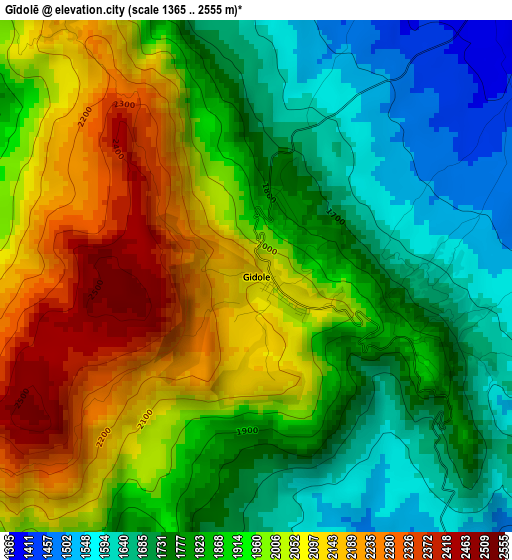
Below is the Elevation map of Gīdolē, which displays elevation range with different colors. Scale of the first map is from 1365 to 2555 m (4478 to 8383 ft) with average elevation of 1904.5 meters (=6248 ft) [note 1]
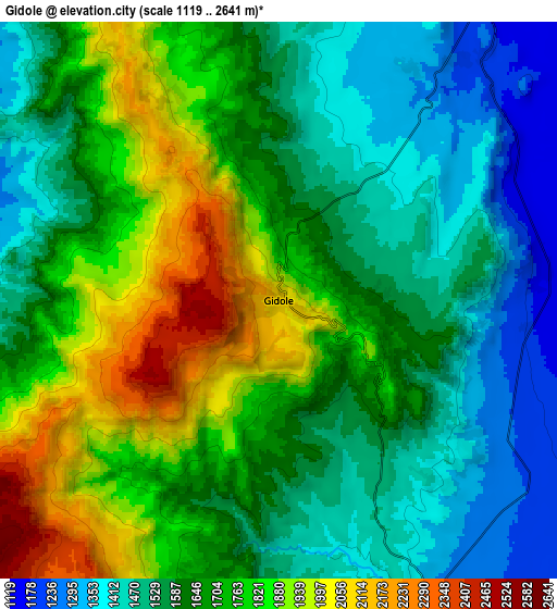
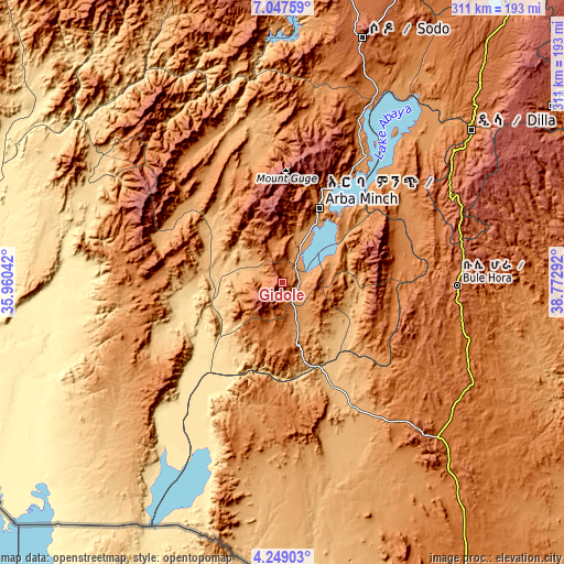
These maps also provides idea of topography and contour of this city, they are displayed at different zoom levels. More info about maps, scale and edge coordinates you can find below images.
| \ | Map #1 | Map #2 | Topo.Map |
| Scale [m] | 1365..2555 m | 1119..2641 m | × |
| Scale [ft] | 4478..8383 ft | 3671..8665 ft | × |
| Average | 1904.5 m = 6248 ft | 1666.1 m = 5466 ft | × |
| Width | 9.72 km = 6 mi | 19.45 km = 12.1 mi | 311.2 km = 193.4 mi |
| Height | 9.72 km = 6 mi | 19.45 km = 12.1 mi | 311.2 km = 193.4 mi |
| ↑Max Latitude | 5.69373° | 5.737457° | 7.04759° |
| Latitude at center | 5.65° | 5.65° | 5.65° |
| ↓Min Latitude | 5.606267° | 5.56253° | 4.24903° |
| ← Min Longitude | 37.322725° | 37.278779° | 35.96042° |
| Longitude center | 37.36667° | 37.36667° | 37.36667° |
| →Max Longitude | 37.410615° | 37.454561° | 38.77292° |
Nearby cities:
Cities around Gīdolē sort by population:
• Sodo elevation 2045 m
141.4 km,  17°
17°
• Arba Minch 1269 m
47.2 km,  25°
25°
• Dīla 1594 m
135.3 km,  50°
50°
• Felege Neway 1361 m
89.9 km,  323°
323°
• Bodītī 1998 m
156.5 km, 20°
• Jinka 1430 m
79.3 km,  270°
270°
• Hagere Maryam 1883 m
96.2 km,  91°
91°
• Bako 1401 m
89.7 km,  279°
279°
• Yabēlo 1906 m
116.5 km,  137°
137°
• Wendo 1911 m
156.9 km, 47°
• Konso 1031 m
46.3 km,  163°
163°
• Turmi 917 m
123.8 km,  232°
232°
Multilingual:
 En español:
Gīdolē elevación 2102 m.
 En France:
Gīdolē élévation 2102 m.


Sources and notes:
- [note 1] Map square and city borders are not equal. Map elevation data is calculated only from area inside that square.
- [src 1] Elevation data from geonames database provided with same terms of usage.
- [src 2] The elevation map of Gīdolē is generated using elevation data from NASA's 3 arcsec (90m) resolution SRTM data.
- [src 3] Base (background) map © OpenStreetMap contributors tiles are generated by Geofabrik and OpenTopoMap.
Copyright & License:
This Gīdolē Elevation Map is licensed under CC BY-SA. You may reuse any part from this page, if you give a proper credit by linking to this URL:
 More info on terms of use page.