Valdelacalzada elevation
Valdelacalzada (Extremadura, Provincia de Badajoz), Spain elevation is 184 meters and Valdelacalzada elevation in feet is 604 ft above sea level [src 1]. Valdelacalzada is a seat of a third-order administrative division (feature code) with elevation that is 419 meters (1375 ft) smaller than average city elevation in Spain.
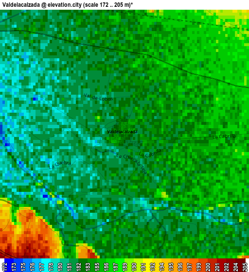
Below is the Elevation map of Valdelacalzada, which displays elevation range with different colors. Scale of the first map is from 172 to 205 m (564 to 673 ft) with average elevation of 183.5 meters (=602 ft) [note 1]
These maps also provides idea of topography and contour of this city, they are displayed at different zoom levels. More info about maps, scale and edge coordinates you can find below images.
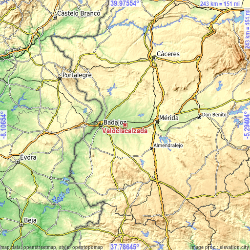
| \ | Map #1 | Topo.Map |
| Scale [m] | 172..205 m | × |
| Scale [ft] | 564..673 ft | × |
| Average | 183.5 m = 602 ft | × |
| Width | 7.61 km = 4.7 mi | 243.4 km = 151.2 mi |
| Height | 7.61 km = 4.7 mi | 243.4 km = 151.2 mi |
| ↑Max Latitude | 38.923627° | 39.97554° |
| Latitude at center | 38.88943° | 38.88943° |
| ↓Min Latitude | 38.855217° | 37.78645° |
| ← Min Longitude | -6.744235° | -8.10654° |
| Longitude center | -6.70029° | -6.70029° |
| →Max Longitude | -6.656345° | -5.29404° |
Nearby cities:
Cities around Valdelacalzada sort by population:
• Badajoz elevation 192 m
23.4 km,  266°
266°
• Montijo 201 m
7.4 km,  73°
73°
• Puebla de la Calzada 194 m
6.5 km,  85°
85°
• Talavera La Real 188 m
6 km,  257°
257°
• Arroyo de San Serván 232 m
21.7 km,  100°
100°
• Lobón 241 m
8 km,  124°
124°
• Solana de los Barros 264 m
23 km,  142°
142°
• La Garrovilla 204 m
19.6 km,  80°
80°
• La Albuera 258 m
21.9 km,  209°
209°
• Corte de Peleas 246 m
18.3 km,  171°
171°
• Torremayor 196 m
14.1 km, 84°
• Entrín Bajo 244 m
19 km,  183°
183°
Multilingual:
 En español:
Valdelacalzada elevación 184 m.
 En France:
Valdelacalzada élévation 184 m.
 Auf Deutsch:
Valdelacalzada höhe über dem Meeresspiegel ist 184 m.

Sources and notes:
- [note 1] Map square and city borders are not equal. Map elevation data is calculated only from area inside that square.
- [src 1] Elevation data from geonames database provided with same terms of usage.
- [src 2] The elevation map of Valdelacalzada is generated using elevation data from NASA's 3 arcsec (90m) resolution SRTM data.
- [src 3] Base (background) map © OpenStreetMap contributors tiles are generated by Geofabrik and OpenTopoMap.
Copyright & License:
This Valdelacalzada Elevation Map is licensed under CC BY-SA. You may reuse any part from this page, if you give a proper credit by linking to this URL:
 More info on terms of use page.