Entrín Bajo elevation
Entrín Bajo (Extremadura, Provincia de Badajoz), Spain elevation is 244 meters and Entrín Bajo elevation in feet is 801 ft above sea level [src 1]. Entrín Bajo is a seat of a third-order administrative division (feature code) with elevation that is 359 meters (1178 ft) smaller than average city elevation in Spain.
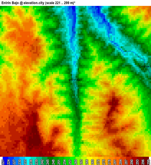
Below is the Elevation map of Entrín Bajo, which displays elevation range with different colors. Scale of the first map is from 221 to 299 m (725 to 981 ft) with average elevation of 263.9 meters (=866 ft) [note 1]
These maps also provides idea of topography and contour of this city, they are displayed at different zoom levels. More info about maps, scale and edge coordinates you can find below images.
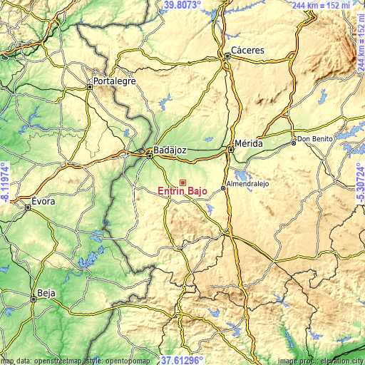
| \ | Map #1 | Topo.Map |
| Scale [m] | 221..299 m | × |
| Scale [ft] | 725..981 ft | × |
| Average | 263.9 m = 866 ft | × |
| Width | 7.62 km = 4.7 mi | 244 km = 151.6 mi |
| Height | 7.62 km = 4.7 mi | 244 km = 151.6 mi |
| ↑Max Latitude | 38.752829° | 39.8073° |
| Latitude at center | 38.71855° | 38.71855° |
| ↓Min Latitude | 38.684254° | 37.61296° |
| ← Min Longitude | -6.757435° | -8.11974° |
| Longitude center | -6.71349° | -6.71349° |
| →Max Longitude | -6.669545° | -5.30724° |
Nearby cities:
Cities around Entrín Bajo sort by population:
• Puebla de la Calzada elevation 194 m
21 km,  21°
21°
• Aceuchal 307 m
21.3 km,  112°
112°
• Talavera La Real 188 m
18.4 km,  344°
344°
• Santa Marta 341 m
13.8 km,  147°
147°
• Valdelacalzada 184 m
19 km,  3°
3°
• Lobón 241 m
16.4 km,  28°
28°
• Solana de los Barros 264 m
15.2 km,  87°
87°
• La Albuera 258 m
9.5 km,  269°
269°
• Almendral 325 m
14.9 km,  218°
218°
• Corte de Peleas 246 m
3.8 km,  77°
77°
• Torre de Miguel Sesmero 322 m
13.2 km,  212°
212°
• Nogales 373 m
15 km,  191°
191°
Multilingual:
 En español:
Entrín Bajo elevación 244 m.
 En France:
Entrín Bajo élévation 244 m.
 Auf Deutsch:
Entrín Bajo höhe über dem Meeresspiegel ist 244 m.

Sources and notes:
- [note 1] Map square and city borders are not equal. Map elevation data is calculated only from area inside that square.
- [src 1] Elevation data from geonames database provided with same terms of usage.
- [src 2] The elevation map of Entrín Bajo is generated using elevation data from NASA's 3 arcsec (90m) resolution SRTM data.
- [src 3] Base (background) map © OpenStreetMap contributors tiles are generated by Geofabrik and OpenTopoMap.
Copyright & License:
This Entrín Bajo Elevation Map is licensed under CC BY-SA. You may reuse any part from this page, if you give a proper credit by linking to this URL:
 More info on terms of use page.