Arroyo de San Serván elevation
Arroyo de San Serván (Extremadura, Provincia de Badajoz), Spain elevation is 232 meters and Arroyo de San Serván elevation in feet is 761 ft above sea level [src 1]. Arroyo de San Serván is a seat of a third-order administrative division (feature code) with elevation that is 371 meters (1217 ft) smaller than average city elevation in Spain.
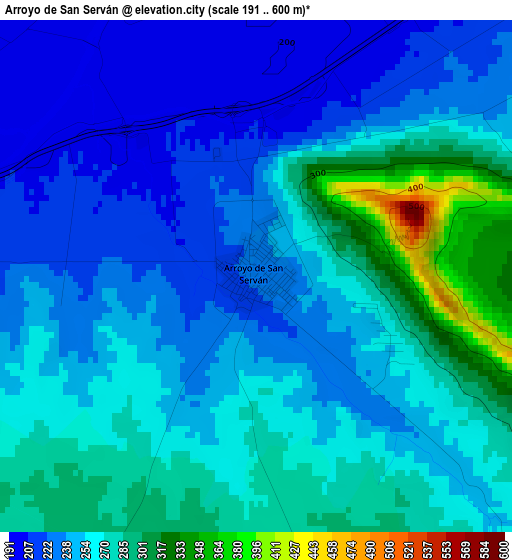
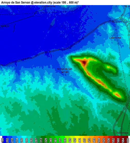
Below is the Elevation map of Arroyo de San Serván, which displays elevation range with different colors. Scale of the first map is from 191 to 600 m (627 to 1969 ft) with average elevation of 255 meters (=837 ft) [note 1]
These maps also provides idea of topography and contour of this city, they are displayed at different zoom levels. More info about maps, scale and edge coordinates you can find below images.
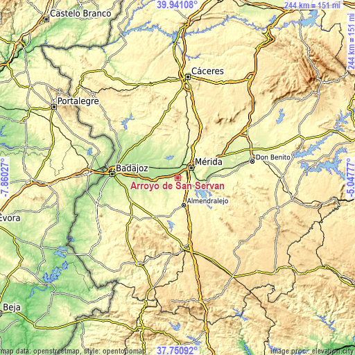
| \ | Map #1 | Map #2 | Topo.Map |
| Scale [m] | 191..600 m | 186..600 m | × |
| Scale [ft] | 627..1969 ft | 610..1969 ft | × |
| Average | 255 m = 837 ft | 253.3 m = 831 ft | × |
| Width | 7.61 km = 4.7 mi | 15.22 km = 9.5 mi | 243.5 km = 151.3 mi |
| Height | 7.61 km = 4.7 mi | 15.22 km = 9.5 mi | 243.5 km = 151.3 mi |
| ↑Max Latitude | 38.888644° | 38.922841° | 39.94108° |
| Latitude at center | 38.85443° | 38.85443° | 38.85443° |
| ↓Min Latitude | 38.8202° | 38.785953° | 37.75092° |
| ← Min Longitude | -6.497965° | -6.541911° | -7.86027° |
| Longitude center | -6.45402° | -6.45402° | -6.45402° |
| →Max Longitude | -6.410075° | -6.366129° | -5.04777° |
Nearby cities:
Cities around Arroyo de San Serván sort by population:
• Mérida elevation 229 m
11.8 km,  54°
54°
• Almendralejo 338 m
19.5 km,  168°
168°
• Montijo 201 m
15.4 km,  292°
292°
• Calamonte 237 m
6.9 km,  56°
56°
• Puebla de la Calzada 194 m
15.5 km, 286°
• Lobón 241 m
14.7 km,  267°
267°
• Solana de los Barros 264 m
16.1 km,  207°
207°
• La Garrovilla 204 m
7.5 km,  344°
344°
• Torremegía 305 m
9.8 km,  136°
136°
• Esparragalejo 235 m
10 km,  9°
9°
• Torremayor 196 m
9 km,  305°
305°
• Don Álvaro 264 m
15.5 km,  92°
92°
Multilingual:
 En español:
Arroyo de San Serván elevación 232 m.
 En France:
Arroyo de San Serván élévation 232 m.
 Auf Deutsch:
Arroyo de San Serván höhe über dem Meeresspiegel ist 232 m.
 На русском:
Arroyo de San Serván высота над уровнем моря 232 м
Sources and notes:
- [note 1] Map square and city borders are not equal. Map elevation data is calculated only from area inside that square.
- [src 1] Elevation data from geonames database provided with same terms of usage.
- [src 2] The elevation map of Arroyo de San Serván is generated using elevation data from NASA's 3 arcsec (90m) resolution SRTM data.
- [src 3] Base (background) map © OpenStreetMap contributors tiles are generated by Geofabrik and OpenTopoMap.
Copyright & License:
This Arroyo de San Serván Elevation Map is licensed under CC BY-SA. You may reuse any part from this page, if you give a proper credit by linking to this URL:
 More info on terms of use page.