Aragüés del Puerto elevation
Aragüés del Puerto (Aragon, Provincia de Huesca), Spain elevation is 948 meters and Aragüés del Puerto elevation in feet is 3110 ft above sea level [src 1]. Aragüés del Puerto is a seat of a third-order administrative division (feature code) with elevation that is 345 meters (1132 ft) bigger than average city elevation in Spain.
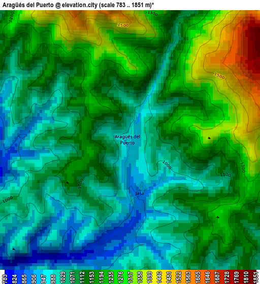
Below is the Elevation map of Aragüés del Puerto, which displays elevation range with different colors. Scale of the first map is from 783 to 1851 m (2569 to 6073 ft) with average elevation of 1132.8 meters (=3717 ft) [note 1]
These maps also provides idea of topography and contour of this city, they are displayed at different zoom levels. More info about maps, scale and edge coordinates you can find below images.
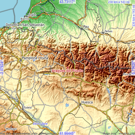
| \ | Map #1 | Topo.Map |
| Scale [m] | 783..1851 m | × |
| Scale [ft] | 2569..6073 ft | × |
| Average | 1132.8 m = 3717 ft | × |
| Width | 7.18 km = 4.5 mi | 229.8 km = 142.8 mi |
| Height | 7.18 km = 4.5 mi | 229.8 km = 142.8 mi |
| ↑Max Latitude | 42.738694° | 43.73117° |
| Latitude at center | 42.70641° | 42.70641° |
| ↓Min Latitude | 42.674109° | 41.66445° |
| ← Min Longitude | -0.713935° | -2.07624° |
| Longitude center | -0.66999° | -0.66999° |
| →Max Longitude | -0.626045° | 0.73626° |
Nearby cities:
Cities around Aragüés del Puerto sort by population:
• Jaca elevation 827 m
18.2 km,  147°
147°
• Echo 821 m
7.5 km,  298°
298°
• Canfranc 1056 m
11.8 km,  84°
84°
• Ansó 859 m
14.2 km,  293°
293°
• Villanúa 959 m
11.2 km,  105°
105°
• Puente la Reina de Jaca 593 m
19 km,  210°
210°
• Castiello de Jaca 899 m
13 km,  131°
131°
• Garde 734 m
22.8 km, 293°
• Santa Cruz de la Serós 801 m
20.4 km,  181°
181°
• Jasa 945 m
1.3 km,  165°
165°
• Borau 991 m
8.5 km, 128°
• Fago 1178 m
17.5 km,  280°
280°
Multilingual:
 En español:
Aragüés del Puerto elevación 948 m.
 En France:
Aragüés del Puerto élévation 948 m.
 Auf Deutsch:
Aragüés del Puerto höhe über dem Meeresspiegel ist 948 m.
 На русском:
Aragüés del Puerto высота над уровнем моря 948 м
Sources and notes:
- [note 1] Map square and city borders are not equal. Map elevation data is calculated only from area inside that square.
- [src 1] Elevation data from geonames database provided with same terms of usage.
- [src 2] The elevation map of Aragüés del Puerto is generated using elevation data from NASA's 3 arcsec (90m) resolution SRTM data.
- [src 3] Base (background) map © OpenStreetMap contributors tiles are generated by Geofabrik and OpenTopoMap.
Copyright & License:
This Aragüés del Puerto Elevation Map is licensed under CC BY-SA. You may reuse any part from this page, if you give a proper credit by linking to this URL:
 More info on terms of use page.